Litchfield Township, Meeker County, Minnesota
| Litchfield Township, Minnesota | |
|---|---|
| Township | |
 Litchfield Township, Minnesota Location within the state of Minnesota | |
| Coordinates: 45°7′N 94°33′W / 45.117°N 94.550°WCoordinates: 45°7′N 94°33′W / 45.117°N 94.550°W | |
| Country | United States |
| State | Minnesota |
| County | Meeker |
| Area | |
| • Total | 33.9 sq mi (87.9 km2) |
| • Land | 31.7 sq mi (82.2 km2) |
| • Water | 2.2 sq mi (5.7 km2) |
| Elevation | 1,148 ft (350 m) |
| Population (2000) | |
| • Total | 808 |
| • Density | 25.5/sq mi (9.8/km2) |
| Time zone | Central (CST) (UTC-6) |
| • Summer (DST) | CDT (UTC-5) |
| ZIP code | 55355 |
| Area code(s) | 320 |
| FIPS code | 27-37466[1] |
| GNIS feature ID | 0664798[2] |
Litchfield Township is a township in Meeker County, Minnesota, United States. The population was 808 at the 2000 census. The township includes most of the city of Litchfield, except for a small protrusion northeast into Forest City Township and another small one due east into Darwin Township.
Geography
According to the United States Census Bureau, the township itself has a total area of 33.9 square miles (87.9 km²), of which 31.7 square miles (82.2 km²) of it is land and 2.2 square miles (5.7 km²) of it (6.48%) is water.
Litchfield Township is located in Township 119 North of the Arkansas Base Line and Range 31 West of the 5th Principal Meridian.
History
Litchfield Township was originally called Ness Township, for settler Ole Halvorson Ness, and under the latter name was organized in 1858. The present name, adopted in about 1869, is after its largest settlement, Litchfield, Minnesota.[3]
Demographics
As of the census[1] of 2000, there were 808 people, 288 households, and 237 families residing in the township. The population density was 25.5 people per square mile (9.8/km²). There were 325 housing units at an average density of 10.2/sq mi (4.0/km²). The racial makeup of the township was 99.13% White, 0.37% Native American, 0.25% Asian, and 0.25% from two or more races. Hispanic or Latino of any race were 0.50% of the population.
There were 288 households out of which 37.5% had children under the age of 18 living with them, 75.7% were married couples living together, 4.2% had a female householder with no husband present, and 17.7% were non-families. 14.2% of all households were made up of individuals and 4.9% had someone living alone who was 65 years of age or older. The average household size was 2.81 and the average family size was 3.11.
In the township the population was spread out with 29.3% under the age of 18, 5.3% from 18 to 24, 27.2% from 25 to 44, 27.8% from 45 to 64, and 10.3% who were 65 years of age or older. The median age was 38 years. For every 100 females there were 108.2 males. For every 100 females age 18 and over, there were 100.4 males.
The median income for a household in the township was $57,885, and the median income for a family was $60,893. Males had a median income of $40,365 versus $23,375 for females. The per capita income for the township was $22,203. About 2.8% of families and 2.7% of the population were below the poverty line, including 1.6% of those under age 18 and 10.3% of those age 65 or over.
References
- 1 2 "American FactFinder". United States Census Bureau. Retrieved 2008-01-31.
- ↑ "US Board on Geographic Names". United States Geological Survey. 2007-10-25. Retrieved 2008-01-31.
- ↑ Upham, Warren (1920). Minnesota Geographic Names: Their Origin and Historic Significance. Minnesota Historical Society. p. 340.
Municipalities and communities of Meeker County, Minnesota, United States | ||
|---|---|---|
| Cities | 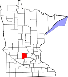 | |
| Townships | ||
| Unincorporated communities | ||
| Footnotes | ‡This populated place also has portions in an adjacent county or counties | |