Litchfield, Minnesota
| Litchfield, Minnesota | |
|---|---|
| City | |
|
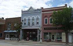
The Litchfield Commercial Historic District. | |
| Nickname(s): Litch | |
 Location of the city of Litchfield within Meeker County in the state of Minnesota | |
| Coordinates: 45°7′N 94°32′W / 45.117°N 94.533°W | |
| Country | United States |
| State | Minnesota |
| County | Meeker |
| Area[1] | |
| • Total | 5.40 sq mi (13.99 km2) |
| • Land | 4.43 sq mi (11.47 km2) |
| • Water | 0.97 sq mi (2.51 km2) |
| Elevation | 1,129 ft (344 m) |
| Population (2010)[2] | |
| • Total | 6,726 |
| • Estimate (2012[3]) | 6,671 |
| • Density | 1,518.3/sq mi (586.2/km2) |
| Time zone | Central (CST) (UTC-6) |
| • Summer (DST) | CDT (UTC-5) |
| ZIP code | 55355 |
| Area code(s) | 320 |
| FIPS code | 27-37448[4] |
| GNIS feature ID | 0646743[5] |
| Website | www.ci.litchfield.mn.us |
Litchfield is a city in and the county seat of Meeker County, Minnesota, United States.[6] The population was 6,726 at the 2010 census.[7]
History
Litchfield was platted in 1869 when the railroad was extended to that point.[8] The city is named after the family English capitalist E. Darwin Litchfield, a major stockholder of the Saint Paul and Pacific Railroad.[8] A post office has been in operation at Litchfield since 1869.[9] Litchfield was incorporated in 1872.[8]
Geography
According to the United States Census Bureau, the city has a total area of 5.40 square miles (13.99 km2), of which 4.43 square miles (11.47 km2) is land and 0.97 square miles (2.51 km2) is water.[1]
U.S. Highway 12 and Minnesota State Highways 22 and 24 are three of the main routes in the city.
Demographics
| Historical population | |||
|---|---|---|---|
| Census | Pop. | %± | |
| 1870 | 353 | — | |
| 1880 | 1,250 | 254.1% | |
| 1890 | 1,899 | 51.9% | |
| 1900 | 2,280 | 20.1% | |
| 1910 | 2,333 | 2.3% | |
| 1920 | 2,790 | 19.6% | |
| 1930 | 2,880 | 3.2% | |
| 1940 | 3,920 | 36.1% | |
| 1950 | 4,608 | 17.6% | |
| 1960 | 5,078 | 10.2% | |
| 1970 | 5,262 | 3.6% | |
| 1980 | 5,904 | 12.2% | |
| 1990 | 6,041 | 2.3% | |
| 2000 | 6,562 | 8.6% | |
| 2010 | 6,574 | 0.2% | |
| Est. 2015 | 6,657 | [10] | 1.3% |
| U.S. Decennial Census | |||
2010 census
As of the census[2] of 2010, there were 6,726 people, 2,747 households, and 1,749 families residing in the city. The population density was 1,518.3 inhabitants per square mile (586.2/km2). There were 2,930 housing units at an average density of 661.4 per square mile (255.4/km2). The racial makeup of the city was 95.8% White, 0.5% African American, 0.1% Native American, 0.1% Asian, 2.6% from other races, and 0.8% from two or more races. Hispanic or Latino of any race were 7.2% of the population.
There were 2,747 households of which 30.8% had children under the age of 18 living with them, 48.4% were married couples living together, 10.7% had a female householder with no husband present, 4.6% had a male householder with no wife present, and 36.3% were non-families. 32.0% of all households were made up of individuals and 16.1% had someone living alone who was 65 years of age or older. The average household size was 2.37 and the average family size was 2.98.
The median age in the city was 39.6 years. 24.9% of residents were under the age of 18; 7.3% were between the ages of 18 and 24; 23.9% were from 25 to 44; 25.6% were from 45 to 64; and 18.4% were 65 years of age or older. The gender makeup of the city was 48.8% male and 51.2% female.
Notable people
- Bernie Bierman – Minnesota Gophers Coach, won five national championships and seven Big Ten Titles.
- John Carlson, Jr. – Minnesota Viking, previously Seattle Seahawk - Tight End
- Herbert W. Chilstrom - Presiding Bishop (1987–95) of the Evangelical Lutheran Church in America.
- John W. Foss - General, US Army (Ret.) United States Army four-star general and former commander of the United States Army Training and Doctrine Command.
- Anne Hanson - First living woman in the history of the 42nd Infantry Division to receive a Purple Heart.
- Dave Klug – Kansas City Chiefs - Linebacker
- Dorothea S. Kopplin – Author of "Something To Live By", teacher, and 1949 Minnesota Mother of the Year. Owner of the "Rosemary Home", her last wish was to provide housing to nursing students and business women in memory of her daughter Rosemary who died at the age of six from leukemia.
- Ann D. Montgomery - U.S. Federal District Court Judge
- Ole Halverson Ness - Founded the first Lutheran church (St. Johannes' Lutheran Congregation, now known as Ness Lutheran Church) and school in Meeker County. Ole paid the first teacher, John Blackwell to teach his children and any others that wanted to attend school in his home. The town of Litchfield was originally named Ripley after Dr. Frederick Ripley, but was then changed to "Ness" in honor of Ole Halverson Ness, Esq. Ness was part of the Action Burial Party who buried the first five victims of the U.S. Dakota War on the Ness Lutheran Church grounds. Having been a six-year veteran of the Norwegian Army, Ole supervised the construction of the Forest City Stockade which provided shelter to 240 settlers during the U.S. Dakota War.
- William A. Nolen – (1928-1986) Surgeon and Author that wrote a syndicated medical advice column that appeared in McCall's magazine for many years. His best known book, "The Making of a Surgeon", was written in 1970. Appeared multiple times on Johnny Carson's Tonight Show.
- Joe Paddock - Poet, oral historian and environmental writer. His books include: Soil and Survival, Handful of Thunder: A Prairie Cycle, A Sort of Honey, Boar's Dance, Keeper of the Wild, Earth Tongues, and Circle of Stones.[11]
- Nancy Paddock - Poet and environmental writer who has also written plays. Her book "Trust the Wild Heart" was a finalist for the 2006 Minnesota Book Award in poetry.
- Wally Pikal - Born in 1927. Entertainer and musician. MN Music Hall of Fame Inductee, resident of Litchfield, MN for more than 30 years. During his career, Pikal has been on The Tonight Show, The Mike Douglas Show and Bozo the Clown. Played with such notables as Frank Sinatra Jr, Conway Twitty, and Victor Borge.
- Eddie "King" Roeser - Founding member, Bass Guitar & Vocals, Original member of Urge Overkill, an alternative rock band. Their cover of Neil Diamond's song "Girl, You'll Be a Woman Soon" appeared prominently in the movie Pulp Fiction, and became a hit in 1994.
- Michael Shaw - Minnesota Music Hall of Fame, Mid-America Music Hall of Fame, first open heart surgery survivor, operation by Drs. Lillihei and Lewis.
- Terry Shaw - Minnesota Music Hall of Fame and author of Terry Tales and Terry Tales 2 (books on the history of Litchfield).
- Gale Sondergaard – (1899–1985) Academy Award winning actress 1936 (first woman to win a best supporting actress award)
- Hester Sondergaard – (1903–1994) Starred in Hollywood films Naked City, Seeds of Freedom and Jigsaw. Well known New York radio character and Broadway actress. Worked for CBS, NBC and Arch Oboler's Radio Shows. Sister of Gale Sondergaard.
- Dan Sperry - Magician, illusionist, anti-conjuror. Born in August 1985, his signature style of magic is called "Shock Illusion" where he performs cutting edge magic incorporating razor blades, needles; broken glass, voodoo and industrial shredders.
- Mary Angell Lamb Tacot – (XXXX–1990) Broadway star (stage name Mary Angell) who traveled with a theater company in 1924.
- Floyd Warta - LHS Drama teacher, starred in state and national TV ads. Played Santa for Arctic Cat ads.
- Andrew Soucek, Blake Steil and Erik Bergstrom - Hosts of the podcast "Wrestling With Friends". Wrestling With Friends is the 7,438th most popular wrestling podcast in the United States. They are known for doing bad impressions of Vince Russo, Mr. Wrestling 2 and Jim Ross. They will often yell nonsensical things pretending to be Rick Steiner, and work in the names of various USA network shows. Despite its low ratings, it has a hardcore fanbase consisting of two people.
References
- 1 2 "US Gazetteer files 2010". United States Census Bureau. Retrieved 2012-11-13.
- 1 2 "American FactFinder". United States Census Bureau. Retrieved 2012-11-13.
- ↑ "Population Estimates". United States Census Bureau. Retrieved 2013-05-28.
- ↑ "American FactFinder". United States Census Bureau. Retrieved 2008-01-31.
- ↑ "US Board on Geographic Names". United States Geological Survey. 2007-10-25. Retrieved 2008-01-31.
- ↑ "Find a County". National Association of Counties. Retrieved 2011-06-07.
- ↑ "2010 Census Redistricting Data (Public Law 94-171) Summary File". American FactFinder. U.S. Census Bureau, 2010 Census. Retrieved 23 April 2011.
- 1 2 3 Upham, Warren (1920). Minnesota Geographic Names: Their Origin and Historic Significance. Minnesota Historical Society. p. 340.
- ↑ "Meeker County". Jim Forte Postal History. Retrieved 21 July 2015.
- ↑ "Annual Estimates of the Resident Population for Incorporated Places: April 1, 2010 to July 1, 2015". Retrieved July 2, 2016.
- ↑ Interview with Peter Shea, May 2014 http://ias.umn.edu/2014/05/10/paddock/
External links
| Wikimedia Commons has media related to Litchfield, Minnesota. |
- Litchfield Chamber of Commerce
- Litchfield Independent Review newspaper site
- Meeker County Historical Society Meeker County Historical Society
Coordinates: 45°7′N 94°32′W / 45.117°N 94.533°W
Municipalities and communities of Meeker County, Minnesota, United States | ||
|---|---|---|
| Cities | 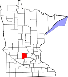 | |
| Townships | ||
| Unincorporated communities | ||
| Footnotes | ‡This populated place also has portions in an adjacent county or counties | |