Tubac, Arizona
| Tubac, Arizona | |
|---|---|
| Census-designated place | |
|
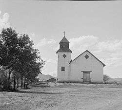
St. Ann's Church, Tubac, 1937 | |
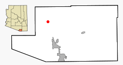 Location in Santa Cruz County and the state of Arizona | |
 18th century map of Tubac and surroundings | |
| Coordinates: 31°37′32″N 111°3′7″W / 31.62556°N 111.05194°WCoordinates: 31°37′32″N 111°3′7″W / 31.62556°N 111.05194°W | |
| Country | United States |
| State | Arizona |
| County | Santa Cruz |
| Area | |
| • Total | 10.8 sq mi (28.0 km2) |
| • Land | 10.8 sq mi (28.0 km2) |
| • Water | 0.0 sq mi (0.0 km2) |
| Elevation | 3,209 ft (978 m) |
| Population (2010) | |
| • Total | 1,191 |
| • Density | 110/sq mi (43/km2) |
| Time zone | MST (no DST) (UTC-7) |
| ZIP codes | 85640, 85646 |
| Area code(s) | 520 |
| FIPS code | 04-75940 |
| GNIS feature ID | 0035489 |
Tubac is a census-designated place (CDP) in Santa Cruz County, Arizona, United States. The population was 1,191 at the 2010 census.[1] The place name "Tubac" is an English borrowing from a Hispanicized form of the O'odham name, which translates into English as "rotten". The original O'odham name is written Cuwak. The first syllable is accented. When first taken into Spanish speech, it was spelled Tubaca. Finally over time the last "a" was dropped.[2] Tubac is situated on the Santa Cruz River.
Tubac was the original Spanish colonial garrison in Arizona. It was depopulated during the O'odham Uprising in the 18th century. During the 19th century, the area was repopulated by miners, farmers and ranchers, but the town of Tubac is best known today as an artists' colony.
Geography
Tubac is located at 31°37′32″N 111°3′7″W / 31.62556°N 111.05194°W (31.625462, -111.051921).[3]
According to the United States Census Bureau, the CDP has a total area of 10.8 square miles (28.0 km2), all of it land.[1]
History
Established in 1752 as a Spanish presidio, the first Spanish colonial garrison in what is now Arizona, Tubac was one of the stops on the Camino Real (the "Royal Road") from Mexico to the Spanish settlements in California.
Tubac's most famous Spanish resident was Juan Bautista de Anza. While stationed at Tubac (1760–1776), de Anza built the chapel of Santa Gertrudis, the foundations of which lie beneath today's St. Ann's Church.
Apaches attacked the town repeatedly in the 1840s, forcing the Sonoran Mexicans to abandon both Tumacacori and Tubac.
Tubac was the scene of a four-day siege in 1861, between Tubac's male population, Confederate militia and Apache warriors.[4]
In the 1930s - 1960s Tubac became an art colony. Painter Dale Nichols opened an art school in the small desert village in 1948 and restored some of Tubac's historic buildings. Students included watercolorist Al Romo and sculptor Bob Brisley. In 1961 the Santa Cruz Valley Art Association was formed with 80 members and the group founded the Tubac Festival of the Arts in 1964. [5]
Other significant artist in the Village included Sophie and Harwood Steiger, Hal Empie, and Hugh Cabot.
Attractions
The remains of the old Spanish presidio are preserved by Tubac Presidio State Historic Park. The park also features a regional museum, an underground archeology display, and other historic buildings.
Demographics
2010 census
As of the census of 2010, there were 1,191 people residing in Tubac. The racial makeup of Tubac was 76.67% non-Hispanic White, 0.59% Native American, 0.42% Black or African American, 0.59% Asian, 6.47% from other races, and 1.09% from two or more races. 20.65% of the population were Hispanic or Latino of any race.
In Tubac 1.5% of the population was age 0-4, 4.7% from 5 to 17, 50.97% from 18 to 64, and 42.49% 65 years of age or older. The population of Tubac is 52.39% female and 47.61% male.
2000 census
As of the census[6] of 2000, there were 949 people, 481 households, and 303 families residing in the CDP. The population density was 115.9 people per square mile (44.8/km²). There were 569 housing units at an average density of 69.5 per square mile (26.9/km²). The racial makeup of the CDP was 88.72% White, 1.16% Native American, 0.42% Asian, 8.96% from other races, and 0.74% from two or more races. 18.23% of the population were Hispanic or Latino of any race.
There were 481 households out of which 12.5% had children under the age of 18 living with them, 59.3% were married couples living together, 2.9% had a female householder with no husband present, and 36.8% were non-families. 32.6% of all households were made up of individuals and 21.0% had someone living alone who was 65 years of age or older. The average household size was 1.97 and the average family size was 2.45.
In the CDP the population was spread out with 12.3% under the age of 18, 2.5% from 18 to 24, 12.1% from 25 to 44, 37.8% from 45 to 64, and 35.2% who were 65 years of age or older. The median age was 58 years. For every 100 females there were 92.5 males. For every 100 females age 18 and over, there were 89.5 males.
The median income for a household in the CDP was $39,444, and the median income for a family was $59,375. Males had a median income of $36,528 versus $30,268 for females. The per capita income for the CDP was $46,643. About 2.1% of families and 6.6% of the population were below the poverty line, including none of those under age 18 and 7.9% of those age 65 or over.
References
- 1 2 "Geographic Identifiers: 2010 Demographic Profile Data (G001): Tubac CDP, Arizona". U.S. Census Bureau, American Factfinder. Retrieved December 4, 2012.
- ↑ Dobyns, H.F. (1959). "''Tubac'' ''Through Four Centuries'': ''An Historical Resume and Analysis'', The Arizona State Parks Board". Parentseyes.arizona.edu. Retrieved 2013-11-29.
- ↑ "US Gazetteer files: 2010, 2000, and 1990". United States Census Bureau. 2011-02-12. Retrieved 2011-04-23.
- ↑ Walker A. Tompkins, Santa Barbara History Makers. McNally & Loftin, 1983. p. 105. ISBN 0-87461-059-1
- ↑ Tubac Center of the Arts , History. 2016 http://tubacarts.org/about-us/mission-history/
- ↑ "American FactFinder". United States Census Bureau. Retrieved 2008-01-31.
External links
![]() Media related to Tubac, Arizona at Wikimedia Commons
Media related to Tubac, Arizona at Wikimedia Commons
- Henry F. Dobyns, "Tubac Through Four Centuries"
- Tubac Presidio State Historic Park
- "Through Our Parents' Eyes: History & Culture of Southern Arizona"
Municipalities and communities of Santa Cruz County, Arizona, United States | ||
|---|---|---|
| City |  | |
| Town | ||
| CDPs | ||
| Populated places |
| |
| Ghost towns | ||