M-10 (Michigan highway)
| |||||||
|---|---|---|---|---|---|---|---|
|
M-10 highlighted in red | |||||||
| Route information | |||||||
| Maintained by MDOT | |||||||
| Length: | 22.881 mi[1] (36.823 km) | ||||||
| Existed: | 1986 – present | ||||||
| Major junctions | |||||||
| South end: |
| ||||||
| |||||||
| North end: | Orchard Lake Road in West Bloomfield Township | ||||||
| Location | |||||||
| Counties: | Wayne, Oakland | ||||||
| Highway system | |||||||
| |||||||

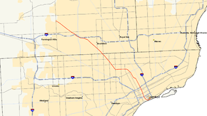
M-10 is a north–south state trunkline highway in the Metro Detroit area of Michigan in the United States. The southernmost portion follows Jefferson Avenue in downtown Detroit, and the southern terminus is at the intersection of Jefferson and M-3 (Randolph Street) next to the entrance to the Detroit–Windsor Tunnel. The northern terminus is in West Bloomfield Township at the intersection with Orchard Lake Road. The highway has several names as it runs through residential and commercial areas of the west side of Detroit and into the suburb of Southfield. It is called the John C. Lodge Freeway, The Lodge, James Couzens Highway and Northwestern Highway.
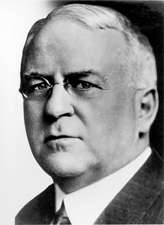
M-10 was built in segments through the late 1950s and early 1960s. It carried several different names before the entire route was finally officially named the John C. Lodge Freeway in 1987. The freeway has carried a few other highway designations. The southern segment was part of US Highway 12 (US 12) and the whole thing was later renumbered Business Spur Interstate 696 (BS I-696). From 1970 until 1986, it was part of US 10, and the freeway has been M-10 since. The non-freeway segment that runs between I-696 in Southfield and Orchard Lake Road was previously numbered M-4. M-10 was named after John C. Lodge, an influential Detroiter and Mayor of Detroit from 1927–28.
Route description
Running about 22.8 miles (36.7 km) in the Metro Detroit area, M-10 runs roughly northwest–southeast from Downtown Detroit into the northern suburbs in Oakland County.[2] The entire length of the highway is listed as a part of the National Highway System,[3] a system of roads importance to the nation's economy, defense and mobility.[4] As a state trunkline highway, the roadway is maintained by the Michigan Department of Transportation (MDOT), and it includes approximately 18.5 miles (29.8 km) of freeway.[1] M-10 has six lanes from Detroit to Inkster Road in Farmington Hills, where it drops to four; a few segments have eight lanes for short distances between interchanges.[5] According to the department, 28,964 vehicles use M-10 on average near on Jefferson Avenue in Detroit, and 139,800 vehicles do so between US 24 (Telegraph Road) and Lahser Road in Southfield, the lowest and highest traffic counts along the highway in 2013, respectively.[6]
Detroit

M-10 starts at the corner of Jefferson Avenue and Randolph Street in Downtown Detroit, an intersection that also marks the southern end of M-3 and the western end of Business Spur I-375. This intersection is also the access to the Detroit–Windsor Tunnel between the Renaissance Center and the Old Mariners' Church. From here, M-10 runs west-southwesterly parallel to the Detroit River on Jefferson Avenue past Hart Plaza. At the intersection with Woodward Avenue, M-10 transitions onto the John C. Lodge Freeway, which runs under Cobo Center, home of the North American International Auto Show each January. The freeway turns north-northwesterly and away from the Detroit River next to Joe Louis Arena. North of the Cobo Center curve, M-10 forms the boundary between Downtown Detroit to the east and the Corktown neighborhood to the west. The freeway has a pair of service drives as it leaves the commercial areas near the MGM Grand Detroit and the interchange with I-75 (Fisher Freeway).[2][5]
North of I-75, M-10 forms the border between North Corktown (west) and Midtown Detroit (east). The freeway passes the MotorCity Casino at at the interchange with Grand River Avenue. The rest of its route in the part of the city passes through residential zones. Near the interchange with I-94 (Edsel Ford Freeway), M-10 passes the campus of Wayne State University.[2][5] M-10 intersects I-94 at the first freeway-to-freeway interchange in the United States.[7] North of I-94, the Lodge Freeway is the border between the West Side and New Center . This area is residential on either side of the freeway north of the campus of the Henry Ford Hospital. North of Clairmont Avenue, M-10 curves to the northwest before resuming its north-northwesterly course near Chicago Boulevard. North of Webb Avenue, the freeway follows the western city limits of Highland Park, an enclave within the city of Detroit. M-10 intersects M-8 where it transitions between Davison Avenue and the Davison Freeway on the western edge of Highland Park before the Lodge Freeway curves around to run due west.[2][5]
M-10 runs for about two miles (3.2 km) on this due westward course before it intersects Wyoming Avenue and turns northwest. The frontage roads change names from John C. Lodge Service Drive to James Couzens Freeway at the Wyoming Avenue interchange. The freeway continues for another 3 1⁄2 miles (5.6 km) with interchanges for local streets in this part of Detroit, including 7 Mile Road. At the interchange with M-102 (8 Mile Road), the freeway crosses out of Detroit and Wayne County into Southfield in Oakland County.[2][5]
Oakland County

The service drives change names again to Northwestern Highway upon crossing into Oakland County. The east side of M-10 is flanked by the Northland Shopping Center and a campus of Oakland Community College; the west side is residential. About 1 1⁄4 miles (2.0 km) into Southfield, M-10 intersects the northern end of M-39 (Southfield Freeway) and 9 Mile Road. The adjacent properties are mostly residential, but there are some commercial areas centered around the various Mile Roads, such as the campus of Lawrence Technological University at 10 Mile Road.[2][5] Near Lahser and 11 Mile roads, M-10 meets I-696 (Reuther Freeway) and US 24 (Telegraph Road) in a complex interchange called the Mixing Bowl.[8] This interchange spans over two miles (3.2 km) near the American Center. The carriageways for I-696 run in the median of M-10 while partial interchanges connect to Lahser and Franklin roads on either end of the various ramps that connect to I-696 and US 24.[2][5]
Northwest of this interchange, M-10 transitions to a boulevard with Michigan lefts. Called just Northwestern Highway, M-10 runs through suburban residential areas of Southfield. At the intersection with Inkster Road, the highway clips the southwest corner of the city of Franklin and enters the northeastern corner of Farmington Hills. The roadway is lined with commercial properties while just behind them are residential subdivisions and two golf courses. At the intersection with 14 Mile Road, Northwestern Highway crosses into West Bloomfield Township, and 1⁄4 mile (0.40 km) further on, the highway ends at Orchard Lake Road.[2][5]
History
Previous designations
| |
|---|---|
| Location: | Ohio state line–Mackinaw City |
| Existed: | c. July 1, 1919[9]–November 11, 1926[10] |
In 1919, the state numbered its highways for the first time.[11] In the initial allocation of numbers, M-10 was assigned to a highway that started at the Ohio state line south of Monroe, ran northeasterly along Telegraph Road into Dearborn and turned easterly into Detroit. From there, the highway turned north along Woodward Avenue through Pontiac and Dixie Highway through Flint and Saginaw to Bay City. Then M-10 ran along the Saginaw Bay to Standish and turned to follow the Lake Huron shoreline, with some substantial deviations inland. The highway generally followed the lakeshore as far north as Alpena and Rogers City, and from there, M-10 ran due west through Onaway before turning north into Cheboygan. The last section of M-10 followed the Lake Huron shoreline to Mackinaw City, where it terminated.[9] This designation lasted until November 11, 1926, when the United States Numbered Highway System was created.[12] In Michigan's initial allocation of highways, four new designations replaced M-10: US 24 from the state line north to Dearborn, US 112 between Dearborn and Detroit, US 10 from Detroit to Saginaw, and US 23 from Saginaw to Mackinaw City.[10] At the time, no M-10 designation was reassigned to any other roads.[13]
| |
|---|---|
| Location: | Grand Blanc–Mt. Morris |
| Length: | 14.767 mi[1] (23.765 km) |
| Existed: | 1929[14][15]–1941[16][17] |
The second iteration of M-10 was designated in 1929 on a much shorter segment of the original M-10 through the Flint area, serving as a business connection for the city as the through route, US 10, bypassed it on the east.[14][15] It was later redesignated as Business US 10 (Bus. US 10) in 1941,[16][17] and then as Bus. M-54 in 1962[18][19] before being turned back to local control in 1974.[20][21]
Current designation
During the 1950s, the Lodge Freeway was proposed to run from Detroit as far as the Fenton–Clio Expressway (US 23) at Fenton.[22] The intersection with the Edsel Ford Freeway, next to Wayne State University was built in 1953 and was the first full freeway-to-freeway interchange built in the United States.[23][24] The freeway was dedicated on November 7, 1957,[25] and opened without any state trunkline designation between downtown and the Wyoming Curve.[26] The section from the Edsel Ford Freeway (now I-94) into downtown Detroit was designated as US 12 by the middle of 1960.[27]
| |
|---|---|
| Location: | Detroit–Southfield |
| Length: | 17.538 mi[1] (28.225 km) |
| Existed: | 1962[28][29]–1970[30][31] |
The freeway was then redesignated Business Spur I-696 (BS I-696) in 1962,[28][29] and the next year the freeway was extended northwesterly along James Couzens Highway and Northwestern Highway into Southfield,[29][32] connecting with the completed first phase of I-696 that opened in 1963-64.[33] That designation remained until 1970 when US 10 was shifted off Woodward Avenue to follow the Lodge Freeway between downtown Detroit and Telegraph Road, replacing the BS I-696 designation.[30][31]
| |
|---|---|
| Location: | Farmington Hills–Southfield |
| Length: | 4.687 mi[1] (7.543 km) |
| Existed: | 1979[34][35]–1986[36][37] |
An extension to the Northwestern Highway was again proposed in 1966 to connect with the proposed I-275 extension.[38] The I-275 project was then cancelled in 1977.[39] The section of Northwestern Highway under state control between the West Bloomfield Township–Farmington Hills border into Southfield was numbered M-4 in 1979.[34][35]
The Michigan Department of Transportation (MDOT) petitioned the American Association of State Highway and Transportation Officials in the mid-1980s to truncate US 10 to Bay City. The request was approved on October 11, 1985,[40] and the signage was changed the next year. After the change, the Lodge Freeway was redesignated M-10. The non-freeway Northwestern Highway, until then designated M-4, was also renumbered as M-10. The southernmost portion of the Lodge Freeway was also initially redesignated as a portion of BS I-375 from I-75 south.[36][37] By the next year however, the southern end of M-10 was moved to the corner of Jefferson and Randolph, placing all of the Lodge Freeway as part of M-10.[37][41]
From 2006 to 2007, the Lodge underwent major reconstruction to ease traffic congestion in the metro area, temporarily closing down much of the freeway.[42] The $133 million project (equivalent to $155 million in 2015[43]) included concrete pavement reconstruction and rehabilitation, new barrier walls, repairs or replacements to 50 bridges, upgrades to 22 ramps, utility upgrades, and replacement of freeway signs between Lahser Road in Southfield and Jefferson Avenue in Detroit.[44]
Memorial highway names
Starting in 1924, officials in southeastern Michigan proposed building a highway from Detroit to run northwesterly across the state to Ludington, bisecting the angle created by Woodward and Grand River avenues. This roadway was named Northwestern Highway when it was built in 1929 to an endpoint at 14 Mile Road. Further construction on Northwestern Highway was halted by the Great Depression.[45]
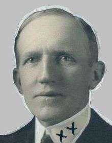
The freeway segment northwest of Wyoming Avenue to the county line was previously known as James Couzens Highway after the street it replaced. That street was named after the death of James J. Couzens. Couzens was a former Commissioner of Detroit's Department of Street Railways from 1913 through 1915, after which he served as Police Commissioner from 1916 until 1918. He was Mayor of Detroit from 1919 until 1922 and United States Senator from Michigan from 1922 until his death on October 22, 1936. During his years of public service, he is said not to have accepted a salary, giving it all to charity. After his death, Detroit renamed its section of Northwestern Highway after Couzens.[45]
John C. Lodge was a member of the constitutional convention which drafted the Michigan Constitution of 1908, a former member of the Michigan Legislature and Detroit alderman and councilman. He later served as Mayor of Detroit in 1918–1919 before returned to the City Common Council from 1932 to 1947. He was then elected to the Wayne County Board of Supervisors from 1948 until 1950. In total, he held elective office longer than anyone in city history. He died on February 6, 1950, and the future Lodge Freeway was named in his honor on January 20, 1953.[45] The entire freeway, including segments previously named for James Couzens and the Northwestern Highway was named the John C. Lodge Freeway in 1987, although the service drives retained their original names.[46]
Exit list
| County | Location | mi[1] | km | Exit | Destinations | Notes |
|---|---|---|---|---|---|---|
| Wayne | Detroit | 0.000 | 0.000 | Detroit–Windsor Tunnel | Jefferson Avenue continues east as BS I-375 | |
| 0.590 | 0.950 | 1A | Jefferson Avenue – Joe Louis Arena | Joe Louis Parking Center & Riverfront Apartments; freeway begins | ||
| 0.722 | 1.162 | 1B | Larned Street – Cobo Center | Southbound exit only | ||
| 1.131 | 1.820 | 1C | Howard Street – Cobo Roof | Southbound exit and northbound entrance | ||
| 1.533 | 2.467 | 2B | Bagley Avenue | Southbound exit and northbound entrance | ||
| 1.775 | 2.857 | 2A | Exit 49 on I-75; includes southbound exit and northbound, southbound entrances for Trumbull Avenue | |||
| 2.052 | 3.302 | 2C | Grand River Avenue | Southbound exit and northbound entrance | ||
| 2.919 | 4.698 | 3 | Forest Avenue, Warren Avenue | |||
| 3.127 | 5.032 | 4 | Signed as exits 4A (east) and 4B (west); exit 215 on I-94 | |||
| 3.737 | 6.014 | 4C | Milwaukee Avenue, West Grand Boulevard | |||
| 4.332 | 6.972 | 5A | Pallister Avenue | Southbound exit and northbound entrance | ||
| 4.751 | 7.646 | 5B | Clairmount Avenue | Northbound exit and southbound entrance | ||
| 5.391 | 8.676 | 5C | Hamilton Avenue, Chicago Boulevard | Hamilton Avenue signed northbound only | ||
| 5.652 | 9.096 | 6A | Webb Avenue | No southbound exit | ||
| 6.051 | 9.738 | 6B | Elmhurst Avenue | Southbound exit only | ||
| 6.194 | 9.968 | 7A | Glendale Avenue | Northbound exit and southbound entrance | ||
| Detroit–Highland Park city line | 6.406– 6.777 | 10.309– 10.907 | 7 | Signed as exits 7B (east) and 7C (west) northbound and 7B (east) southbound; no access from southbound M-10 to westbound M-8 or eastbound M-8 to northbound M-10 | ||
| Detroit | 7.453 | 11.994 | 8 | Linwood Avenue | ||
| 8.107 | 13.047 | 9 | Livernois Avenue | |||
| 7.571 | 12.184 | — | Greenlawn Street | Former northbound exit and southbound entrance[47] | ||
| 9.146 | 14.719 | 10 | Wyoming Avenue | |||
| 9.868 | 15.881 | 11 | Meyers Road, McNichols Road | Northbound exit and southbound entrance | ||
| 11.337 | 18.245 | 12 | 7 Mile Road | |||
| Wayne–Oakland county line | Detroit–Southfield city line | 12.872 | 20.715 | 13 | 8 Mile Road is the city and county line | |
| Oakland | Southfield | 13.817 | 22.236 | 14 | 9 Mile Road, Northland Center | Signed as exits 14A (Northland) and 14B (9 Mile Road); complete access to Northland Center, no entrances from 9 Mile Road; 14B exit is north of 14C southbound; 14A and 14B ramps are combined northbound |
| 14.310 | 23.030 | 14C | Southfield Road north | Exit 15 on M-39; signed as Southfield Road northbound only; directional access (northbound to northbound or southbound to southbound) only; northern terminus of M-39 | ||
| 15.629 | 25.152 | 15 | Evergreen Road, 10 Mile Road | |||
| 16.787 | 27.016 | 16 | Lahser Road | |||
| 17.538 | 28.225 | 17 | Exit 10 on I-696; southbound exit only | |||
| 18.194 | 29.280 | 18 | Signed as exits 18A (north) and 18B (south); I-696 is located in the median of M-10 | |||
| 18.562 | 29.873 | 18C | Exit 8 on I-696; northbound exit only; freeway ends | |||
| West Bloomfield Township | 22.881 | 36.823 | Orchard Lake Road | |||
| 1.000 mi = 1.609 km; 1.000 km = 0.621 mi | ||||||
See also
 Metro Detroit portal
 Michigan Highways portal
References
- 1 2 3 4 5 6 Michigan Department of Transportation & Michigan Center for Shared Solutions and Technology Partnerships (2009). MDOT Physical Reference Finder Application (Map). Michigan Department of Transportation. Retrieved March 23, 2010.
- 1 2 3 4 5 6 7 8 Michigan Department of Transportation (2014). Pure Michigan: State Transportation Map (Map). c. 1:158,400. Lansing: Michigan Department of Transportation. Detroit Area inset. §§ C8–F11. OCLC 42778335, 900162490.
- ↑ Michigan Department of Transportation (2005). National Highway System: Detroit Urbanized Area (PDF) (Map). Scale not given. Lansing: Michigan Department of Transportation. Retrieved October 7, 2008.
- ↑ Natzke, Stefan; Neathery, Mike & Adderly, Kevin (August 26, 2010). "What is the National Highway System?". National Highway System. Federal Highway Administration. Retrieved December 12, 2010.
- 1 2 3 4 5 6 7 8 Google (April 10, 2015). "Overview Map of M-10" (Map). Google Maps. Google. Retrieved April 10, 2015.
- ↑ Bureau of Transportation Planning (2008). "Traffic Monitoring Information System". Michigan Department of Transportation. Retrieved April 16, 2015.
- ↑ Naber, MaryAnn (November 1, 2006). "Final List of Nationally and Exceptionally Significant Features of the Federal Interstate Highway System". Federal Highway Administration. Retrieved August 20, 2016.
- ↑ Staff (Summer 2007). "MITA Presents Michigan Construction Quality Partnership Awards" (PDF). Cross-Section. Michigan Infrastructure and Transportation Association. p. 11. Retrieved August 30, 2012.
- 1 2 Michigan State Highway Department (July 1, 1919). State of Michigan (Map). Scale not given. Lansing: Michigan State Highway Department. Lower Peninsula sheet. OCLC 15607244.
- 1 2 Bureau of Public Roads & American Association of State Highway Officials (November 11, 1926). United States System of Highways Adopted for Uniform Marking by the American Association of State Highway Officials (Map). 1:7,000,000. Washington, DC: U.S. Geological Survey. OCLC 32889555. Retrieved November 7, 2013 – via University of North Texas Libraries.
- ↑ "Michigan May Do Well Following Wisconsin's Road Marking System". The Grand Rapids Press. September 20, 1919. p. 10. OCLC 9975013.
- ↑ McNichol, Dan (2006). The Roads that Built America. New York: Sterling. p. 74. ISBN 1-4027-3468-9.
- ↑ Michigan State Highway Department (December 1, 1926). Official Highway Condition Map (Map). [c. 1:823,680]. Lansing: Michigan State Highway Department.
- 1 2 Michigan State Highway Department (May 1, 1929). Official Highway Service Map (Map). [c. 1:810,000]. Lansing: Michigan State Highway Department. OCLC 12701195, 79754957.
- 1 2 Michigan State Highway Department & H.M. Gousha (January 1, 1930). Official Highway Service Map (Map). [c. 1:810,000]. Lansing: Michigan State Highway Department. OCLC 12701195, 79754957.
- 1 2 Michigan State Highway Department & Rand McNally (March 21, 1941). Official Michigan Highway Map (Map) (Spring ed.). [c. 1:850,000]. Lansing: Michigan State Highway Department. § K12. OCLC 12701143.
- 1 2 Michigan State Highway Department & Rand McNally (July 1, 1941). Official Michigan Highway Map (Map) (Summer ed.). [c. 1:850,000]. Lansing: Michigan State Highway Department. § K12. OCLC 12701143.
- ↑ Michigan State Highway Department (1962). Official Highway Map (Map). [c. 1:918,720]. Lansing: Michigan State Highway Department. §§ K12–L12. OCLC 12701120, 173191490.
- ↑ Michigan State Highway Department (1963). Official Highway Map (Map). [c. 1:918,720]. Lansing: Michigan State Highway Department. §§ K12–L12. OCLC 12701120.
- ↑ Michigan Department of State Highways and Transportation (1974). Michigan, Great Lake State: Official Transportation Map (Map). c. 1:918,720. Lansing: Michigan Department of State Highways and Transportation. § K12. OCLC 12701177, 83138602.
- ↑ Michigan Department of State Highways and Transportation (1975). Michigan, Great Lake State: Official Transportation Map (Map). c. 1:918,720. Lansing: Michigan Department of State Highways and Transportation. § K12. OCLC 12701177, 320798754.
- ↑ Greenwood, Tom (January 28, 1999). "M-5 'Haggerty Connector' Work to Be Done by 2001". The Detroit News.
- ↑ Naber, MaryAnn (November 1, 2006). "Final List of Nationally and Exceptionally Significant Features of the Federal Interstate Highway System". Federal Highway Administration. Retrieved February 27, 2007.
- ↑ Michigan Department of Transportation (n.d.). "I-94 EB / I-94 Ramp to M-10". Michigan Department of Transportation. Retrieved August 20, 2016.
- ↑ John C. Lodge Expressway Dedication Committee (1957). John C. Lodge Expressway Dedication Program. Detroit: John C. Lodge Expressway Dedication Committee. OCLC 34869718.
- ↑ Michigan State Highway Department (1958). Official Highway Map (Map). Scale not given. Lansing: Michigan State Highway Department. Detroit inset. OCLC 12701120, 51856742. (Includes all changes through July 1, 1958)
- ↑ Michigan State Highway Department (1960). Official Highway Map (Map). Scale not given. Lansing: Michigan State Highway Department. Detroit inset. OCLC 12701120, 81552576. (Includes all changes through July 1, 1960)
- 1 2 Michigan State Highway Department (1962). Official Highway Map (Map). Scale not given. Lansing: Michigan State Highway Department. Detroit inset. OCLC 12701120, 173191490.
- 1 2 3 Michigan State Highway Department (1963). Official Highway Map (Map). Scale not given. Lansing: Michigan State Highway Department. Detroit inset. OCLC 12701120.
- 1 2 Michigan Department of State Highways (1970). Michigan, Great Lake State: Official Highway Map (Map). c. 1:158,400. Lansing: Michigan Department of State Highways. Detroit and Vicinity inset. §§ A6–E9. OCLC 12701120.
- 1 2 Michigan Department of State Highways (1971). Michigan, Great Lake State: Official Highway Map (Map). c. 1:158,400. Lansing: Michigan Department of State Highways. Detroit and Vicinity inset. §§ A6–E9. OCLC 12701120, 77960415.
- ↑ Michigan State Highway Department (1964). Official Highway Map (Map). Scale not given. Lansing: Michigan State Highway Department. Detroit inset. OCLC 12701120, 81213707.
- ↑ Brown, Warren (February 4, 1990). "Home of the American Auto Finds Reuther Freeway a Mixed Blessing". The Washington Post. p. H2. ISSN 0740-5421. Retrieved July 13, 2012. (subscription required (help)).
- 1 2 Michigan Department of State Highways and Transportation (1979). Michigan, Great Lake State: Official Transportation Map (Map) (1978–79 ed.). c. 1:158,400. Lansing: Michigan Department of State Highways and Transportation. Detroit and Vicinity inset. §§ C5–C6. OCLC 12701177.
- 1 2 Michigan Department of Transportation (1980). Michigan, Great Lake State: Official Transportation Map (Map) (1980–81 ed.). c. 1:158,400. Lansing: Michigan Department of Transportation. Detroit and Vicinity inset. §§ C2–C3. OCLC 12701177, 606211521.
- 1 2 Michigan Department of Transportation (1986). Yes Michigan: Official Transportation Map (Map). c. 1:158,400. Lansing: Michigan Department of Transportation. Detroit and Vicinity inset. §§ C5–E8. OCLC 12701177.
- 1 2 3 Michigan Department of Transportation (1987). Yes Michigan: Official Transportation Map (Map). c. 1:158,400. Lansing: Michigan Department of Transportation. Detroit and Vicinity inset. §§ C5–E8. OCLC 12701177.
- ↑ Route Location Division (1966). Proposed Northwestern Highway from Telegraph Road to I-275 Extension, Oakland County, Control Section 63082, Length 9.7 Miles (Report). Lansing: Michigan Department of State Highways. OCLC 15364441.
- ↑ Stuart, Reginald A. (January 27, 1977). "Michigan Drops $69-Million Road". The New York Times. p. 18. ISSN 0362-4331.
- ↑ Special Committee on U.S. Route Numbering (October 11, 1985). "Route Numbering Committee Agenda" (PDF) (Report). Seattle, WA: American Association of State Highway and Transportation Officials – via Wikimedia Commons.
- ↑ Michigan Department of Transportation (1988). Yes Michigan: Department of Transportation Map (Map). c. 1:158,400. Lansing: Michigan Department of Transportation. Detroit and Vicinity inset. §§ C5–E8. OCLC 42778335.
- ↑ Staff (January 23, 2007). "Dodge the Lodge II". Michigan Department of Transportation. Archived from the original on March 12, 2007. Retrieved March 21, 2007.
- ↑ United States nominal Gross Domestic Product per capita figures follow the Measuring Worth series supplied in Johnston, Louis; Williamson, Samuel H. (2016). "What Was the U.S. GDP Then?". MeasuringWorth. Retrieved April 10, 2016. These figures follow the figures as of 2015.
- ↑ Kalousdian, Aram (June 17, 2007). "Massive Lodge Project Proceeds". Michigan Contractor and Builder. Archived from the original on September 28, 2007 – via Associated Construction Publications.
- 1 2 3 Barnett, LeRoy (2004). A Drive Down Memory Lane: The Named State and Federal Highways of Michigan. Allegan Forest, MI: Priscilla Press. pp. 116–17, 121. ISBN 1-886167-24-9.
- ↑ Brennecke, Caitlin (n.d.). "John C. Lodge Freeway". Encyclopedia of Detroit. Retrieved April 12, 2015.
- ↑ Standard Oil & Rand McNally (1976). Bicentennial Commemorative Road Map of Detroit (Map). c. 1:46,253. Chicago: Rand McNally. Metropolitan Detroit inset. § G9. OCLC 35061034.
External links
- M-10 at Michigan Highways
- M-10 Photo Tour at GribbleNation.net
- M-10 "The Lodge Freeway" Detroit, MI on YouTube