London Wall
London Wall was the defensive wall first built by the Romans around Londinium, their strategically important port town on the River Thames in what is now London, England, and subsequently maintained until the 18th century.
It is now the name of a road in the City of London running along part of the course of the old wall between Wormwood Street and the Rotunda junction where St. Martin's Le Grand meets Aldersgate Street. Until the later Middle Ages the wall defined the boundaries of the City of London.
Roman wall
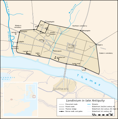
Although the exact reason for the wall's construction is unknown, the wall appears to have been built in the late 2nd or early 3rd century.[1] This was around 80 years after the construction in 120AD of the city's fort, whose north and west walls were thickened and doubled in height to form part of the new city wall. It continued to be developed until at least the end of the 4th century, making it among the last major building projects undertaken by the Romans before the Roman departure from Britain in 410. Reasons for its construction may have been connected to the invasion of northern Britain by Picts who overran Hadrian's Wall in the 180s.[2] It may be linked to the political crisis that emerged in late 2nd century when the governor of Britain Clodius Albinus was consolidating his power after claiming the right of succession as Roman emperor. After a struggle with his rival, Septimius Severus, Albinus was defeated in 197AD at the Battle of Lugdunum (near Lyon, France). The economic stimulus provided by the wall and Septimius's subsequent campaigns in Scotland improved Londinium's financial prosperity in the early 3rd century.
The wall's gateways coincided with their alignment to the British network of Roman roads. The original gates, clockwise from Ludgate in the west to Aldgate, in the east were: Ludgate, Newgate, Cripplegate, Bishopsgate and Aldgate. Aldersgate, between Newgate and Cripplegate, was added around 350AD.[3] (Moorgate, between Cripplegate and Bishopsgate, was built later still, in the medieval period).
The length and size of the wall made it one of the biggest construction projects in Roman Britain. The completed wall, which had gateways, towers and defensive ditches, was built from Kentish ragstone, which was brought by barge from quarries near Maidstone. It was 2 mi (3.2 km) long enclosing an area of about 330 acres (130 ha). It 2.5 m (8 ft 2 in) to 3 m (9.8 ft) wide and up to 6 m (20 ft)) high.[4] The ditch or fossa in front of the outer wall was 2 m (6 ft 7 in) deep and up to 5 m (16 ft) wide. There were at least 22 towers spaced about 64 m (210 ft) apart on the eastern section of the wall.[5]
After Londinium was raided on several occasions by Saxon pirates in the late 3rd century, construction of an additional riverside wall began in 280AD.[3]
Post-Roman use
With the collapse of the Western Roman Empire, Londinium ceased to be the capital of Britannia although Romano-British culture continued in the St Martin-in-the-Fields area until around 450.[6] However, the defences must have retained some of their former formidable strength because the Anglo-Saxon Chronicle mentions that the Romano-British retreated back to London after their bloody defeat at battle of Crecganford (Crayford, Kent) at the hands of Hengist and Horsa, leaders of the Saxon invaders.[7]
From around 500, an Anglo-Saxon settlement known as Lundenwic developed in the same area slightly to the west of the old abandoned Roman city.[8] But by about 680, London had revived sufficiently to become a major Saxon port. However, the upkeep of the wall was not maintained and London fell victim to two successful Viking assaults in 851 and 886 AD.[9]
In 886AD the west-Saxon king, Alfred the Great, formally agreed to the terms of the Danish warlord, Guthrum, concerning the area of political and geographical control that had been acquired by the incursion of the Vikings. Within the eastern and northern part of England with its boundary roughly stretching from London to Chester, the Scandinavians would establish Danelaw. In the same year, the Anglo-Saxon Chronicle recorded that London was "refounded" by Alfred. Archaeological research shows that this involved abandonment of Lundenwic and a revival of life and trade within the old Roman walls. This was part Albert's policy of building an in-depth defence of the Kingdom of Wessex against the Vikings as well as creating an offensive strategy against the Vikings who controlled Mercia. The Burghal Hidage of Southwark was also was created on the southbank of the River Thames during this time.
The city walls of London were repaired as the city slowly grew until about 950 when urban activity increased dramatically.[10] A large Viking army that attacked the London burgh was defeated in 994.[9]
Medieval period
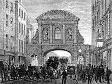
.jpg)
By the 11th century, London was beyond all comparison the largest town in England. Westminster Abbey, rebuilt in the Romanesque style by King Edward the Confessor, was one of the grandest churches in Europe. Winchester had previously been the capital of Anglo-Saxon England, but from this time on, London became the main forum for foreign traders and the base for defence in time of war. In the view of Frank Stenton: "It had the resources, and it was rapidly developing the dignity and the political self-consciousness appropriate to a national capital."[11][12]
The size and importance of London led to the redevelopment of the city's defences. During the early medieval period – following the Norman Conquest of England – the walls underwent substantial work that included crenellations, additional gates and further towers and bastions. Aside from the seven City Wall gates and the four bars, there are the 13 water-gates on the Thames where goods were unloaded from ships. These include Billingsgate and Bridge Gate. Additional there were pedestrian-only gates such as Tower Gate and the postern gate at the Tower of London.[13]
As London continued to grow throughout the medieval period, urban development grew beyond the city walls. This expansion led to the suffix words "Without" and "Within" denote whether an area of the City – and usually applied to the wards – fell outside or within the London Wall, though only Farringdon and (formerly) Bridge have been split into separate wards this way (Bridge Without falling beyond the gates on London Bridge). Some wards – Aldersgate, Bishopsgate and Cripplegate – cover an area that was both within and outside the wall and, although not split into separate wards, often the part (or "division") within the Wall is denoted (on maps, in documents, etc.) as being "within" and the part outside the Wall as being "without". Archaically "Infra" (within) and "Extra" (without) were also used[14] and the terms "intramural" and "extramural"[15] are also used to describe being within or outside the walled part of the city.
The suffix is applied to some churches and parishes near the city gateways such as St Audoen within Newgate or St Botolph-without-Bishopsgate.
Demise
The boundaries of the City of London ceased to coincide with the old city wall as the city expanded its jurisdiction during the medieval period. The city's jurisdiction expanded westwards, crossing the historic western border of the original settlement – the River Fleet – along Fleet Street to Temple Bar. The city also took in the other "city bars," toll gates which were situated just beyond the old walled area: Holborn Bar, Smithfield Bar, and Whitechapel Bar. These were the important entrances to the city and their control was vital in maintaining the city's special privileges over certain trades.
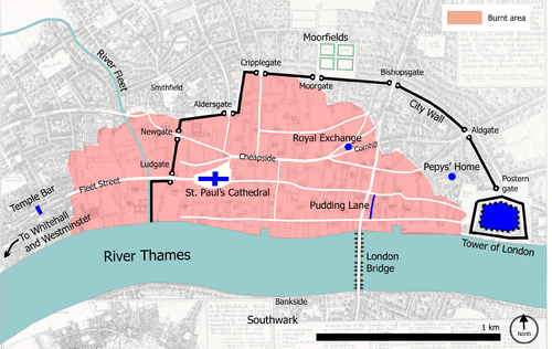
During the Great Fire of London in September 1666, almost all of the medieval City of London inside the wall was destroyed. The seven gates to the City of London, with many repairs and rebuilding over the years, stood until they were all demolished between 1760 and 1767.[16] Work to demolish the walls continued into the 19th centuries, however, large sections of the wall were incorporated into other structures. Some of the tallest ruins in the bomb-damaged City during the Blitz in the Second World War were remnants of London's city wall.
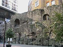
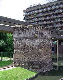
All that remains of the wall are a few (albeit substantial) sections, some of which can be seen in the grounds of the Museum of London, in the Barbican Estate and around Tower Hill. A section near the Museum of London was revealed at Noble Street, after the devastation of an air raid on 29 December 1940 at the height of the Blitz. Another visible section is at St Alphage Gardens, and other sections form part of the walls or foundations of modern buildings and are only visible from inside those buildings. One of the largest and most readily accessed fragments of the wall stands just outside Tower Hill tube station, with a replica statue of the Emperor Trajan standing in front of it.
In 1984 the Museum of London set up a Wall Walk from the Tower of London to the museum, using 23 tiled panels.[17] A number of these have been destroyed in subsequent years.[18] At Noble Street, the panels were replaced by etched glass panels. These were intended as a prototype for new panels along the entire walk, but no further replacements have been made.
Modern course

Part of the route originally taken by the northern wall is commemorated, although now only loosely followed,[19] by the road also named London Wall, on which the Museum of London is located. The modern road starts in the west with the Rotunda junction at Aldersgate, then runs east past Moorgate, from which point it runs parallel to the line of the City Wall, and eventually becomes Wormwood Street before it reaches Bishopsgate. This alignment, however, is the result of rebuilding between 1957 and 1976.[20] Before this, London Wall was narrower, and ran behind the line of the City Wall for its entire length, from Wormwood Street to Wood Street.[21] The western section is now St Alphage Garden.
The wall's moat forms the street of Houndsditch. This was once London's main rubbish disposal site and was notorious for its appalling odour; its name, according to the 16th-century historian John Stow, was derived "from that in old time, when the same lay open, much filth (conveyed forth of the City) especially dead dogges were there laid or cast." The moat was finally covered over and filled in at the end of the 16th century becoming the line of the aforememntioned street.

| Location | Coordinates |
|---|---|
| Museum of London | 51°31′03″N 0°05′49″W / 51.51750°N 0.09694°W |
| Barbican | 51°31′08″N 0°05′35″W / 51.51889°N 0.09306°W |
| London Wall | 51°31′04″N 0°05′43″W / 51.51778°N 0.09528°W |
| St Alphage Garden | 51°31′05″N 0°05′33″W / 51.51806°N 0.09250°W |
| Cooper's Row | 51°30′38″N 0°04′34″W / 51.51056°N 0.07611°W |
| Tower Hill | 51°30′36″N 0°04′33″W / 51.51000°N 0.07583°W |
See also
- Roman London
- Fortifications of London
- List of cities with defensive walls
- List of town walls in England and Wales
- York city walls
- Chester city walls
References
- Citations
- ↑ Ross & Clark 2008, p. 47.
- ↑ Channel4.com Timeline of Romans in Britain
- 1 2 Ross & Clark 2008, p.47.
- ↑ London Wall Museum of London, Retrieved 30 May 2010.
- ↑ Towers on the western section, such as the well-preserved example that can be seen at the Barbican Estate, next to the church of St Giles-without-Cripplegate, were added in the 13th century (Chapman, Hall & Marsh 1986, nos. 15–17).
- ↑ "The last days of Londinium". Museum of London. Archived from the original on 8 January 2009. Retrieved 31 March 2013.
- ↑ "Saxon London in a tale of two cities". British Archeology]]. May 1999. Retrieved 2 September 2016.
- ↑ "The early years of Lundenwic". The Museum of London. Archived from the original on 10 June 2008.
- 1 2 Wheeler, Kip. "Viking Attacks". Retrieved 19 January 2016.
- ↑ Vince, Alan (2001). "London". In Lapidge, Michael; Blair, John; Keynes, Simon; Scragg, Donald. The Blackwell Encyclopedia of Anglo-Saxon England. Blackwell. ISBN 978-0-631-22492-1.
- ↑ Stenton, Frank (1971). Anglo-Saxon England (3rd ed.). Oxford University Press. pp. 538–539. ISBN 978-0-19-280139-5.
- ↑ Blair, John (2001). "Westminster". In Lapidge, Michael; Blair, John; Keynes, Simon; Scragg, Donald. The Blackwell Encyclopedia of Anglo-Saxon England. Blackwell. ISBN 978-0-631-22492-1.
- ↑ "Once Upon a What". Retrieved 6 February 2014.
- ↑ British History Online & HRI Online (examples of infra and extra being used)
- ↑ Mapping London: Making Sense of the City, Simon Foxell, p 17
- ↑ Seven gates to the The City of London
- ↑ London Wall Walk Museum of London, Retrieved 21 May 2010.
- ↑ Shows status of the panels in January 2006 Retrieved 21 May 2010.
- ↑ Smith 1970.
- ↑ Roman House Retrieved 30 May 2010.
- ↑ Z-maps Retrieved 30 May 2010.
- Bibliography
- Chapman, Hugh, Hall, Jenny, and Marsh, Geoffrey (1986), The London Wall Walk London: Museum of London.
- Ross, Cathy, & Clark, John, eds. (2008), London: The Illustrated History. London: Allen Lane.
- Smith, A. (1970), Dictionary of City of London Street Names. London: David & Charles.
External links
| Wikimedia Commons has media related to London Wall and its gates. |
| Wikivoyage has a travel guide for Walk the London Wall. |
- Map of present day street named 'London Wall'
- Museum of London website
- PhotoEssay on London Walls with markers
- London Wall Walk photos geocoded on Flickr
- London Wall Walk Narrated Video Tour
Gates and bars of the City of London | |||
|---|---|---|---|
 | Former gates of London Wall and City bars
Listed clockwise from the West
| ||