Longcot
| Longcot | |
 St Mary's parish church |
|
 Longcot |
|
| Population | 617 (2011 Census) |
|---|---|
| OS grid reference | SU2790 |
| Civil parish | Longcot |
| District | Vale of White Horse |
| Shire county | Oxfordshire |
| Region | South East |
| Country | England |
| Sovereign state | United Kingdom |
| Post town | Faringdon |
| Postcode district | SN7 |
| Dialling code | 01793 |
| Police | Thames Valley |
| Fire | Oxfordshire |
| Ambulance | South Central |
| EU Parliament | South East England |
| UK Parliament | Wantage |
| Website | Longcot Village |
|
|
Coordinates: 51°36′58″N 1°36′18″W / 51.616°N 1.605°W
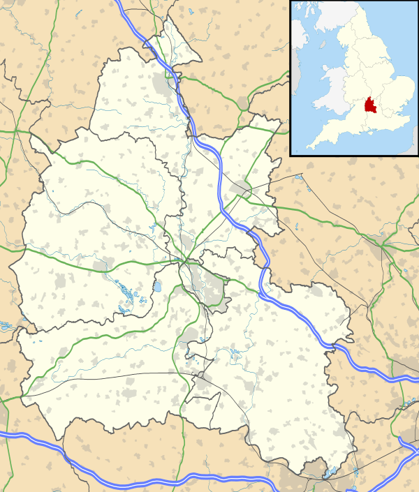
Longcot is a village and civil parish in the Vale of White Horse District. It was part of Berkshire until the 1974 boundary changes transferred it to Oxfordshire. The village is about 3 miles (5 km) south of Faringdon and about 2.5 miles (4 km) northeast of Shrivenham. The A420 road between Swindon and Oxford passes through the parish 1 mile (1.6 km) northwest of the village. The 2011 Census recorded the parish's population as 617.[1]
Geography
Longcot Civil Parish covers 1,894 acres (766 ha). It is in a wide bend of the nascent River Ock, in typical low-lying vale landscape. The view to the south is dominated by the scarp of the Lambourn downs, including the Uffington White Horse.[2]
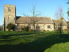
Parish church
The Church of England parish church of Saint Mary the Virgin has a 13th-century Norman nave and chancel.[3] One lancet window on the north side of the chancel is original[3][4] but all other the current windows were inserted later.[4] On the north side of the church they include one two-light Decorated Gothic and one four-light Perpendicular Gothic window.[3] The pulpit is Jacobean.[3][4]
The tower was rebuilt in 1721[4] or 1722.[3] Abraham Rudhall of Gloucester cast five new bells in 1722, followed by the treble bell in 1729[4] to complete a ring of six.
St Mary's is now part of the Church of England Benefice of Shrivenham and Ashbury, which also includes Bourton, Compton Beauchamp, Fernham and Watchfield.[5]
Economic and social history

Longcot (or, until the 20th century, Longcott) was part of Shrivenham Hundred, with the manor and most of the land being held by Viscount Barrington.
For most of its history Longcot was an agricultural community, but population growth in the early 19th century began with the arrival of the Wilts & Berks Canal in 1805[6] and the building of Longcot Wharf, which was the wharf nearest to Faringdon. The village population declined in line with the loss of commercial traffic on the canal to the Great Western Railway, completed in 1841. The canal was formally abandoned by Act of Parliament in 1914.[7]
The parish has had a Church of England school since 1717,[4] the original building in the southwest corner of the churchyard paid for by voluntary subscription.[4] The current school building, built in 1969 opposite The Green on Kings Lane, replaced a previous building on the same site built in 1874.
In 2002 Longcot won two categories in Oxfordshire's Best Kept Village competition: "Best Small Village" and "Best Newcomer".[8]
Amenities
Longcot has a pub, the King and Queen,[9] which is a free house.
Population
The following data has been taken from historical Census information in the public domain.
| Year | Total | Male | Female | Households |
|---|---|---|---|---|
| 1871 | 494 | 229 | 265 | 110 |
| 1881 | 393 | 198 | 195 | 92 |
| 1891 | 310 | 162 | 148 | 77 |
| 1901 | 256 | 139 | 117 | 65 |
| 1911 | 334 | 169 | 165 | 77 |
| 1921 | 295 | 146 | 149 | 71 |
| 1931 | 264 | 139 | 125 | 76 |
| 1941 | No Census Taken | |||
| 1951 | 285 | 143 | 142 | 88 |
| 1961 | 337 | 173 | 164 | 102 |
| 1971 | 446 | |||
| 1981 | ||||
| 1991 | ||||
| 2001 | 574 | 290 | 284 | 220 |
References
- ↑ "Area: Longcot (Parish): Key Figures for 2011 Census: Key Statistics". Neighbourhood Statistics. Office for National Statistics. Retrieved 25 May 2015.
- ↑ Panoramio photograph of the Uffington White Horse
- 1 2 3 4 5 Pevsner 1966, p. 170.
- 1 2 3 4 5 6 7 Page & Ditchfield 1924, pp. 531–543.
- ↑ Archbishops' Council (2015). "Benefice of Shrivenham and Ashbury". A Church Near You. Church of England. Retrieved 25 May 2015.
- ↑ Dalby 2000, p. 23.
- ↑ Dalby 2000, p. 96.
- ↑ "Villagers' pride pays off in battle for honours". The Oxford Times. Newsquest. 25 July 2002.
- ↑ The King & Queen
Sources and further reading
- Dalby, L.J. (2000) [1971]. The Wilts & Berks Canal (3rd ed.). Usk: Oakwood Press. p. 23. ISBN 0-85361-562-4.
- Page, W.H.; Ditchfield, P.H., eds. (1924). A History of the County of Berkshire. Victoria County History. 4. assisted by John Hautenville Cope. London: The St Katherine Press. pp. 466–471.
- Pevsner, Nikolaus (1966). Berkshire. The Buildings of England. Harmondsworth: Penguin Books. pp. 171–172.
- Richards, Guy; Dalton-Morris, Shirley. Longcot: A Village in the Vale. ISBN 0-9536602-0-6.
External links
| Wikimedia Commons has media related to Longcot. |
- Longcot Village
- Great Britain Historical GIS / University of Portsmouth, Longcott Berkshire. Retrieved on 2008-01-01.
- Longcot & Fernham C of E Primary School
