Woolstone, Oxfordshire
| Woolstone | |
 Woolstone |
|
| Population | 140 (2001 census)[1] |
|---|---|
| OS grid reference | SU2987 |
| Civil parish | Woolstone |
| District | Vale of White Horse |
| Shire county | Oxfordshire |
| Region | South East |
| Country | England |
| Sovereign state | United Kingdom |
| Post town | Faringdon |
| Postcode district | SN7 |
| Dialling code | 01367 |
| Police | Thames Valley |
| Fire | Oxfordshire |
| Ambulance | South Central |
| EU Parliament | South East England |
| UK Parliament | Wantage |
| Website | Woolstone Village |
|
|
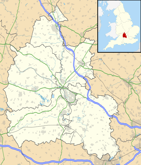
Coordinates: 51°35′13″N 1°34′37″W / 51.587°N 1.577°W
Woolstone is a village and civil parish about 4.5 miles (7 km) south of Faringdon in the Vale of White Horse. Woolstone was part of Berkshire until the 1974 boundary changes transferred it to Oxfordshire.
The village is a spring line settlement at the foot of the Berkshire Downs. Woolstone Wells are a group of springs in the chalk escarpment less than 1⁄2 mile (800 m) south of the village. A stream flows north from the springs past the village of Uffington and joins the River Ock about 2 miles (3 km) north of Woolstone village.
Woolstone parish is long and thin, embracing both low-lying land in the vale and upland pasture on the downs. The parish extends just over 4 miles (6.4 km) north – south but is slightly less than 1 mile (1.6 km) wide at its widest point.
Archaeology
The Ridgeway runs east-west through the parish along the top of the chalk escarpment just over 1 mile (1.6 km) south of the village.[2] On Woolstone Down about 2 miles (3 km) south of the village are a disc barrow about 50 feet (15 m) in diameter and two bowl barrows.[3] About 1⁄2 mile (800 m) south of the barrows is an ancient field system. Iron Age pottery has been found just west of Woolstone village.[4]
Steam ploughing in 1884 revealed remains of a Roman villa built of clunch[5] in a field just west of Woolstone village.[6] Members of the Oxfordshire Architectural and Historical Society visited the site in 1884, found the south wall of the villa was at least 110 feet (34 m) long and there were Roman mosaics in two central rooms of the villa.[7] The villa was excavated again in 1955.[4] No permanent marker of the site was left after either excavation, but a geophysical survey tentatively identified what may be the site in 2007.[8]
The 1884 excavation found three human skeletons in the corridor of the Roman villa.[9] The OAHS archaeologists took these to be Saxon burials.[9]
Toponym
In the 11th century the village's toponym was Olvrichestone. In the 13th century its forms included Wulwricheston, Wluricheston and Wulevycheston. It evolved into Wlfricheston and Woulricheston in the 14th century and Wolierston and Wolston in the 16th century before reaching its present form.[2]
Manor
The Domesday Book of 1086 records that the Bishop of Winchester held an estate at Woolstone assessed at ten hides. Its income was used to support the Benedictine St. Swithun's Priory at Winchester. The manor of Woolstone was a property of the Priory by the 13th century and in 1308–09 it had a capital messuage that included a lord's chamber, kitchen, stable, garden and dovecot.[2]
The Priory surrendered its all property to the Crown in the Dissolution of the Monasteries in 1539. The Crown granted Woolstone to Sir Thomas Seymour, who after the death of Henry VIII was created 1st Baron Seymour of Sudeley. However, in 1549 Seymour was executed for treason and attainted so all his properties reverted to the Crown.[2]
In 1551 the Crown granted Woolstone to the courtier Thomas Weldon, who in 1566 or 1567 left it to his son William. In about 1583 the manor passed from William Weldon to Edmund Wiseman, and it descended in the Wiseman family for several generations until some time after 1694. By 1712 the Wisemans had sold Woolstone to Bartholomew Tipping IV, a former High Sheriff of Berkshire. In 1798 Bartholomew Tipping VII, also a former High Sheriff of Berkshire, died childless and left the manor to his niece Mary Anne Wroughton and her husband Rev. Philip Wroughton.[2]
In 1814 the Wroughtons sold Woolstone to Viscount Uffington, who in 1825 succeeded as 2nd Earl of Craven. In 1921 William Craven, 5th Earl of Craven inherited the manor.[2]
South-east of All Saints' parish church are Manor Farm and a Georgian house of six bays with a hipped roof.[3]
Parish church
The Church of England parish church of All Saints was built in about 1195 as a dependent chapel of Uffington. The building is of chalk and clunch, with stone quoins.[2] The north doorway is original late Norman,[3] as are two lancet windows, one each on the north and south sides of the nave[3] towards the west end.[2]
The chancel arch looks early 13th century.[3] There is a south transept, whose arch and south window look late 13th century. Two north windows of the chancel are Decorated Gothic and one north window in the nave also appears to be early 14th century.[3] The font is 14th century or later and is unusual in being a lead bowl mounted on a stone pillar.[2]
In the 18th century the east wall of the chancel was rebuilt in brick with a single-light east window, and the west window of the nave was altered. In 1914 the east window was replaced with a new one of two lights.[2]
In 1783 the church had one bell. In the 19th or early in the 20th century the bellcote was replaced with the present one on the west gable of the nave.[2]
Woolstone was made an ecclesiastical parish separate from Uffington in 1846. All Saints' is now once again part of the Uffington Benefice, along with the parishes of Baulking and Shellingford.[10]
Economic and social history
A watermill at Woolstone is recorded in 1325. It was demolished in about 1850 and replaced with a house, Woolstone Lodge.[2]
The common lands of Uffington, Baulking and Woolstone were enclosed in 1776.[2]
In 1805–07 the Wilts & Berks Canal was extended eastwards from Longcot to Challow,[11] passing through Woolstone parish about 1⁄2 mile (800 m) north of the village. The canal had a wharf at Uffington 1 mile (1.6 km) north of Woolstone. The Great Western Main Line was built through the northernmost part of the parish and opened in 1840. The canal declined until 1901, when the Stanley Aqueduct over the River Marden in Wiltshire collapsed and the little remaining traffic virtually ceased. The route was formally abandoned in 1914. The Wilts & Berks Canal Trust is currently restoring the canal.
Amenities
Woolstone has a timber-framed public house, the White Horse,[12] controlled by Arkell's Brewery.[13]
References
- ↑ "Area selected: Vale of White Horse (Non-Metropolitan District)". Neighbourhood Statistics: Full Dataset View. Office for National Statistics. Retrieved 6 February 2011.
- 1 2 3 4 5 6 7 8 9 10 11 12 13 Page & Ditchfield, 1924, pages 543–551
- 1 2 3 4 5 6 Pevsner, 1966, page 313
- 1 2 Wintle, 2007, page 2
- ↑ Wintle, 2007, page 15
- ↑ Wintle, 2007, pages 1 & 4
- ↑ Wintle, 2007, pages 1 & 10
- ↑ Wintle, 2007, pages 11–14
- 1 2 Wintle, 2007, page 1
- ↑ Uffington Benefice
- ↑ Dalby, 2000, page 23
- ↑ White Horse at Woolstone
- ↑ Arkell's Pubs: The White Horse at Woolstone
Sources
- Dalby, L.J. (2000) [1971]. The Wilts and Berks Canal (3rd ed.). Usk: Oakwood Press. p. 23. ISBN 0-85361-562-4.
- Page, W.H.; Ditchfield, P.H., eds. (1924). A History of the County of Berkshire, Volume 4. Victoria County History. pp. 543–551.
- Pevsner, Nikolaus (1966). Berkshire. The Buildings of England. Harmondsworth: Penguin Books. p. 313.
- Wintle, William (April 2007). Geophysical Survey of a Roman Villa at Woolstone, Oxfordshire April 2007 (PDF). Oxford: William Wintle. Retrieved 9 February 2011.
External links
![]() Media related to Woolstone, Oxfordshire at Wikimedia Commons
Media related to Woolstone, Oxfordshire at Wikimedia Commons
