180th meridian
For ante meridiem (AM), the time before midday, see
12-hour clock.

Antimeridian
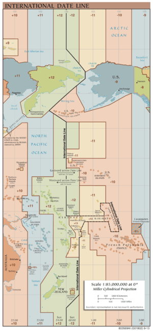
The International Date Line zigzags around the 180th Meridian.
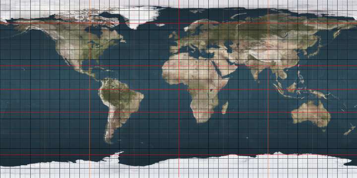
The 180th meridian or antimeridian[1] is the meridian which is 180° east or west of the Prime Meridian with which it forms a great circle which divides the earth into the Western Hemisphere and Eastern Hemisphere. It is common to both east longitude and west longitude. It is used as the basis for the International Date Line because it for the most part passes through the open waters of the Pacific Ocean. However, the meridian passes through Russia and Fiji as well as Antarctica.
Starting at the North Pole and heading south to the South Pole, the 180th meridian passes through:
Co-ordinates
(approximate) |
Country, territory or sea |
Notes |
|---|
| 90°0′N 180°0′E / 90.000°N 180.000°E / 90.000; 180.000 (Arctic Ocean) |
Arctic Ocean |
|
| 71°32′N 180°0′E / 71.533°N 180.000°E / 71.533; 180.000 (Russia) |
 Russia Russia |
Chukotka Autonomous Okrug — Wrangel Island |
| 70°58′N 180°0′E / 70.967°N 180.000°E / 70.967; 180.000 (Chukchi Sea) |
Chukchi Sea |
|
| 68°59′N 180°0′E / 68.983°N 180.000°E / 68.983; 180.000 (Russia) |
Russia |
Chukotka Autonomous Okrug |
| 65°02′N 180°0′E / 65.033°N 180.000°E / 65.033; 180.000 (Bering Sea) |
Bering Sea |
|
| 52°0′N 180°0′E / 52.000°N 180.000°E / 52.000; 180.000 (Amchitka Pass) |
Amchitka Pass |
Passing just east of Semisopochnoi Island, Alaska,  United States (at 51°57′N 179°47′E / 51.950°N 179.783°E / 51.950; 179.783 (Semisopochnoi Island)) United States (at 51°57′N 179°47′E / 51.950°N 179.783°E / 51.950; 179.783 (Semisopochnoi Island)) |
| 51°0′N 180°0′E / 51.000°N 180.000°E / 51.000; 180.000 (Pacific Ocean) |
Pacific Ocean |
Passing just east of Nukulaelae atoll,  Tuvalu (at 9°25′S 179°52′E / 9.417°S 179.867°E / -9.417; 179.867 (Nukulaelae atoll)) Tuvalu (at 9°25′S 179°52′E / 9.417°S 179.867°E / -9.417; 179.867 (Nukulaelae atoll))
Passing just west of the island of Cikobia,  Fiji (at 15°43′S 179°59′W / 15.717°S 179.983°W / -15.717; -179.983 (Cikobia)) Fiji (at 15°43′S 179°59′W / 15.717°S 179.983°W / -15.717; -179.983 (Cikobia)) |
| 16°9′S 180°0′E / 16.150°S 180.000°E / -16.150; 180.000 (Fiji) |
Fiji |
Islands of Vanua Levu, Rabi, and Taveuni |
| 16°59′S 180°0′E / 16.983°S 180.000°E / -16.983; 180.000 (Pacific Ocean) |
Pacific Ocean |
Passing just east of the island of Moala, Fiji (at 18°33′S 179°57′E / 18.550°S 179.950°E / -18.550; 179.950 (Moala))
Passing just west of the island of Totoya, Fiji (at 19°0′S 179°52′W / 19.000°S 179.867°W / -19.000; -179.867 (Totoya))
Passing just east of the island of Matuku, Fiji (at 19°10′S 179°47′E / 19.167°S 179.783°E / -19.167; 179.783 (Matuku)) |
| 60°0′S 180°0′E / 60.000°S 180.000°E / -60.000; 180.000 (Southern Ocean) |
Southern Ocean |
|
| 78°13′S 180°0′E / 78.217°S 180.000°E / -78.217; 180.000 (Antarctica) |
Antarctica |
Ross Dependency, claimed by  New Zealand New Zealand |
|
The meridian also passes between (but not particularly close to):
The only place where roads cross this meridian, and where there are buildings very close to it, is in Fiji.
Software representation problems
Many geographic software libraries or data formats project the world to a rectangle; very often this rectangle is split exactly at the 180th meridian. This often makes it non-trivial to do simple tasks (like representing an area, or a line) over the 180th meridian. Some examples:
- The GeoJSON specification strongly suggests splitting geometries so that neither of their parts cross the antimeridian.[2]
- In OpenStreetMap, areas (like the boundary of Russia) are split at the 180th meridian.
See also
Notes

 Kiribati;