Lonsdale, Minnesota
| City of Lonsdale, Minnesota | |
|---|---|
| City | |
|
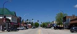
Downtown Lonsdale | |
| Motto: Preserving Our Heritage To Better Our Future | |
 Location in the state of Minnesota, USA | |
| Coordinates: 44°28′48″N 93°25′50″W / 44.48000°N 93.43056°WCoordinates: 44°28′48″N 93°25′50″W / 44.48000°N 93.43056°W | |
| Country | United States |
| State | Minnesota |
| County | Rice |
| Incorporated | 1903 |
| Government | |
| • Mayor | Tim Rud |
| Area[1] | |
| • Total | 2.77 sq mi (7.17 km2) |
| • Land | 2.73 sq mi (7.07 km2) |
| • Water | 0.04 sq mi (0.10 km2) |
| Elevation | 1,093 ft (333 m) |
| Population (2010)[2] | |
| • Total | 3,674 |
| • Estimate (2012[3]) | 3,757 |
| • Density | 1,345.8/sq mi (519.6/km2) |
| Time zone | CST (UTC-4) |
| • Summer (DST) | CST (UTC-5) |
| ZIP code | 55046 |
| Area code(s) | 507 |
| FIPS code | 27-38150[4] |
| GNIS feature ID | 0647154[5] |
| Website | www.lonsdale.govoffice.com |
Lonsdale is a city in Rice County, Minnesota, United States. The population was 3,674 at the 2010 census.[6]
History
Lonsdale was laid out in 1903.[7]
Geography
According to the United States Census Bureau, the city has a total area of 2.77 square miles (7.17 km2); 2.73 square miles (7.07 km2) is land and 0.04 square miles (0.10 km2) is water.[1]
Minnesota State Highway 19 serves as a main route in the city.
Lonsdale is six miles (10 km) from Interstate 35.
Demographics
| Historical population | |||
|---|---|---|---|
| Census | Pop. | %± | |
| 1910 | 271 | — | |
| 1920 | 459 | 69.4% | |
| 1930 | 508 | 10.7% | |
| 1940 | 545 | 7.3% | |
| 1950 | 510 | −6.4% | |
| 1960 | 541 | 6.1% | |
| 1970 | 622 | 15.0% | |
| 1980 | 1,160 | 86.5% | |
| 1990 | 1,252 | 7.9% | |
| 2000 | 1,491 | 19.1% | |
| 2010 | 3,674 | 146.4% | |
| Est. 2015 | 3,843 | [8] | 4.6% |
| U.S. Decennial Census | |||
2010 census
As of the census[2] of 2010, there were 3,674 people, 1,277 households, and 976 families residing in the city. The population density was 1,345.8 inhabitants per square mile (519.6/km2). There were 1,370 housing units at an average density of 501.8 per square mile (193.7/km2). The racial makeup of the city was 96.5% White, 0.4% African American, 0.3% Native American, 0.8% Asian, 0.3% Pacific Islander, 0.3% from other races, and 1.4% from two or more races. Hispanic or Latino of any race were 1.7% of the population.
There were 1,277 households of which 49.4% had children under the age of 18 living with them, 64.4% were married couples living together, 6.7% had a female householder with no husband present, 5.3% had a male householder with no wife present, and 23.6% were non-families. 16.6% of all households were made up of individuals and 4.6% had someone living alone who was 65 years of age or older. The average household size was 2.87 and the average family size was 3.27.
The median age in the city was 29.5 years. 34.2% of residents were under the age of 18; 5.8% were between the ages of 18 and 24; 39.2% were from 25 to 44; 15.9% were from 45 to 64; and 4.9% were 65 years of age or older. The gender makeup of the city was 51.1% male and 48.9% female.
2000 census
As of the census[4] of 2000, there were 1,491 people, 560 households, and 394 families residing in the city. The population density was 1,127.3 people per square mile (436.1/km²). There were 577 housing units at an average density of 436.2 per square mile (168.8/km²). The racial makeup of the city was 98.66% White, 0.20% African American, 0.40% Native American, 0.13% Asian, and 0.60% from two or more races. Hispanic or Latino of any race were 0.34% of the population.
There were 560 households out of which 39.3% had children under the age of 18 living with them, 58.9% were married couples living together, 6.8% had a female householder with no husband present, and 29.5% were non-families. 23.9% of all households were made up of individuals and 9.6% had someone living alone who was 65 years of age or older. The average household size was 2.62 and the average family size was 3.12.
In the city the population was spread out with 28.4% under the age of 18, 9.5% from 18 to 24, 33.3% from 25 to 44, 16.6% from 45 to 64, and 12.3% who were 65 years of age or older. The median age was 32 years. For every 100 females there were 99.6 males. For every 100 females age 18 and over, there were 95.6 males.
The median income for a household in the city was $50,054, and the median income for a family was $58,676. Males had a median income of $37,800 versus $25,607 for females. The per capita income for the city was $20,368. About 4.6% of families and 6.1% of the population were below the poverty line, including 4.1% of those under age 18 and 18.8% of those age 65 or over.
Education
Residents of the Lonsdale area are served by two public school districts and one Catholic school. They include:
Tri-City United Public Schools - ISD # 2905
- Tri-City United High School - Montgomery
- Montgomery Elementary and Middle School
- Le Center Elementary and Middle School
- Lonsdale Elementary
New Prague Public Schools - ISD # 721
- New Prague High School
- New Prague Middle School
- Falcon Ridge Elementary School
References
- 1 2 "US Gazetteer files 2010". United States Census Bureau. Retrieved 2012-11-13.
- 1 2 "American FactFinder". United States Census Bureau. Retrieved 2012-11-13.
- ↑ "Population Estimates". United States Census Bureau. Retrieved 2013-05-28.
- 1 2 "American FactFinder". United States Census Bureau. Retrieved 2008-01-31.
- ↑ "US Board on Geographic Names". United States Geological Survey. 2007-10-25. Retrieved 2008-01-31.
- ↑ "2010 Census Redistricting Data (Public Law 94-171) Summary File". American FactFinder. United States Census Bureau. Retrieved 27 April 2011.
- ↑ Upham, Warren (1920). Minnesota Geographic Names: Their Origin and Historic Significance. Minnesota Historical Society. p. 462.
- ↑ "Annual Estimates of the Resident Population for Incorporated Places: April 1, 2010 to July 1, 2015". Retrieved July 2, 2016.
External links
Municipalities and communities of Rice County, Minnesota, United States | ||
|---|---|---|
| Cities | 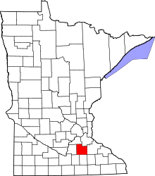 | |
| Townships | ||
| CDP | ||
| Unincorporated communities | ||
| Footnotes | ‡This populated place also has portions in an adjacent county or counties | |