Lowell, Wisconsin
| Lowell, Wisconsin | |
|---|---|
| Village | |
| Coordinates: 43°19′45″N 88°49′44″W / 43.32917°N 88.82889°WCoordinates: 43°19′45″N 88°49′44″W / 43.32917°N 88.82889°W | |
| Country | United States |
| State | Wisconsin |
| County | Dodge |
| Area[1] | |
| • Total | 1.05 sq mi (2.72 km2) |
| • Land | 1.00 sq mi (2.59 km2) |
| • Water | 0.05 sq mi (0.13 km2) |
| Elevation[2] | 830 ft (253 m) |
| Population (2010)[3] | |
| • Total | 340 |
| • Estimate (2012[4]) | 334 |
| • Density | 340.0/sq mi (131.3/km2) |
| Time zone | Central (CST) (UTC-6) |
| • Summer (DST) | CDT (UTC-5) |
| FIPS code | 55-45975[5] |
| GNIS feature ID | 1583601[2] |
| Website | http://www.villageoflowell.com |
Lowell is a village in Dodge County, Wisconsin, United States, along the Beaver Dam River. The population was 340 at the 2010 census. The village is located within the Town of Lowell.
Geography
Lowell is located at 43°20′20″N 88°49′13″W / 43.33889°N 88.82028°W (43.338909, -88.82055).[6]
According to the United States Census Bureau, the village has a total area of 1.05 square miles (2.72 km2), of which, 1.00 square mile (2.59 km2) of it is land and 0.05 square miles (0.13 km2) is water.[1]
Demographics
| Historical population | |||
|---|---|---|---|
| Census | Pop. | %± | |
| 1880 | 400 | — | |
| 1890 | 304 | −24.0% | |
| 1900 | 333 | 9.5% | |
| 1910 | 318 | −4.5% | |
| 1920 | 293 | −7.9% | |
| 1930 | 288 | −1.7% | |
| 1940 | 282 | −2.1% | |
| 1950 | 319 | 13.1% | |
| 1960 | 341 | 6.9% | |
| 1970 | 322 | −5.6% | |
| 1980 | 326 | 1.2% | |
| 1990 | 300 | −8.0% | |
| 2000 | 366 | 22.0% | |
| 2010 | 340 | −7.1% | |
| Est. 2015 | 325 | [7] | −4.4% |
2010 census
As of the census[3] of 2010, there were 340 people, 136 households, and 89 families residing in the village. The population density was 340.0 inhabitants per square mile (131.3/km2). There were 163 housing units at an average density of 163.0 per square mile (62.9/km2). The racial makeup of the village was 99.4% White, 0.3% African American, and 0.3% Native American. Hispanic or Latino of any race were 1.5% of the population.
There were 136 households of which 31.6% had children under the age of 18 living with them, 50.0% were married couples living together, 10.3% had a female householder with no husband present, 5.1% had a male householder with no wife present, and 34.6% were non-families. 27.9% of all households were made up of individuals and 11% had someone living alone who was 65 years of age or older. The average household size was 2.50 and the average family size was 3.06.
The median age in the village was 42.3 years. 21.5% of residents were under the age of 18; 6.5% were between the ages of 18 and 24; 28.3% were from 25 to 44; 31% were from 45 to 64; and 12.9% were 65 years of age or older. The gender makeup of the village was 50.6% male and 49.4% female.
2000 census
As of the census[5] of 2000, there were 366 people, 142 households, and 93 families residing in the village. The population density was 368.1 people per square mile (142.7/km²). There were 153 housing units at an average density of 153.9 per square mile (59.7/km²). The racial makeup of the village was 96.17% White, 0.27% Black or African American, 1.09% Asian, 1.64% from other races, and 0.82% from two or more races. 3.28% of the population were Hispanic or Latino of any race.
There were 142 households out of which 37.3% had children under the age of 18 living with them, 51.4% were married couples living together, 8.5% had a female householder with no husband present, and 34.5% were non-families. 27.5% of all households were made up of individuals and 14.1% had someone living alone who was 65 years of age or older. The average household size was 2.58 and the average family size was 3.18.
In the village the population was spread out with 30.3% under the age of 18, 5.7% from 18 to 24, 32.2% from 25 to 44, 21.6% from 45 to 64, and 10.1% who were 65 years of age or older. The median age was 34 years. For every 100 females there were 104.5 males. For every 100 females age 18 and over, there were 104.0 males.
The median income for a household in the village was $43,594, and the median income for a family was $46,750. Males had a median income of $35,694 versus $23,333 for females. The per capita income for the village was $14,393. About 4.8% of families and 9.5% of the population were below the poverty line, including 14.7% of those under age 18 and 6.3% of those age 65 or over.
Notable natives and residents
- Milton H. Erickson, psychiatrist
- Charles A. Kading, Wisconsin politician
- John Lowth, Wisconsin politician
Images
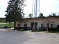 Post office and public library
References
- 1 2 "US Gazetteer files 2010". United States Census Bureau. Retrieved 2012-11-18.
- 1 2 "US Board on Geographic Names". United States Geological Survey. 2007-10-25. Retrieved 2008-01-31.
- 1 2 "American FactFinder". United States Census Bureau. Retrieved 2012-11-18.
- ↑ "Population Estimates". United States Census Bureau. Retrieved 2013-06-24.
- 1 2 "American FactFinder". United States Census Bureau. Retrieved 2008-01-31.
- ↑ "US Gazetteer files: 2010, 2000, and 1990". United States Census Bureau. 2011-02-12. Retrieved 2011-04-23.
- ↑ "Annual Estimates of the Resident Population for Incorporated Places: April 1, 2010 to July 1, 2015". Retrieved July 2, 2016.
- ↑ "Census of Population and Housing". Census.gov. Retrieved June 4, 2015.
Municipalities and communities of Dodge County, Wisconsin, United States | ||
|---|---|---|
| Cities | 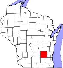 | |
| Villages | ||
| Towns | ||
| CDPs | ||
| Unincorporated communities |
| |
| Ghost towns | ||
| Footnotes | ‡This populated place also has portions in an adjacent county or counties | |