Lubań
| Lubań | |||
|---|---|---|---|
|
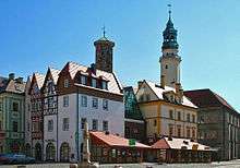
Old town | |||
| |||
 Lubań | |||
| Coordinates: 51°07′N 15°18′E / 51.117°N 15.300°E | |||
| Country |
| ||
| Voivodeship | Lower Silesian | ||
| County | Lubań County | ||
| Gmina | Lubań (urban gmina) | ||
| Government | |||
| • Mayor | Arkadiusz Słowiński | ||
| Area | |||
| • Total | 16.12 km2 (6.22 sq mi) | ||
| Population (2006) | |||
| • Total | 22,137 | ||
| • Density | 1,400/km2 (3,600/sq mi) | ||
| Time zone | CET (UTC+1) | ||
| • Summer (DST) | CEST (UTC+2) | ||
| Postal code | 59-800 | ||
| Car plates | DLB | ||
| Website | http://www.luban.pl | ||
.jpg)

Lubań [ˈlubaɲ] (German: Lauban) is a town in the Lower Silesian Voivodeship in southwest Poland. It is the administrative seat of Lubań County and also of the smaller Gmina Lubań (although it is not part of the territory of the latter, as the town is a separate urban gmina in its own right).
Geography
Situated north of the Jizera Mountains on the western shore of the Kwisa River, Lubań is part of the historic Upper Lusatia region. It is located about 25 km (16 mi) east of Zgorzelec/Görlitz and about 45 km (28 mi) northwest of Jelenia Góra. From 1975–1998 it was part of the former Jelenia Góra Voivodeship.
Lubań is a stop on the Polish sections of the Way of St. James pilgrimage route.
History
Lubań probably is at the site of a small settlement established by the West Slavic Milceni tribe in the 9th and 10th century, whose lands up to the Kwisa River from 927 on were gradually conquered by the German king Henry the Fowler and incorporated into the marca Geronis in 939. In 965 ill-defined the Milceni territory became part of the Imperial Margraviate of Meissen. In 1156 Emperor Frederick Barbarossa vested his ally, the Přemyslid duke Vladislaus II of Bohemia with the territory around Bautzen (Budissin) that later would be called "Upper Lusatia".
Likewise several other city foundings under the rule of the Přemyslid dynasty, Lauban, owing to its favourable location on the historic Via Regia trade route close to the border with the Duchy of Silesia, expanded rapidly in the course of the German Ostsiedlung. In 1220 or 1268 (the second date is more probable) it is documented as a town with Magdeburg rights. Since about 1253 Upper Lusatia temporarily had been under the rule of the Ascanian margraves John I and Otto III of Brandenburg. In 1319 the Silesian Duke Henry I of Jawor occupied the Upper Lusatian lands up to the town of Görlitz including Lauban. He built a new town hall, whose ruins can be seen today (Kramarska Tower). Henry ruled the town for eighteen years, before he finally ceded it to his brother-in-law King John of Bohemia.
The centre of the medieval town was a square marketplace (rynek) with perpendicular streets, leading to four gates: Zgorzelecka to the west, Bracka (built in 1318 together with stone curtains by Duke Henry of Jawor) to the south, Mikołajska to the east and Nowogrodziecka to the north. The first mayor of the town was Nikolaus Hermann, and Lauban received its own seal.
Under the rule of the Bohemian Crown, Lubań on 10 August 1346 established the Lusatian League, together with the towns of Görlitz (Zgorzelec), Löbau (Lubii), Zittau (Żytawa), Bautzen (Budziszyn) and Kamenz (Kamieniec Łużycki). Twice however, in 1427 and 1431, the Hussites completely demolished the town, it was quickly rebuilt. In its history, the town has repeatedly suffered great fires, which often ruined the whole town. Many inhabitants died as a result of plagues. According to the rules of the 1635 Peace of Prague, the Habsburg Emperor Ferdinand II in his capacity as Bohemian king passed the Lusatias with the town of Lauban to the Electorate of Saxony. From 1697 to 1706 and from 1709 to 1763 Lubań was under the rule of Polish kings and Saxon electors Augustus II the Strong and Augustus III of Poland. During the Augustus' II rule, the Dom pod Okrętem ("House under the Ship") was built.
Following the Napoleonic wars, in 1815 the Lusatian territory around Lubań and Görlitz was annexed by the Kingdom of Prussia after the Vienna Congress and incorporated into the Province of Silesia. In 1865 and 1866 Lubań obtained railway connections with Görlitz and Hirschberg.
Lubań was the site of one of the last Nazi German victories in World War II. After it was taken by the Red Army on 16 February 1945, the Wehrmacht successfully retook the town in a counterattack on 8 March 1945.[1][2][3]
At the end of World War II in 1945, the region east of the Oder-Neisse line became part of the Poland following its capture by the Red Army and the decisions of the Potsdam Conference. The German inhabitants who had not already fled ahead of the Soviet army were then expelled westward and replaced with Polish settlers.
In 1992–2004 the marketplace was renovated. Streets were paved and town houses around the Kramarska Tower were rebuilt.
Places of interest
Points of interest in Lubań include:
- Kramarska Tower – remains of the 13th-century Gothic town hall
- Stone curtains (1318) made from basalt from a local quarry. Behind the curtains were situated four main gates: Nowogrodziecka, Mikołajska, Bracka i Zgorzelecka
- Bracka Donjon (built in 1318 by Henryk Jaworski)
- Trynitarska Tower (1320 r.) on Wrocławska street, a remnant of Holy Trinity Church
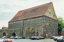
- Salt House or Cereal House (Polish: Dom Solny/Dom Zbożowy) (1539), a building made of basalt
- Town hall built in 1554 in Renaissance style
- House under the Ship (Polish: Dom pod Okrętem) (1715), the house of the Kirchoff family
- Park on Kamienna Góra hill (14 hectares). Contains evidence of an extinct tertiary volcano, such as basalt columns or “volcanic bombs”; also has a wood with exotic trees: Liriodendron tulipifera, Pinus pinea, Pinus nigra. Kamienna Góra also has an amphitheatre and a castle-style residence, which was built in 1824 and rebuilt in 1909, offering views of the Sudetes mountains (including Śnieżka, the highest peak).
Notable residents
.jpg)
- Martin Behm, Lutheran pastor, writer
- Johann Knöfel, composer
- Jakob Bartsch, astronomer
- Konrad Gottlob Anton, orientalist
- Friedrich Wilhelm Alexander von Mechow, explorer of Africa
- Elisabeth von Saldern, Mother Superior
- Karl Hanke, NSDAP-Politician
- Otto Kuss, theologian
- Albert Brux, Wehrmacht officer
- Heinz Kessler, general, politician
- Horst Klaus, unionist
- Konrad Weiß, film director
- Helmut Bakaitis, actor
- Jacek Dewódzki, musician
- Agnieszka Stanuch, slalom canoer
- Angelika Jakubowska, model
- Zuzanna Efimienko, volleyball player
International relations
Twin towns - Sister cities
In 1992 the Lusatian Six-City League was reactivated. Lubań is further twinned with:
References
- ↑ Bitwa o Lubań 17.02 - 06.03. 1945r.
- ↑ Book: "Lubań 1945. The last victory of the Third Reich" ("Lubań 1945. Ostatnie Zwycięstwo III Rzeszy") Arkadiusz Wilczyński
- ↑ Battle for Lubań 64th Anniversary
External links
| Wikimedia Commons has media related to Lubań, Lower Silesian Voivodeship. |
- Official town website
- Jewish Community in Lubań on Virtual Shtetl
 Texts on Wikisource:
- "Lauban". Encyclopædia Britannica (11th ed.). 1911.
- "Lauban". Encyclopedia Americana. 1920.
| Urban gminas |
|  |
|---|---|---|
| Urban-rural gminas | ||
| Rural gminas | ||
| Villages | ||
|---|---|---|
| Seat (not part of the gmina) | ||
Coordinates: 51°07′N 15°18′E / 51.117°N 15.300°E