Madison Township, Sandusky County, Ohio
| Madison Township, Sandusky County, Ohio | |
|---|---|
| Township | |
|
Fields east of Rollersville | |
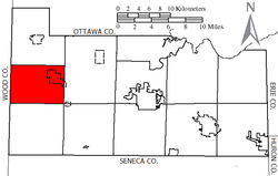 Location of Madison Township, Sandusky County, Ohio. | |
| Coordinates: 41°23′3″N 83°20′15″W / 41.38417°N 83.33750°WCoordinates: 41°23′3″N 83°20′15″W / 41.38417°N 83.33750°W | |
| Country | United States |
| State | Ohio |
| County | Sandusky |
| Area | |
| • Total | 27.3 sq mi (70.6 km2) |
| • Land | 27.2 sq mi (70.5 km2) |
| • Water | 0.1 sq mi (0.2 km2) |
| Elevation[1] | 679 ft (207 m) |
| Population (2000) | |
| • Total | 3,721 |
| • Density | 136.7/sq mi (52.8/km2) |
| Time zone | Eastern (EST) (UTC-5) |
| • Summer (DST) | EDT (UTC-4) |
| FIPS code | 39-46592[2] |
| GNIS feature ID | 1086913[1] |

Madison Township is one of the twelve townships of Sandusky County, Ohio, United States. As of the 2000 census, 3,721 people lived in the township, 1,215 of whom lived in the unincorporated portions of the township.[3]
Geography
Located in the western part of the county, it borders the following townships:
- Woodville Township - north
- Washington Township - east
- Jackson Township - southeast corner
- Scott Township - south
- Montgomery Township, Wood County - southwest corner
- Freedom Township, Wood County - west
Most of the village of Gibsonburg is located in eastern Madison Township, with the unincorporated community of Rollersville straddling the southern border with Scott Township.
Name and history
Madison Township was named for President James Madison.[4]
It is one of twenty Madison Townships statewide.[5]
Government
The township is governed by a three-member board of trustees, who are elected in November of odd-numbered years to a four-year term beginning on the following January 1. Two are elected in the year after the presidential election and one is elected in the year before it. There is also an elected township fiscal officer,[6] who serves a four-year term beginning on April 1 of the year after the election, which is held in November of the year before the presidential election. Vacancies in the fiscal officership or on the board of trustees are filled by the remaining trustees.
References
- 1 2 "US Board on Geographic Names". United States Geological Survey. 2007-10-25. Retrieved 2008-01-31.
- ↑ "American FactFinder". United States Census Bureau. Retrieved 2008-01-31.
- ↑ Sandusky County, Ohio — Population by Places Estimates Ohio State University, 2007. Accessed 13 May 2007.
- ↑ Meek, Basil (1909). Twentieth Century History of Sandusky County, Ohio and Representative Citizens. Whipporwill Publications. p. 323.
- ↑ "Detailed map of Ohio" (PDF). United States Census Bureau. 2000. Retrieved 2007-02-16.
- ↑ §503.24, §505.01, and §507.01 of the Ohio Revised Code. Accessed 4/30/2009.
External links
Municipalities and communities of Sandusky County, Ohio, United States | ||
|---|---|---|
| Cities | 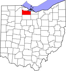 | |
| Villages | ||
| Townships | ||
| CDPs | ||
| Unincorporated communities | ||
| Footnotes | ‡This populated place also has portions in an adjacent county or counties | |