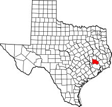
Magnolia, Texas
| Magnolia, Texas | |
|---|---|
| City | |
 Location of Magnolia, Texas | |
| Coordinates: 30°12′38″N 95°45′2″W / 30.21056°N 95.75056°WCoordinates: 30°12′38″N 95°45′2″W / 30.21056°N 95.75056°W | |
| Country | United States |
| State | Texas |
| County | Montgomery |
| Area | |
| • Total | 2.1 sq mi (5.4 km2) |
| • Land | 2.1 sq mi (5.4 km2) |
| • Water | 0.0 sq mi (0.0 km2) |
| Elevation | 269 ft (82 m) |
| Population (2010) | |
| • Total | 1,393 - (ETJ Area population is 1,500) |
| • Density | 528.3/sq mi (204.0/km2) |
| Time zone | Central (CST) (UTC-6) |
| • Summer (DST) | CDT (UTC-5) |
| ZIP codes | 77353-77355 |
| Area code(s) | 281/832 |
| FIPS code | 48-46056[1] |
| GNIS feature ID | 1340838[2] |
Magnolia is a city in southwestern Montgomery County, Texas, United States outside Houston and right next to The Woodlands. The population was 1,393 at the 2010 census. Settled in the late 1840s, the town has gone by several names including "Mink's Prairie" and "Mink".[3]
Geography
Magnolia is located at 30°12′38″N 95°45′2″W / 30.21056°N 95.75056°W (30.210476, -95.750631).[4] City limits encompass an area of approximately one square mile; much of this area is covered by a dense forest that fueled an earlier lumber industry. ETJ (Extraterritorial Jurisdiction) is 12 miles in all directions with an area population of more than 138,000.[3]
Demographics
| Historical population | |||
|---|---|---|---|
| Census | Pop. | %± | |
| 1970 | 315 | — | |
| 1980 | 867 | 175.2% | |
| 1990 | 940 | 8.4% | |
| 2000 | 1,111 | 18.2% | |
| 2010 | 1,393 | 25.4% | |
| Est. 2015 | 1,828 | [5] | 31.2% |
As of the census of 2010, there were 1,393 people, 529 households, and 365 families residing in the city. The population density was 528.3 people per square mile (204.3/km²).[1] There were 460 housing units at an average density of 218.7 per square mile (84.6/km²).[1] The racial makeup of the city was 81.3% White, 10.3% African American, 0.5% Native American, 0.8% Asian, 5.7% from other races, and 1.3% from two or more races.[1] Hispanic or Latino of any race were 11.7% of the population.[1]
There were 529 households out of which 49.9% had children under the age of 18 living with them, 44.9% were married couples living together, 18.5% had a female householder with no husband present, and 31.0% were non-families.[1] 25.7% of all households were made up of individuals.[1] The average household size was 2.63 and the average family size was 3.16.[1]
In the city the population was spread out with 29.7% under the age of 19, 5.9% from 20 to 24, 24.6% from 25 to 44, 26.3% from 45 to 64, and 13.6% who were 65 years of age or older.[1] The median age was 37.8 years.[1] For every 100 females there were 91.0 males. For every 100 females age 18 and over, there were 86.3 males.[1]
As of the census of 2000, the median income for a household in the city was $41,875, and the median income for a family was $50,417. Males had a median income of $45,083 versus $21,696 for females.[1] The per capita income for the city was $21,278.[1] About 8.1% of families and 9.0% of the population were below the poverty line, including 8.2% of those under age 18 and 13.5% of those age 65 or over.[1]
Government and infrastructure
In 2011 the citizenry voted to allow the sale of alcoholic beverages. Magnolia was the last "dry" city in Montgomery County.[7]
The United States Postal Service Magnolia Post Office is located at 815 Goodson Road.[8]
Education
Magnolia schools are operated by the Magnolia Independent School District. While the town itself may be small, the Magnolia School District covers 147 square miles (380 km2) of the surrounding countryside.[3] With more than 65,000 residents, Magnolia schools enrolled more than 8000 students in the 2008/2009 school year.[3] With the second fastest enrollment growth in the state, Magnolia has recently constructed a new high school and several elementary schools to meet demands for space.
The Montgomery County Memorial Library System operates the Malcom Purvis Branch in the city.
Climate
The climate in this area is characterized by hot, humid summers and generally mild to cool winters. According to the Köppen Climate Classification system, Magnolia has a humid subtropical climate, abbreviated "Cfa" on climate maps.[9]
References
- 1 2 3 4 5 6 7 8 9 10 11 12 13 14 "American FactFinder". United States Census Bureau. Archived from the original on 2013-09-11. Retrieved 2008-01-31.
- ↑ "US Board on Geographic Names". United States Geological Survey. 2007-10-25. Retrieved 2008-01-31.
- 1 2 3 4 "Magnolia Area Chamber of Commerce". Level 7 Solutions. Retrieved 2008-10-08.
- ↑ "US Gazetteer files: 2010, 2000, and 1990". United States Census Bureau. 2011-02-12. Retrieved 2011-04-23.
- ↑ "Annual Estimates of the Resident Population for Incorporated Places: April 1, 2010 to July 1, 2015". Retrieved July 2, 2016.
- ↑ "Census of Population and Housing". Census.gov. Archived from the original on May 11, 2015. Retrieved June 4, 2015.
- ↑ "Pasadena, Lamar OK bond issues." Houston Chronicle. Tuesday November 8, 2011. Retrieved on November 11, 2011.
- ↑ "Post Office Location - MAGNOLIA." United States Postal Service. Retrieved on December 6, 2008.
- ↑ Climate Summary for Magnolia, Texas
External links
| Wikimedia Commons has media related to Magnolia, Texas. |
