Majuro
| Majuro | |||||||||||||||
|---|---|---|---|---|---|---|---|---|---|---|---|---|---|---|---|
| Capital city | |||||||||||||||
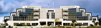
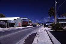
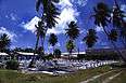
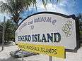
Republic of the Marshall Islands Capitol Building, main road of Majuro, Majuro Cooperative School, fisherman in Majuro, Marshallese alphabet in a public library, burial ground, downtown Majuro, welcome sign to Majuro, welcome sign to Eneko Island, palm tree in Majuro, sunset from Majuro, satellite picture of Majuro, Eneko Island panorama. | |||||||||||||||
| Elevation | 3 m (10 ft) | ||||||||||||||
| Population | 27,797 | ||||||||||||||
.jpg)


.jpg)
.jpg)
.jpg)
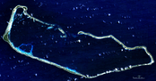
Majuro, /ˈmædʒəroʊ/ (Marshallese: Mājro, [mʲæzʲ(ɛ͡ʌ)rˠɤ͡oo̯]),[1] is the capital and largest city of the Republic of the Marshall Islands. It is also a large coral atoll of 64 islands in the Pacific Ocean. It forms a legislative district of the Ratak (Sunrise) Chain of the Marshall Islands. The atoll has a land area of 9.7 square kilometres (3.7 sq mi) and encloses a lagoon of 295 square kilometres (114 sq mi). As with other atolls in the Marshall Islands, Majuro consists of narrow land masses.
The main population center, named Delap-Uliga-Djarrit, DUD - three contiguous motus, had 20,301 people as of 2012. Majuro has a port, shopping district, hotels, and an international airport.
Geography

At the western end of the atoll, about 50 kilometres (30 mi) from D–U–D by road, is the island community of Laura, a growing residential area with a popular beach. Laura has the highest elevation point on the atoll, estimated at less than 3 metres (10 feet) above sea level.
Djarrit is mostly residential.
Climate
Being slightly north of the Equator, Majuro has a tropical climate with temperatures always above 21 °C (70 °F).
| Climate data for Majuro | |||||||||||||
|---|---|---|---|---|---|---|---|---|---|---|---|---|---|
| Month | Jan | Feb | Mar | Apr | May | Jun | Jul | Aug | Sep | Oct | Nov | Dec | Year |
| Average high °F (°C) | 85.5 (29.7) |
85.9 (29.9) |
86.1 (30.1) |
86.1 (30.1) |
86.4 (30.2) |
86.3 (30.2) |
86.4 (30.2) |
86.7 (30.4) |
86.9 (30.5) |
86.9 (30.5) |
86.6 (30.3) |
85.9 (29.9) |
86.3 (30.2) |
| Average low °F (°C) | 77.8 (25.4) |
77.9 (25.5) |
78.0 (25.6) |
78.1 (25.6) |
78.3 (25.7) |
77.9 (25.5) |
77.8 (25.4) |
77.9 (25.5) |
77.9 (25.5) |
77.8 (25.4) |
77.9 (25.5) |
77.7 (25.4) |
77.9 (25.5) |
| Average precipitation inches (mm) | 8.28 (210.3) |
7.62 (193.5) |
7.55 (191.8) |
9.63 (244.6) |
9.86 (250.4) |
10.93 (277.6) |
11.93 (303) |
11.42 (290.1) |
12.14 (308.4) |
13.27 (337.1) |
13.23 (336) |
11.56 (293.6) |
127.42 (3,236.5) |
| Average precipitation days (≥ 0.01 in) | 19.3 | 16.1 | 17.6 | 18.9 | 22.1 | 23.1 | 24.3 | 22.9 | 22.9 | 23.4 | 22.9 | 22.7 | 256.2 |
| Average relative humidity (%) | 77.7 | 77.1 | 79.0 | 80.7 | 81.9 | 81.1 | 80.5 | 79.3 | 79.4 | 79.4 | 79.9 | 79.7 | 79.6 |
| Mean monthly sunshine hours | 224.4 | 218.6 | 252.8 | 219.4 | 224.8 | 210.8 | 217.0 | 232.2 | 217.8 | 205.4 | 191.4 | 197.4 | 2,612 |
| Percent possible sunshine | 61 | 66 | 67 | 60 | 58 | 56 | 56 | 61 | 60 | 55 | 54 | 54 | 59 |
| Source: NOAA (relative humidity and sun 1961−1990)[2][3] | |||||||||||||
History

Humans have inhabited the atoll for at least 2,000 years.[4]
Majuro Atoll was claimed by the German Empire with the rest of the Marshall Islands in 1884, and the Germans established a trading outpost. As with the rest of the Marshalls, Majuro was captured by the Imperial Japanese Navy in 1914 during World War I and mandated to the Empire of Japan by the League of Nations in 1920. The island then became a part of the Japanese mandated territory of Nanyo; although the Japanese had established a government in Nanyo, local affairs were mostly left in the hands of traditional local leaders until the start of World War II.
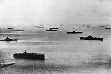
On January 30, 1944, United States troops invaded, but found that Japanese forces had evacuated their fortifications to Kwajalein and Enewetak about a year earlier. A single Japanese warrant officer had been left as a caretaker. With his capture, the islands were secured. This gave the U.S. Navy use of one of the largest anchorages in the Central Pacific. The lagoon became a large forward naval base of operations and was the largest and most active port in the world until the war moved westward when it was supplanted by Ulithi (Yap, Federated States of Micronesia).[5]
Following World War II, Majuro came under the control of the United States as part of the Trust Territory of the Pacific Islands. It supplanted Jaluit Atoll as the administrative center of the Marshall Islands, a status that it retains after the independence of the Marshall Islands in 1986.
Demographics
The major population centers are the D–U–D communities: the islets of Delap–Uliga–Djarrit (listed from south to north, on the eastern edge of the atoll). As of 2008, Majuro had a population of 27,797.[6]
Religion
Most of the population is Christian.[7] The majority follows the United Church of Christ. The Cathedral of the Assumption of the Roman Catholic Apostolic Prefecture of the Marshall Islands is located in Majuro.[8]
Islamic influence has been increasing. There is a sizable number of Ahmadi Muslims. The first mosque opened in Majuro in September 2012.[9]
There are also Mormon churches, Baptist churches, SDA churches, and the Salvation Army.
Economy
Majuro's economy is driven by the service sector.[7]
On September 15, 2007, Witon Barry, of the Tobolar Copra processing plant in the Marshall Islands' capital of Majuro, said power authorities, private companies and entrepreneurs had been experimenting with coconut oil as an alternative to diesel fuel for vehicles, power generators and ships. Coconut trees abound in the Pacific's tropical islands. Copra from 6 to 10 coconuts makes 1 litre of oil.[10]
Air Marshall Islands has its headquarters in Majuro.[11]
Education
Housed in Uliga are the College of the Marshall Islands, Assumption High School, and Uliga Elementary School where English is taught to all students.
The Marshall Islands High School is near the north end of Majuro.
The University of South Pacific has a presence on Majuro.[7]
Delap has the Seventh Day Adventist High School and Elementary School where English is taught to all students.[12]
Laura has the Seventh Day Adventist Elementary school where English is taught to all students.
Health
Majuro Hospital has 81 beds.[13] It is the main hospital for Majuro, as well as many of the outer islands.
In 2006, infant mortality was 3.0%.[7]
Average life expectancy at birth is 59 and 60 years for males and females respectively.[14]
Infrastructure
Water and Sewage
The Majuro Water and Sewer Company obtains water from a catchment on the International runway. It supplies 140,000,000 US gallons (530,000,000 l; 120,000,000 imp gal) a year or 14 US gallons (53 l; 12 imp gal) per person per day. This compares with New York City's 118 US gallons (450 l; 98 imp gal) per person per day. Water is supplied 12 hours daily. The threat of drought is commonplace.[15]
Transportation
Air
Marshall Islands International Airport, offering domestic and international services, is on Majuro Atoll. It is served by four passenger airlines: United Airlines, Our Airline, Air Marshall Islands, and Asia Pacific Airlines.[16]
Air Marshall Islands flies to most of the Marshalls' inhabited atolls once a week.[17] It offers daily service between Majuro and Kwajalein except Thursdays and Sundays.[18]
Boat
Majuro Lagoon is an active port. The Marshall Islands Shipping Corporation operates three ships (Aeaman, Langdrik, Ribuukae) and a landing craft (Jelejeletae). These vessels are the main link for transporting people and supplies to and from the outer islands.
Additionally, the lagoon acts as a harbor for commercial fishing vessels, cruisers, sport fishing boats, outrigger sailing canoes and the occasional luxury yacht.
Roads
Most of the roadway from Djarrit to Laura is a single two-lane paved road.
Sports
Majuro was initially scheduled to host the seventh edition of the Micronesian Games, in 2010. It subsequently renounced its hosting rights, citing a lack of adequate infrastructure.[19][20]
There is an olympic committee in Majuro. Weightlifter Mattie Langtor Sasser participated in the Rio 2016 summer olympics, competing in the Women’s 58Kg category on August 8.[21] She was competing for the Marshall Islands.
Twin towns – Sister cities
Majuro is twinned with:
References
- ↑ "M". trussel2.com. Retrieved 29 May 2015.
- ↑ "MH Majuro WBAS AP". National Oceanic and Atmospheric Administration. Retrieved 11 March 2015.
- ↑ "WMO climate normals for Majuro, PI 1961−1990". National Oceanic and Atmospheric Administration. Retrieved 11 March 2015.
- ↑ "The Natural history of Enewetak Atoll". Internet Archive. Retrieved 29 May 2015.
- ↑ "Eastern Mandates". army.mil. Retrieved 29 May 2015.
- ↑ "City population by sex, city and city type". UNdata.
- 1 2 3 4 "Marshall Islands". Office of Electronic Information, Bureau of Public Affairs. Retrieved 26 November 2011.
- ↑ "Cathedral of the Assumption". GCatholic.org. Retrieved 2013-01-15.
- ↑ First Mosque opens up in Marshall Islands by Radio New Zealand International, September 21, 2012
- ↑ "Pacific Islands look to coconut power to fuel future growth". afp.google.com.
- ↑ "Contact Information." Air Marshall Islands. Retrieved on October 6, 2010. "Headquarters P.O. Box 1319 Majuro, MH 96960."
- ↑ SSD
- ↑ "Health System Profile - Marshall Islands". cdc.gov. Retrieved 29 May 2015.
- ↑ "WHO - Marshall Islands". who.int. Retrieved 29 May 2015.
- ↑ Peter Meligard (December 28, 2015). "Perishing of Thirst In A Pacific Paradise". Huffington Post. Retrieved August 3, 2016.
- ↑ "Airlines Serving the Marshall Islands - RMIPA". Republic of the Marshall Islands Ports Authority. Retrieved 29 May 2015.
- ↑ "あこがれのタワーマンションの選び方". airmarshallislands.com. Retrieved 29 May 2015.
- ↑ Air Marshall Islands
- ↑ "Scaled down Micro Games in 2010", Jon Perez, Saipan Tribune, April 9, 2008
- ↑ "Two Northern Pacific countries vying for the right to host Micronesia Games". Radio New Zealand International. May 8, 2008. Retrieved October 19, 2011.
- ↑ "Mattie Sasser is lifted by Rio experience. - Marshall Islands National Olympic Committee - SportsTG". SportsTG. Retrieved 2016-10-31.
- ↑ "Taipei - International Sister Cities". Taipei City Council. Archived from the original on 2012-11-02. Retrieved 2013-08-23.
External links
| Wikimedia Commons has media related to Majuro. |
-
 Majuro travel guide from Wikivoyage
 - Marshall Islands site
- Entry at Oceandots.com at the Wayback Machine (archived December 23, 2010)
- Recent photos of the rural portions of Majuro
- World War II photos of Majuro
- Battle of Kwajalein and Enewetak
| ||
| Ratak Chain (Sunrise, Eastern) |  | |
| Ralik Chain (Sunset, Western) | ||
Coordinates: 7°04′N 171°16′E / 7.067°N 171.267°E