Malay, Aklan
| Malay | ||
|---|---|---|
| Municipality | ||
|
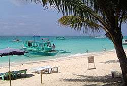
White Beach, Boracay Island | ||
| ||
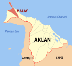 Location within Aklan province | ||
.svg.png) Malay Location within the Philippines | ||
| Coordinates: 11°54′N 121°55′E / 11.9°N 121.92°ECoordinates: 11°54′N 121°55′E / 11.9°N 121.92°E | ||
| Country | Philippines | |
| Region | Western Visayas (Region VI) | |
| Province | Aklan | |
| District | Lone District of Aklan | |
| Founded | June 15, 1949 | |
| Barangays | 17 (see Barangays) | |
| Government [1] | ||
| • Type | Sangguniang Bayan | |
| • Mayor | Ciceron Cawaling | |
| Area[2] | ||
| • Total | 66.01 km2 (25.49 sq mi) | |
| Population (2015 census)[3] | ||
| • Total | 52,973 | |
| • Density | 800/km2 (2,100/sq mi) | |
| • Voter (2016)[4] | 33,813 | |
| Time zone | PST (UTC+8) | |
| ZIP code | 5608 | |
| IDD : area code | +63 (0)36 | |
| Income class | 1st class | |
| PSGC | 060412000 | |
| Website |
foo | |

Malay, officially the Municipality of Malay (Aklanon: Banwa it Malay; Hiligaynon: Banwa sang Malay; Filipino: Bayan ng Malay), is a municipality in the province of Aklan in the Western Visayas (Region VI) of the Philippines. The population was 52,973 at the 2015 census.[3] In the 2016 election, it had 33,813 registered voters.[4]
The resort island Boracay is part of the municipality.
History
The municipality of Malay was created in the province of Capiz on June 15, 1949, from the barrio of Malay and surrounding barrios which were then part of Buruanga. The new municipality then included the following barrios: Malay (poblacion, seat of local government), Dumlog, Cabulihan, Balusbos, Nabaoy, Cubay Norte, Cubay Sur, Cogon, Argao, Sambiray, Caticlan, Manoc-Manoc, Balabag, Yapak, Motag, Napaan, and Naasog.[5] On April 25, 1956, Malay became a municipality of the newly created province of Aklan, along with several other towns of Capiz.[6]
It was hit severely by typhoon Seniang on 9–10 December 2006, with much destruction and damage of homes and infrastructure.
Proposed conversion to cityhood
"Resolution no. 066, series of 2010" created an ad hoc Committee and Technical Working Group to conduct initial study and evaluation for the proposed cityhood of the Municipality of Malay, Aklan.[7]
Geography
Malay is located at 11°54′N 121°55′E / 11.9°N 121.92°E.
According to the Philippine Statistics Authority, the municipality has a land area of 66.01 square kilometres (25.49 sq mi)[2] constituting 3.62% of the 1,821.42-square-kilometre- (703.25 sq mi) total area of Aklan.
Climate
| Climate data for Malay | |||||||||||||
|---|---|---|---|---|---|---|---|---|---|---|---|---|---|
| Month | Jan | Feb | Mar | Apr | May | Jun | Jul | Aug | Sep | Oct | Nov | Dec | Year |
| Average high °C (°F) | 28 (82) |
29 (84) |
29 (84) |
27 (81) |
32 (90) |
31 (88) |
29 (84) |
30 (86) |
31 (88) |
30 (86) |
29 (84) |
28 (82) |
29.4 (84.9) |
| Average low °C (°F) | 23 (73) |
24 (75) |
24 (75) |
23 (73) |
25 (77) |
25 (77) |
24 (75) |
25 (77) |
25 (77) |
25 (77) |
24 (75) |
24 (75) |
24.3 (75.5) |
| Average rainfall mm (inches) | 102 (4.02) |
27 (1.06) |
30 (1.18) |
129 (5.08) |
120 (4.72) |
237 (9.33) |
189 (7.44) |
186 (7.32) |
126 (4.96) |
231 (9.09) |
162 (6.38) |
90 (3.54) |
1,629 (64.12) |
| Average rainy days | 14 | 12 | 9 | 11 | 20 | 20 | 21 | 22 | 19 | 21 | 17 | 17 | 203 |
| Source: World Weather Online[8] | |||||||||||||
Barangays
Malay is politically subdivided into 17 barangays,[9]three (Balabag, Manoc-Manoc, and Yapak) of which are situated within Boracay Island, while the rest are in mainland Malay.
| PSGC | Barangay | Population | ±% p.a. | ||
|---|---|---|---|---|---|
| 2015[3] | 2010[10] | ||||
| 060412001 | Argao | 2.3% | 1,213 | 1,078 | +2.27% |
| 060412002 | Balabag | 23.2% | 12,296 | 11,076 | +2.01% |
| 060412003 | Balusbus | 2.5% | 1,310 | 1,079 | +3.76% |
| 060412004 | Cabulihan | 1.5% | 772 | 575 | +5.77% |
| 060412005 | Caticlan | 15.1% | 7,996 | 6,593 | +3.74% |
| 060412006 | Cogon | 1.2% | 647 | 544 | +3.36% |
| 060412007 | Cubay Norte | 0.7% | 365 | 327 | +2.12% |
| 060412008 | Cubay Sur | 2.7% | 1,423 | 1,153 | +4.09% |
| 060412009 | Dumlog | 1.6% | 863 | 768 | +2.25% |
| 060412010 | Manoc-Manoc | 28.0% | 14,810 | 12,526 | +3.24% |
| 060412017 | Motag | 1.7% | 903 | 818 | +1.90% |
| 060412011 | Naasug | 1.1% | 557 | 547 | +0.35% |
| 060412012 | Nabaoy | 2.3% | 1,220 | 1,025 | +3.37% |
| 060412013 | Napaan | 1.4% | 751 | 649 | +2.82% |
| 060412014 | Poblacion | 2.5% | 1,304 | 1,255 | +0.73% |
| 060412015 | San Viray | 2.6% | 1,382 | 1,031 | +5.74% |
| 060412016 | Yapak | 9.7% | 5,161 | 4,767 | +1.52% |
| Total | 52,973 | 45,811 | +2.80% | ||
Demographics
| Population census of Malay | |||||||||||||||||||||||||
|---|---|---|---|---|---|---|---|---|---|---|---|---|---|---|---|---|---|---|---|---|---|---|---|---|---|
|
| ||||||||||||||||||||||||
| Source: PSA[3][10][11] | |||||||||||||||||||||||||
In the 2015 census, Malay had a population of 52,973.[3] The population density was 800 inhabitants per square kilometre (2,100/sq mi).
In the 2016 election, it had 33,813 registered voters.[4]
Economy
Because of its robust tourism industry, the municipality is now considered as having the strongest economy in all the municipalities in the Region and the richest municipality of Aklan in terms of income and annual budget.[12] The tourism industry of Boracay became the catalyst of its economic growth that brought many investors to come and helped transform the municipality into a cosmopolitan area.
Banks
As of 2016, there are ten (10) banks in the municipality of Malay operated by six (6) commercial banking corporations.
Transportation
Air
Malay has one airport, officially named Godofredo P. Ramos Airport but more popularly known as Caticlan Airport. Only small aircraft are allowed to land on the 810 m (2,660 ft) runway. Most airlines have also restricted weight allowance since the airplanes are small. Nearby Kalibo International Airport with its 2,300 m (7,500 ft) runway is able to accommodate larger aircraft. As of November 2016, it can now accommodate larger aircraft like an Airbus A320 or a Boeing 737.
Sea
The Caticlan Jetty Port, one of the ports along the Strong Republic Nautical Highway, serves as a gateway to Boracay island and Roxas, Oriental Mindoro.
Schools
Elementary
- Argao Elementary School
- Balabag Elementary School
- Caticlan Elementary School
- Cubay Elementary School
- Dumlog/Kabulihan Primary School
- Malay Elementary School
- Manoc-Manoc Elementary School
- Naasug Primary School
- Nabaoy Elementary School
- Napaan Primary School
- Sambiray Primary School
- Yapak Elementary School
Secondary
- Boracay National High School
- Boracay National High School Manoc-Manoc Extension
- Lamberto H. Tirol National High School
- Malay National High School
Elementary/Secondary
- Bloomfield Integrated Academy
- Boracay European International School
- Boracay Island Global Academy
- Canadian Tourism & Hospitality Institute
- Caticlan Academy Foundation, Inc.
- Caticlan Conferey School
- Goshen School of Technology and Humanities, Inc.
- Mission of Love Integrated School, Inc.
- Mountain of God Academy, Inc.
- NVC International School
- Paradise English Boracay Language Institute
- River of Knowledge Foundation, Inc.
Health
Malay is being served by three (3) hospitals, of which 1 is private, and 2 are owned by the government.
- Don Circiaco Tirol Memorial Hospital
- Malay Municipal Hospital
- Aklan Baptist Hospital
References
- ↑ "Municipality". Quezon City, Philippines: Department of the Interior and Local Government. Retrieved 31 May 2013.
- 1 2 "Province: Aklan". PSGC Interactive. Makati City, Philippines: Philippine Statistics Authority. Retrieved 28 October 2016.
- 1 2 3 4 5 "Region VI (WESTERN VISAYAS)". Census of Population (2015): Total Population by Province, City, Municipality and Barangay (Report). PSA. Retrieved 20 June 2016.
- 1 2 3 "2016 National and Local Elections Statistics". Commission on Elections. 2016.
- ↑ "Republic Act No. 381; an Act Creating the Municipality of Malay in the Province of Capiz". PhilippineLaw.info. 15 June 1949. Archived from the original on 22 October 2014. Retrieved 20 October 2016.
- ↑ "Republic Act No. 1414 - An Act To Create the Province of Aklan". Chan Robles Virtual Law Library. 25 April 1956. Archived from the original on 4 March 2016. Retrieved 21 October 2016.
- ↑ Approved SB, DTD. 11-30-10
- ↑ "Malay, Philippines: Average Temperatures and Rainfall". World Weather Online. Retrieved 15 September 2014.
- ↑ "Municipal: Malay, Aklan". PSGC Interactive. Quezon City, Philippines: Philippine Statistics Authority. Retrieved 8 January 2016.
- 1 2 "Region VI (WESTERN VISAYAS)". Census of Population and Housing (2010): Total Population by Province, City, Municipality and Barangay (Report). NSO. Retrieved 29 June 2016.
- ↑ "Region VI (WESTERN VISAYAS)". Census of Population (1995, 2000 and 2007): Total Population by Province, City and Municipality (Report). NSO. Archived from the original on 24 June 2011.
- ↑ Bandiol, Odon S. "Aklan SP reviews Malay P310-M 2013 budget". Panay News. Archived from the original on 10 August 2013. Retrieved 21 October 2016.
External links
| Wikimedia Commons has media related to Malay, Aklan. |
 |
Tablas Strait | San Jose, Romblon Sibuyan Sea |
| |
| |
Nabas | |||
| ||||
| | ||||
| Buruanga | Libertad, Antique |
Kalibo (capital) | |
| Municipalities | |