Aklan
| Aklan | |||
|---|---|---|---|
| Province | |||
| Province of Aklan | |||
| |||
| Anthem: "Aklan Hymn" | |||
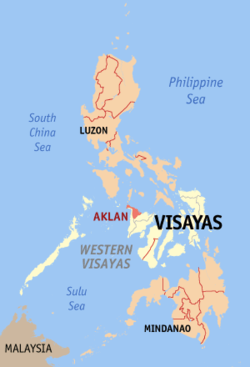 Location in the Philippines | |||
| Coordinates: 11°40′N 122°20′E / 11.67°N 122.33°ECoordinates: 11°40′N 122°20′E / 11.67°N 122.33°E | |||
| Country | Philippines | ||
| Region | Western Visayas (Region VI) | ||
| Founded | 25 April 1956 | ||
| Capital | Kalibo | ||
| Government | |||
| • Type | Sangguniang Panlalawigan | ||
| • Governor | Florencio Miraflores (Liberal) | ||
| • Vice Governor | Gabrielle Calizo-Quimpo (Nacionalista) | ||
| Area[1] | |||
| • Total | 1,821.42 km2 (703.25 sq mi) | ||
| Area rank | 64th out of 81 | ||
| Population (2015 census)[2] | |||
| • Total | 574,823 | ||
| • Rank | 53rd out of 81 | ||
| • Density | 320/km2 (820/sq mi) | ||
| • Density rank | 23rd out of 81 | ||
| Divisions | |||
| • Independent cities | 0 | ||
| • Component cities | 0 | ||
| • Municipalities | |||
| • Barangays | 327 | ||
| • Districts | Lone district of Aklan | ||
| Time zone | PHT (UTC+8) | ||
| ZIP Code | 5600–5616 | ||
| IDD : area code | +63 (0)36 | ||
| ISO 3166 code | PH-AKL | ||
| Spoken languages | |||
| Website |
www | ||


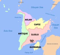
Aklan (Akean) (Aklanon pronunciation: [ak'ɤan]) is a province in the Philippines located in the Western Visayas region. Its capital is Kalibo. The province is situated in the northwest portion of Panay Island, bordering Antique to the southwest, and Capiz to the east. Aklan faces the Sibuyan Sea and Romblon province to the north.
History
Aklan is believed to have been settled in the 12th century by settlers from Borneo, ruled by the chieftain Datu Dinagandan which traded with its neighbouring islands. Aklan then became a part of the Kedatuan of Madja-as.
Towards the end of the 14th century, Datu Dinagandan moved the capital from what is now Batan. In 1433, Datu Kalantiaw's grandson and successor, Datu Kalantiaw III, was said by Jose Marcos to have formulated a set of laws known today as the Code of Kalantiaw. Well respected scholarly long-term Philippine resident historian William Henry Scott, proved these "laws" to be a total fabrication.[3][4][5][6] In 1437, the short-lived dynasty of Datu Kalantiaw ended when Datu Kalantiaw III was killed in battle with the tribes of Datu Manduyog, the legitimate successor of Datu Dinagandan. When Datu Manduyog became the new chieftain, he moved the capital to Bakan (now known as Banga).
Several datus succeeded Datu Manduyog until the Spanish explorer Miguel López de Legazpi landed in Batan in 1565 and claimed the island for Spain, in early Spanish accounts it was called El Río de Aclán. Datu Kabanyag was the chieftain at that period and had his capital in Libacao.
In 1942, the Japanese invaded Aklan during World War II and in 1945, combined Filipino and American army along with Aklanon guerrillas liberated Aklan during the war in the Pacific.
Aklan became an independent province through Republic Act No. 1414 signed by Philippine President Ramon Magsaysay on April 25, 1956, separating Aklan from Capiz.[7] The original towns were Altavas, Balete, Batan, Banga, Buruanga, Ibajay, Kalibo, Lezo, Libacao, Madalag, Malay, Makato, Malinao, Nabas, New Washington, Numancia, and Tangalan, then all part of the province of Capiz. The province was inaugurated on November 8, 1956. José Raz Menez was appointed the first governor of Aklan by President Magsaysay and he served until December 30, 1959. In 1960, Godofredo P. Ramos became the first elected governor but upon resigning to run for Congress he was succeeded by the vice governor, Virgilio S. Patricio. In 1964, José B. Legaspi succeeded Patricio and he held office for two consecutive terms from 1964 to 1971.
Geography
Aklan occupies the northern third of the island of Panay and is bordered by the provinces of Iloilo from the south, Capiz from the east and Antique from the southwest. It also faces the Sibuyan Sea from the north. The province covers a total area of 1,821.42 square kilometres (703.25 sq mi)[8], and includes the island of Boracay which is located at its northwestern tip.
The province features high geographic diversity, ranging from white sandy beaches, mangroves and mountainous landscapes. Situated within the province is the river Akean, which appears unique due to its "boiling or frothing" appearance.
Administrative divisions
Aklan comprises 17 municipalities.[8] A single congressional district encompasses all towns.[8]
| Municipality[lower-roman 1] | Population | ±% p.a. | Area[8] | Density (2015) | Brgy. | |||||||
|---|---|---|---|---|---|---|---|---|---|---|---|---|
| (2015)[2] | (2010)[9] | km2 | sq mi | /km2 | /sq mi | |||||||
| 11°32′14″N 122°29′17″E / 11.5373°N 122.4881°E | Altavas | 4.3% | 24,619 | 23,919 | +0.55% | 109.05 | 42.10 | 230 | 600 | 14 | ||
| 11°33′23″N 122°22′47″E / 11.5564°N 122.3797°E | Balete | 5.0% | 28,920 | 27,197 | +1.18% | 118.93 | 45.92 | 240 | 620 | 10 | ||
| 11°38′18″N 122°19′56″E / 11.6382°N 122.3322°E | Banga | 6.9% | 39,505 | 38,063 | +0.71% | 84.53 | 32.64 | 470 | 1,200 | 30 | ||
| 11°35′13″N 122°29′46″E / 11.5869°N 122.4962°E | Batan | 5.6% | 32,032 | 30,312 | +1.06% | 79.22 | 30.59 | 400 | 1,000 | 20 | ||
| 11°50′39″N 121°53′18″E / 11.8442°N 121.8884°E | Buruanga | 3.3% | 19,003 | 16,962 | +2.19% | 88.50 | 34.17 | 210 | 540 | 15 | ||
| 11°49′06″N 122°09′54″E / 11.8184°N 122.1649°E | Ibajay | 8.6% | 49,564 | 45,279 | +1.74% | 158.90 | 61.35 | 310 | 800 | 35 | ||
| 11°42′32″N 122°21′50″E / 11.7089°N 122.3640°E | Kalibo | † | 14.0% | 80,605 | 74,619 | +1.48% | 50.75 | 19.59 | 1,600 | 4,100 | 16 | |
| 11°40′04″N 122°19′43″E / 11.6679°N 122.3286°E | Lezo | 2.6% | 15,224 | 14,518 | +0.91% | 23.40 | 9.03 | 650 | 1,700 | 12 | ||
| 11°28′50″N 122°18′09″E / 11.4806°N 122.3024°E | Libacao | 4.9% | 28,241 | 28,005 | +0.16% | 254.98 | 98.45 | 110 | 280 | 24 | ||
| 11°31′37″N 122°18′23″E / 11.5269°N 122.3063°E | Madalag | 3.2% | 18,389 | 18,168 | +0.23% | 269.60 | 104.09 | 68 | 180 | 25 | ||
| 11°42′42″N 122°17′33″E / 11.7116°N 122.2926°E | Makato | 4.7% | 27,262 | 25,461 | +1.31% | 64.60 | 24.94 | 420 | 1,100 | 18 | ||
| 11°54′01″N 121°54′36″E / 11.9002°N 121.9100°E | Malay | 9.2% | 52,973 | 45,811 | +2.80% | 66.01 | 25.49 | 800 | 2,100 | 17 | ||
| 11°38′38″N 122°18′27″E / 11.6439°N 122.3076°E | Malinao | 4.0% | 23,194 | 24,108 | −0.73% | 186.01 | 71.82 | 120 | 310 | 23 | ||
| 11°49′44″N 122°05′36″E / 11.8288°N 122.0933°E | Nabas | 6.3% | 36,435 | 31,052 | +3.09% | 96.82 | 37.38 | 380 | 980 | 20 | ||
| 11°38′50″N 122°26′08″E / 11.6473°N 122.4356°E | New Washington | 7.8% | 45,007 | 42,112 | +1.27% | 66.69 | 25.75 | 670 | 1,700 | 16 | ||
| 11°42′21″N 122°19′41″E / 11.7058°N 122.3280°E | Numancia | 5.6% | 31,934 | 29,862 | +1.29% | 28.84 | 11.14 | 1,100 | 2,800 | 17 | ||
| 11°46′26″N 122°15′37″E / 11.7740°N 122.2604°E | Tangalan | 3.8% | 21,916 | 20,277 | +1.49% | 74.59 | 28.80 | 290 | 750 | 15 | ||
| Total | 574,823 | 535,725 | +1.35% | 1,821.42 | 703.25 | 320 | 830 | 327 | ||||
| † Provincial capital | Municipality | |||||||||||
| ||||||||||||
Demographics
| Population census of Aklan | ||
|---|---|---|
| Year | Pop. | ±% p.a. |
| 1990 | 380,497 | — |
| 1995 | 410,539 | +1.43% |
| 2000 | 451,314 | +2.05% |
| 2007 | 495,122 | +1.29% |
| 2010 | 535,725 | +2.91% |
| 2015 | 574,823 | +1.35% |
| Source: National Statistics Office[2][9][9] | ||
The population of Aklan in the 2015 census was 574,823 people,[2] with a density of 320 inhabitants per square kilometre or 830 inhabitants per square mile.
Ethnic groups
The main inhabitants of the province are the Aklanon, who are part of the Visayan ethnic group. Other inhabitants include the Negrito, locally known as the Ati and the Sulod, a lesser known tribal group living in the hinterlands of Panay. Other Visayans also present are the Karay-a, the Hiligaynon and the Capiznon.
Based on the 2000 census survey, Aklanon comprised 96.56% (434,869) of the total provincial population of 450,353. Other ethnic groups in the province were the Hiligaynon at 1.86% (8,375), Tagalog at 0.5% (2,271), Kankanaey at 0.28% (1,281), and Cebuano at 0.21% (939).[10]
Languages
The most prominent languages in the province are Akeanon (Aklanon Proper), Malaynon, and Buruanganon. Akeanon is spoken by a majority of the people, while Malaynon is spoken in Malay and Buruanganon is spoken in Buruanga. Other regional languages used include:
Religion
Roman Catholicism is the dominant religion of the people and Christian festivals such as Christmas and Lent are regarded with high importance. Meanwhile, Christian icons such as the Santo Niño are regarded as cultural symbols of the people. Animism, however, is still practised by the Ati. The Aglipayan Church or the Philippine Independent Church is the second most predominant religion in the province. Other religions in the province include Iglesia ni Cristo and Islam.
Economy

The province of Aklan is designated as a first class province.[8]
Agriculture
Aklan depends on agriculture, with palay being the top produce in the province. Rice plantations had an area of 42,218 hectares (104,320 acres) (0.39 percent of the total provincial agricultural area).[11]
With the implementation of the Ginintuang Masaganang Ani (GMA) rice production program using the Hybrid rice, production is expected to increase by 15 percent or an average of 10 metric tons per hectare in the succeeding years. However, the problem of low price support for rice still continues to affect the production sector.
In general, Aklan is sufficient in meat and other livestock and poultry products,[11] though in the inventory of livestock and poultry in the year 2000, hog and chicken had a decrease in population from 114,890 heads of hogs and 886,597 heads of chickens in 1999 to 95,950 heads of hogs and 782,820 heads of chicken in the 2000. The decrease in production were attributed to the following factors: high cost of feeds, feed supplements and biologics; livestock and poultry diseases; increasing price of chicks; and, high cost of labor.
Coconut still occupies the largest area planted among major permanent agriculture crops. The total area planted with coconut is 32,276 hectares (79,760 acres).[11] Ibajay ranks the largest with 4,317 hectares (10,670 acres); followed by Balete with 2,611 hectares (6,450 acres); Banga with 2,314 hectares (5,720 acres); Makato with 2,089 hectares (5,160 acres); and, Altavas with 2,054 hectares (5,080 acres). All the rest of the municipalities have areas below 2,000 hectares (4,900 acres). However, in terms of copra production, Makato ranks number one with 2,770 metric tons per year; next is Balete with 2,669; and Libacao with 2,399. The rest produce less than 2000 metric tons. Total production is 25,375 metric tons annually.
Other crops produced include banana (Lakatan), mango, rambutan, and lanzones; and fiber crops such as piña fiber and abaca.[11]
Aquaculture
Fishpond areas had a total area of 7,807.14 hectares (19,291.9 acres).[11] Of the total fishpond areas, 4,512.04162 hectares (11,149.4977 acres) are with Fishpond Lease Agreement (FLA); 138.85672 hectares (343.1224 acres) are with permits; 2,729.02636 hectares (6,743.5710 acres) are on process/application; and, 370.0 hectares (914 acres) are titled.
Industry
Aklan is a top producer of abaca,[12] which are dyed and made into cloths or place mats, bags, wall decors and fans.[11]
The piña cloth, considered as the "Queen of the Philippine Fabrics", is a prime produce of Kalibo, weaved from its unique crude wooden or bamboo handloom.[11]
Lezo is known for its red clay, used by the natives to make pots, vases and various novelty items.[11]
Transportation
Airports
Aklan is famous for Boracay, a resort island 1 kilometre (0.62 mi) north from the tip of Panay. It is known for its white sandy beaches and is considered as one of the more prominent destinations in the Philippines. Because of this, there is frequent air travel to the province's airports in Kalibo and Caticlan. Kalibo International Airport is about ten minutes from the main plaza. Kalibo Airport serve direct flights to and from Taipei; Hong Kong; Shanghai and Beijing in China; Incheon, Busan, and Chengdu through international flights served by Air Asia Zest Airways, ANA, Jin Air, Tiger Air Philippines, Etihad Airlines and PAL Express, Cebu Pacific Air and Philippine Airlines.
The following are the airports in Aklan:
- Kalibo International Airport (under CAAP)
- Godofredo P. Ramos Airport (under PPP with San Miguel Corporation)
Seaports
The following are the seaports in the province:
- Alegria Port
- Batan Port
- Cagban Port
- Caticlan Jetty Port
- Colong-Colong Port
- Dumaguit Port
- Kalibo Jetty Port (Proposed)
- New Washington Port
Culture
Despite the prevalence of Christianity, native beliefs about the aswang and the babaylan are still prevalent among the people. Kulam or witchcraft, locally known as amulit is still feared by many residents.
Festivals
The province is known for its festivities which includes the Ati-Atihan festival in Kalibo.[13] Originally, the festival was to celebrate the treaty between the Ati and the Malayan tribes who settled in the Island. The Ati live in the mountain regions and the Malay people in the flatlands or close to the water. The festivity begins on the dry season, at which time the Ati come down from the mountains to trade and celebrate with the Malayan tribes. When the Spaniards settled in the region and converted the Malays to their Christian religion, they asked the Malays to celebrate this festivity to coincide with the Feast of the Santo Niño (Holy Child) which is usually held during the third week of January.
Bariw Festival is a unique festival showcasing the skills of every Nabasnon in weaving bags, mats and hats made of bariw leaves - the prospering livelihood in the municipality. It is highlighted by the dance performance of local talent and ingenuity to the beat of the drums and indigenous rhythm celebrated every May 14 of the year.
Bugna Festival is a festival showcasing the different locally produced products and eco-tourism destinations of Tangalan like the marine sanctuary and coral garden, Afga Point, Campo Verde, Jawili Falls, Bughawi beach and reforestation project every May 16 of the year.
Kali-Ugyon Festival (kali stands for Kalipayan or happiness and Ugyon meaning "unity"). This is the festival celebrated in Libacao every December 30 to January 1, costumed in modern and indigenous outfits bringing people together on the streets for merry-making and to drive away evil spirits in the coming New Year.
Literature
Aklanons are known for their literature, which includes the epic of Kalantiao. Certain Aklanons, such as Melchor F. Cichon, Roman Aguirre, have produced several notable literary works in the province.
Universities and colleges
Aklan is the home of the Regional Science High School for Region VI (RSHS-VI), one of the specialized system of public secondary schools in the Philippines.
- Aklan Catholic College — Andagao
- Aklan Catholic College — Kalibo Poblacion
- Aklan Polytechnic College — Kalibo
- Aklan Polytechnic College — New Washington
- Aklan State University — Banga (Main)
- Aklan State University — Ibajay
- Aklan State University — Kalibo
- Aklan State University — Makato
- Aklan State University — New Washington
- Altavas Colleges
- Balete Community College
- Batan Community College
- Canadian Tourism & Hospitality Institute — Boracay
- Carillo Culinary Arts and Skills Development Center
- Central Panay College of Science and Technology
- FEATI University — Kalibo
- Garcia College of Technology-Annex
- Garcia College of Technology-Capitol Site
- Madyaas Intsitute
- Numancia Intergrated School(NIS)
- JAVTES College — Kalibo
- Lezo Technical College
- Montfort Technical Institute
- New OFW Vocational and Technical School
- Northwestern Visayan Colleges
- Numancia National School of Fisheries
- Panay Technological College
- Provincial Academic Center College of Nursing
- Saint Gabriel College
- Saint Anne Business School
- STI College of Kalibo
- Santo Niño Seminary
- Verde Grande Culinary School
- Western Pacific College
Fauna

Several species endemic to the Philippines are found in the province. Examples include endangered animals such the Philippine spotted deer (Cervus alfredi), the Visayan warty pig (Sus cebifrons), and the Visayan hornbill (Penelopides panini). As of 2007, conservation efforts are being made by the Aklan State University and the DENR with varying success.
See also
References
- ↑ "List of Provinces". PSGC Interactive. Makati City, Philippines: National Statistical Coordination Board. Retrieved 5 February 2013.
- 1 2 3 4 "Region VI (WESTERN VISAYAS)". Census of Population (2015): Total Population by Province, City, Municipality and Barangay (Report). PSA. Retrieved 20 June 2016.
- ↑ "The Fraudulent Code of Kalantiáw". Archived from the original on 18 June 2007. Retrieved 2007-07-09.
- ↑ Augusto V. de Viana (2006-09-17). "The Order of Kalantiaw? Haosiao!". The Sunday Times. Archived from the original on 2007-09-15. Retrieved 2007-07-09. (archived from the original on 2007-09-15)
- ↑ Scott, William Henry (1984). Prehispanic Source Materials for the study of Philippine History. New Day Publishers. pp. 132–134. ISBN 971-10-0226-4.
- ↑ Agoncillo, Teodoro C. (1990) [1960]. "History of the Filipino People" (8th ed.). Quezon City: Garotech Publishing: 26–28. ISBN 971-8711-06-6.
- ↑ "Republic Act No. 1414 - An Act to Create the Province of Aklan". Chan Robles Virtual Law Library. 25 April 1956. Retrieved 18 March 2016.
- 1 2 3 4 5 "Province: Aklan". PSA. Philippines: National Statistical Coordination Board. Retrieved 8 January 2016.
- 1 2 3 "Region VI (WESTERN VISAYAS)". Census of Population and Housing (2010): Total Population by Province, City, Municipality and Barangay (Report). NSO. Retrieved 29 June 2016.
- 1 2 "Aklan: Population Growth Rate up to 2.05 Percent in 2000; Table 5. Household Population by Ethnicity and Sex: Aklan, 2000". Philippine Statistics Authority. 24 July 2002. Archived from the original on 21 April 2015. Retrieved 26 July 2016.
- 1 2 3 4 5 6 7 8 "Economy". Province of Aklan. Retrieved 18 March 2016.
- ↑ Villanueva, Venus G. "Aklan still among top abaca producers in Phl". The Daily Guardian. Retrieved 18 March 2016.
KALIBO, Aklan – The province of Aklan continues to be one of the country’s top 10 abaca producers, according to Aklan Governor Carlito S. Marquez. Abaca fiber production in Aklan also rose by 50.89 percent in 2011, which reached 1,874,691 kilograms in 2011, with an estimated value of P75 million. Production in 2010 was 1,242,344 kilograms.
- ↑ "Vibrant Kalibo". Province of Aklan (official government website). Archived from the original on 18 March 2016. Retrieved 26 July 2016.
External links
-
 Media related to Aklan at Wikimedia Commons
 -
 Aklan travel guide from Wikivoyage
 -
 Geographic data related to Aklan at OpenStreetMap
 - The Official Website of the Provincial Government of Aklan
- The Official Website of Kalibo Ati-atihan Festival
- ABS-CBN Choose Philippines travel guide to Aklan
 |
Tablas Strait | Romblon Sibuyan Sea |
| |
| Antique | |
Sibuyan Sea | ||
| ||||
| | ||||
| Capiz |
Kalibo (capital) | |
| Municipalities | |