Manhattan Valley
Manhattan Valley is a neighborhood on the Upper West Side of Manhattan in New York City, bounded by West 110th Street to the north, Central Park West to the east, West 96th Street to the south, and Broadway to the west.[1] It was formerly known as the Bloomingdale District, a name still in occasional use.
Geography and boundaries
Manhattan Valley occupies a natural depression running east-west across Manhattan, declining rapidly from high rocky bluffs at the western border of modern Central Park, and following west the valley created by what was once a minor stream draining from roughly the area of the Harlem Meer into the Hudson River.[2] The area is located on a gentle slope between West 96th Street and W. 105th Street.[3]
A division preferred by community groups extends the area south to W. 96th Street,[1][3] a major thoroughfare which runs in its own natural valley and stretches across town through Central Park.[3]
From west to east, Broadway, Amsterdam Avenue, Columbus Avenue, Manhattan Avenue, and Central Park West are north-south thoroughfares through the neighborhood. Amsterdam Avenue, Broadway, and Central Park West proceed in an uninterrupted grid; Columbus Avenue becomes Morningside Drive north of W. 110th Street Manhattan Avenue originates at 100th Street and proceeds north into Harlem.[4] Several large swaths of Manhattan Valley are made up of residential developments which break the regular city street grid. The area from W. 100th to W. 97th Streets between Central Park West and Amsterdam Avenue consists of Park West Village, a "towers in a park" housing development. Another superblock, occupied by the Frederick Douglass Houses lies just to the north, bordered by Amsterdam Avenue, W. 100th Street, Manhattan Avenue, and West 104th Street. Columbus Avenue also passes through both of these developments.[4]
History
Development
Manhattan Valley was part of the Bloomingdale District, the name given to the farms and houses along the Bloomingdale Road along Manhattan's Upper West Side. The Dutch applied the name Bloemendaal, Anglicized to "Bloomingdale" or "the Bloomingdale District", to the west side of Manhattan from about 23rd Street up to the Hollow Way (modern 125th Street). It consisted of farms and villages along a road (regularized in 1703) known as the Bloomingdale Road. Bloomingdale Road was renamed The Boulevard in 1868, as the farms and villages were divided into building lots and absorbed into the city.[2][5]
By the 18th century it contained numerous farms and country residences of many of the city's well-off, a major parcel of which was the Apthorp Farm. The main artery was the Bloomingdale Road, which began north of where Broadway and the Bowery Lane (now Fourth Avenue) join (at modern Union Square) and wended its way northward to about modern 116th Street in Morningside Heights, where the road further north was known as the Kingsbridge Road. Within the confines of the modern-day Upper West Side, the road passed through the hamlets of Harsenville, bounded by 68th Street, 81st Street, Central Park West, and the Hudson River;[6] Strycker's Bay, located on a now-infilled inlet between 86th and 96th Streets;[7] and Bloomingdale Village, a place near current Columbia University campus.[8]
In the early 1800s, John Clendening owned a farm covering much of the valley, roughly from the Bloomingdale Road to Eighth Avenue between 99th and 105th Streets, with a large mansion near Amsterdam and 104th Streets.[9][note 1] The area was known as the "Clendening Valley."[10] Although the Clendening estate was divided and sold in 1845,[11] the Clendening Valley name persisted until the 1880s, and a Clendening Hotel existed into the early 20th century.[11]
The construction of an elevated aqueduct to carry the Croton Aqueduct over the valley in 1838-42 separated the eastern side of the valley from the village of Bloomingdale which had emerged around the Bloomingdale Road, until the 1870s when it was replaced with an underground inverted siphon, and the old aqueduct was torn down.[12][13] Early development in the 1870s and 1880s focused on institutional care for the ill or aged, and included the Hebrew Home for the Aged, the Catholic Old Age Home, the Home for Respectable Aged Indigent Females, and the Towers Nursing Home constructed as a cancer ward by John Jacob Astor III in 1884.[12][14] Also located in Manhattan Valley at the time was the New York Cancer Hospital, built in 1887 at 455 Central Park West.[12][15] These, together with the Lion Brewery, gave the area its earliest landmarks. The neighborhood began to fill out residentially at the end of the 19th century and beginning of the 20th, when the New York City Subway's IRT Ninth Avenue Line in 1870 and the IRT Broadway – Seventh Avenue Line in 1904 allowed the public ready access to uptown Manhattan. Columbia's purchase of the Bloomingdale Lunatic Asylum at around the same time as the subway's arrival naturally made the neighborhood more attractive as well.[2]
The area was populated mostly by Irish and German immigrants through the 1950s.[12] Young boys and girls took advantage of Central Park and Riverside Drive or played stick ball and roller hockey in the streets. The 1950s saw many immigrants from Puerto Rico take up residence in the Upper West Side and a proposed project to eliminate the older brownstone apartments began to drive earlier residents to the suburbs.[16]
Later years
By the 1950s and 1960s, the area went into decline, in line with a trend of general urban deterioration in Manhattan.[17] Urban renewal programs, headed by city planner Robert Moses, called for several city blocks to be demolished in order to construct the Frederick Douglass Houses in the superblock where they stand today.[18] However, rampant graft and corruption associated with the project blighted their opening and brought ill repute on the neighborhood, and the debacle contributed strongly to Moses's fall from power and ouster.[17] Although community groups, such as the Manhattan Valley Development Corporation, tried to find alternative solutions for the housing shortage in the area, the city's 1976 fiscal crisis caused many of these alternate plans to be shelved.[17]
With the Wall Street boom in the early 1980s, Manhattan as a whole experienced a sharp recovery. Seventy years after the Bloomingdale Asylum's closing, the provenance of the name was fading into obscurity, and residents and brokers alike began referring to the neighborhood by its present name.[19] The new name and recovery were both much bolstered by the non-profit Manhattan Valley Development Corporation (MVDC), founded in 1968. It sought to differentiate itself from other community development organizations by opposing the demolition of pre-war buildings in favor of renovation, and seeking to promote small business and "prevent harassment by out-side management companies prevalent in low income 'minority' neighborhoods."[20][21] Soon, however, new investment was brought to a halt by wavering property prices in the late 1980s and early 1990s, combined with the rise of crack use and dealers in the area, which gave Manhattan Valley the reputation as one of the easiest places in the city to score a hit.[21] In addition, there was a lot of violence on the streets of Manhattan Valley, especially at night, when gang wars were prevalent.[21]
Gentrification
Manhattan Valley has gentrified significantly since the 1980s.[22] With this gentrification, rents in the area rose. The population of estimated Latino residents was fast dwindling by 1987.[16] Meanwhile, nonprofit groups started to renovate many structures that were owned by the city, as well as build housing on previously vacant tracts of land.[21] Reactions to this gentrification were mixed. In 1990, one resident stated, "The crime situation is our biggest threat … but if we get rid of it, we're also faced with gentrification."[21] Coinciding with this gentrification in 1990, crime was declining steeply, although drug dealings were still common; one large drug arrest had been made in December of that year. The Frederick Douglass Houses, which had become frequented by drug dealers, was thought to be stymieing the development of new housing in the area, which included two apartment towers that had been constructed in the preceding two years.[21]
The Columbus Amsterdam business improvement district was organized in the late 1990s to develop stronger business presence along the main thoroughfares of Columbus and Amsterdam Avenues, and to provide entrepreneurial opportunities to locals.[23]
In 2005, brokers estimated that properties in the area were approximately 30% less expensive than comparable properties in the adjacent south.[24] The neighborhood's proximity to the much-valued Central Park as well as to three separate subway lines make it attractive to young commuters, and as of 2006 prices were rising dramatically as New Yorkers were "tipped off" by their brokers.[22] Many historical brownstones and townhouses were saved from demolition, particularly east of Columbus Avenue, where the property values are the highest.[21] Yet the area remains heavily diverse, representing a microcosm of the larger city in terms of the different ethnicities, ages and socioeconomic groups living within the same community.[17]
Demographics
According to the 2000 census (in which Manhattan Valley's census tracts are 187, 189, 191, 193, and 195), 48,983 people live in the community. Of the population, 44% are of Hispanic origin, 32% are African Americans, and 24% are Asians, whites, and other races. Fifty-five percent of the residents are of very low income (below 50% of the area's median family income, which is $13,854). The more affluent families reside West of Broadway (which is not Manhattan Valley) and East of Manhattan Avenue. Of the Manhattan Valley population, 20.76% are on Social Security and 23% on public assistance.[25]
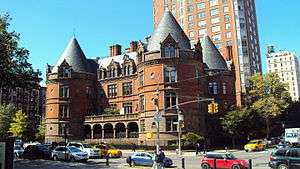
Landmarks
- Frederick Douglass Circle, Central Park West and West 110th Street
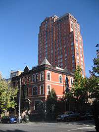
- The former East River Savings Bank, which became the Aspirineum, housing a pharmacy, Amsterdam Avenue and West 96th Street[26]
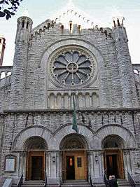
- Church of the Ascension, West 107th Street between Broadway and Amsterdam Avenue
- Straus Park, Broadway and West 106th Street
Notable residents
Barack Obama rented an apartment at 142 West 109th Street, between Columbus Avenue and Amsterdam Avenue.[27][28]
Notes
- ↑ As the farm was acquired prior to the introduction of the Commissioners' Plan of 1811, the boundaries of the farm did not line up precisely with the modern streets set up in the grid plan.
References
- 1 2 Zanoni, Carla (March 25, 2005). "Reactions Mixed as Businesses Close Along Broadway". Columbia Daily Spectator. Archived from the original on October 16, 2015. Retrieved 2010-07-18.
- 1 2 3 "About the Neighborhood: Neighborhood History". Columbus Amsterdam Business Improvement District. Archived from the original on October 16, 2015. Retrieved 2010-10-02.
- 1 2 3 "Manhattan Valley: What you might not know about the Upper West Side's neighbor to the north". BrickUnderground. 2013-07-23. Retrieved 2015-10-16.
- 1 2 Google (October 16, 2015). "Manhattan Valley" (Map). Google Maps. Google. Retrieved October 16, 2015.
- ↑ "Riverside-West 105th Street Historic District Designation Report" (PDF). New York City Landmarks Preservation Commission. April 19, 1973. Archived from the original on October 16, 2015. Retrieved October 16, 2015.
- ↑ Map adapted from Mott, Hopper Striker (1908). New York of Yesterday; A Descriptive Narrative of Old Bloomingdale. Harsenville District, New York City: G. P. Putnam's Sons via Rootsweb.ancestry.com. Archived from the original on October 16, 2015. Retrieved July 19, 2014. Reprinted by Forgotten Books, 2015; ISBN 978-1332169450.
- ↑ Peter Salwen (1989). Upper West Side Story: A History and Guide. Peter Salwen. p. 19. ISBN 978-0-89659-894-2.
- ↑ Albrecht, Leslie (May 1, 2012). "From Bloomingdale to SoHa: One UWS Neighborhood's Quest for a Name". DNAinfo New York. Retrieved October 16, 2015.
- ↑ "West Side Lots At Auction for $9.50 In Clendening Estate Sale in 1845". The New York Times. December 3, 1911. Archived from the original on October 16, 2015. Retrieved October 16, 2015. (subscription required)
- ↑ Susi, M.V. (2009). The Upper West Side. Postcard history series. Arcadia Pub. p. 93. ISBN 978-0-7385-6316-9. Retrieved October 17, 2015.
- 1 2 "John Clendening, Esquire, and his Bloomingdale Estate". bloomingdale history. October 9, 2015. Retrieved October 17, 2015.
- 1 2 3 4 "Manhattan Avenue Historic District Designation Report" (PDF). May 15, 2007. New York City Landmarks Preservation Commission. Retrieved October 16, 2015.
- ↑ Kemp, Emory (1992). "The Engineering Design and Hydraulic Concepts for the Croton Aqueduct". In Kroessler, Jeffrey. The Old Croton Aqueduct: Rural Resources Meet Urban Needs. The Hudson River Museum of Westchester. p. 32. ISBN 978-0943651255.
- ↑ Mann, Maurice (March 23, 2005). "Get Ahead of the Crowd in Manhattan Valley". Real Estate Weekly. Retrieved July 18, 2010.
- ↑ Barbanel, Josh (September 17, 2006). "Would an Aardvark Live Here?". The New York Times. Retrieved July 18, 2010.
- 1 2 Berger, Joseph (September 11, 1987). "HISPANIC LIFE DIMS IN MANHATTAN VALLEY". The New York Times. Retrieved October 17, 2015.
- 1 2 3 4 "Manhattan Valley: A Community Vision for the Future" (PDF). Pratt Institute Graduate Department of City & Regional Planning. May 18, 2010. Retrieved October 16, 2015.
- ↑ "PLAN BOARD BACKS DOUGLASS HOUSES; Huge Manhattantown Project Opposed by Area Residents as Too Costly for Them". The New York Times. February 7, 1952. Retrieved October 17, 2015. (subscription required)
- ↑ Steele, Lockhart (April 3, 2006). "Manhattan Valley, Insane or Not?". NY.Curbed.com. Archived from the original on October 16, 2015. Retrieved October 16, 2015.
- ↑ "History". Manhattan Valley Development Corporation. Archived from the original on October 8, 2007. Retrieved October 16, 2015.
- 1 2 3 4 5 6 7 Nieves, Evelyn (December 25, 1990). "Manhattan Valley's Long Awaited Boom Ends Up Just a Fizzle". The New York Times. Retrieved July 18, 2010.
- 1 2 Haller, Vera (January 26, 2006). "City Living: Manhattan Valley". AM New York. Archived from the original on May 26, 2008.
- ↑ http://columbusamsterdambid.org/about-us/
- ↑ Robledo, S.Jhoanna (February 21, 2005). "Valley of the Deals". New York. Archived from the original on July 1, 2015. Retrieved July 18, 2010.
- ↑ "Demographic/Catchment Area". Manhattan Valley Development Corporation. Archived from the original on January 6, 2009.
- ↑ Hughes, C.J. (2005-02-06). "From the Outside, They Still Look Like Banks". The New York Times. Retrieved 2015-10-17.
- ↑ Remnick, David (2010). The Bridge: The Life and Rise of Barack Obama. New York: Alfred A. Knopf. p. 113. ISBN 978-1-4000-4360-6.
- ↑ Smith, Elizabeth A. (June 7, 2010). "Bragging Rights: President Obama Studied Here". The New York Times. Retrieved 2010-07-18.
Coordinates: 40°47′57.67″N 73°57′46.51″W / 40.7993528°N 73.9629194°W