Maplewood, West Virginia
| Maplewood, West Virginia | |
|---|---|
| Unincorporated community | |
 Maplewood  Maplewood | |
| Coordinates: 37°55′35″N 80°55′59″W / 37.92639°N 80.93306°WCoordinates: 37°55′35″N 80°55′59″W / 37.92639°N 80.93306°W | |
| Country | United States |
| State | West Virginia |
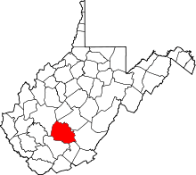
| County | Fayette |
| Elevation | 2,720 ft (830 m) |
| Time zone | Eastern (EST) (UTC-5) |
| • Summer (DST) | EDT (UTC-4) |
| Area code(s) | 304 & 681 |
| GNIS feature ID | 1542742[1] |
Maplewood is an unincorporated community in Fayette County, West Virginia, United States. Maplewood is located on West Virginia Route 41 6.5 miles (10.5 km) northwest of Meadow Bridge.
The community was named for a sugar maple tree at the original town site.[2]
References
- ↑ "US Board on Geographic Names". United States Geological Survey. 2007-10-25. Retrieved 2008-01-31.
- ↑ Kenny, Hamill (1945). West Virginia Place Names: Their Origin and Meaning, Including the Nomenclature of the Streams and Mountains. Piedmont, WV: The Place Name Press. p. 402.
This article is issued from Wikipedia - version of the 10/25/2016. The text is available under the Creative Commons Attribution/Share Alike but additional terms may apply for the media files.