Belva, West Virginia
| Belva | |
|---|---|
| Census-designated place | |
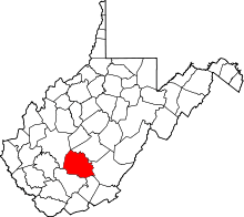
 Belva  Belva Location within the state of West Virginia | |
| Coordinates: 38°13′50″N 81°11′37″W / 38.23056°N 81.19361°WCoordinates: 38°13′50″N 81°11′37″W / 38.23056°N 81.19361°W | |
| Country | United States |
| State | West Virginia |
| Counties | Nicholas and Fayette |
| Area[1] | |
| • Total | 0.162 sq mi (0.42 km2) |
| • Land | 0.137 sq mi (0.35 km2) |
| • Water | 0.025 sq mi (0.06 km2) |
| Population (2010)[2] | |
| • Total | 95 |
| • Density | 590/sq mi (230/km2) |
| Time zone | Eastern (EST) (UTC-5) |
| • Summer (DST) | EDT (UTC-4) |
| GNIS feature ID | 1535619[3] |
Belva is an unincorporated community and census-designated place in west Nicholas County and north Fayette County, West Virginia, United States; while the CDP only includes the Nicholas County portion, the Fayette County portion is considered part of the community.[3][4][5] The town is situated at the bottomland surrounding the convergence of Bells Creek with Twentymile Creek and, subsequently, Twenty Mile Creek with the Gauley River. Belva is also the location of the convergence of two state highways: West Virginia Route 16 and West Virginia Route 39.
History
The community is named in honor of Belva Ann Lockwood, a presidential candidate and early feminist.[6]
Belva post office was established in 1885.[7]
Climate
The climate in this area is characterized by hot, humid summers and generally mild to cool winters. According to the Köppen Climate Classification system, Belva has a humid subtropical climate, abbreviated "Cfa" on climate maps.[8]
See also
- Lockwood, West Virginia, another community in Nicholas County named for Lockwood.
References
- ↑ "US Gazetteer files: 2010, 2000, and 1990". United States Census Bureau. 2011-02-12. Retrieved 2011-04-23.
- ↑ "American FactFinder". United States Census Bureau. Archived from the original on 2013-09-11. Retrieved 2011-05-14.
- 1 2 "Belva". Geographic Names Information System. United States Geological Survey.
- ↑ "Belva Census Designated Place". Geographic Names Information System. United States Geological Survey.
- ↑ Fayette County, West Virginia General Highway Map (PDF) (Map). West Virginia Department of Transportation. 2011. § 1. Retrieved 2011-06-24.
- ↑ Kenny, Hamill (1945). West Virginia Place Names: Their Origin and Meaning, Including the Nomenclature of the Streams and Mountains. Piedmont, WV: The Place Name Press. p. 105.
- ↑ Helbock, Richard W. (2004) United States Post Offices, Volume VI - The Mid-Atlantic, p. 33 Scappoose, Oregon: La Posta Publications
- ↑ Climate Summary for Belva, West Virginia
Municipalities and communities of Nicholas County, West Virginia, United States | ||
|---|---|---|
| City | 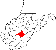 | |
| CDPs | ||
| Unincorporated communities |
| |
| Ghost towns | ||
| Footnotes | ‡This populated place also has portions in an adjacent county or counties | |