Marrowbone, Cumberland County, Kentucky
| Marrowbone, Kentucky | |
|---|---|
| Census-designated place | |
 Marrowbone  Marrowbone Location within the state of Kentucky | |
| Coordinates: 36°49′39″N 85°30′24″W / 36.82750°N 85.50667°WCoordinates: 36°49′39″N 85°30′24″W / 36.82750°N 85.50667°W | |
| Country | United States |
| State | Kentucky |
| County | Cumberland |
| Area | |
| • Total | 1.29 sq mi (3.34 km2) |
| • Land | 1.27 sq mi (3.30 km2) |
| • Water | 0.02 sq mi (0.04 km2) |
| Elevation | 643 ft (196 m) |
| Population (2010) | |
| • Total | 217 |
| • Density | 170/sq mi (65.7/km2) |
| Time zone | Central (CST) (UTC-6) |
| • Summer (DST) | CDT (UTC-5) |
| ZIP codes | 42759 |
| FIPS code | 21-50124 |
| GNIS feature ID | 497558 |
Marrowbone is a census-designated place and unincorporated community in Cumberland County, Kentucky, United States. As of the 2010 census it had a population of 217.[1] It has a post office, with the ZIP code of 42759.[2]
Geography
It lies along Route 90 west of the city of Burkesville, the county seat of Cumberland County.[3] Its elevation is 643 feet (196 m), and it is located at about (36.8288889, -85.5030556).[4]
History
In March 2010, nine congregants of the Marrowbone Christian Brotherhood Mennonite Church were among eleven killed on Interstate 65 near Bowling Green and Mammoth Cave National Park in Kentucky's deadliest vehicle wreck in 20 years.
References
- ↑ "Geographic Identifiers: 2010 Demographic Profile Data (G001): Marrowbone CDP, Kentucky". U.S. Census Bureau, American Factfinder. Retrieved August 13, 2014.
- ↑ Zip Code Lookup
- ↑ Rand McNally. The Road Atlas '06. Chicago: Rand McNally, 2006, p. 42.
- ↑ U.S. Geological Survey Geographic Names Information System: Marrowbone, Cumberland County, Kentucky, Geographic Names Information System, 1979-09-20. Accessed 2007-12-31.
Municipalities and communities of Cumberland County, Kentucky, United States | ||
|---|---|---|
| City | 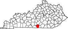 | |
| CDP | ||
| Other unincorporated communities | ||
This article is issued from Wikipedia - version of the 7/27/2016. The text is available under the Creative Commons Attribution/Share Alike but additional terms may apply for the media files.