Bowling Green, Kentucky
| Bowling Green, Kentucky | |
|---|---|
| City | |
|
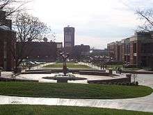
Shops along Fountain Square in downtown Bowling Green | |
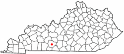 Location of Bowling Green within Warren County in Kentucky. | |
 Bowling Green, Kentucky Location in the United States | |
| Coordinates: 36°58′54″N 86°26′40″W / 36.98167°N 86.44444°WCoordinates: 36°58′54″N 86°26′40″W / 36.98167°N 86.44444°W | |
| Country | United States |
| State | Kentucky |
| County | Warren |
| Government | |
| • Mayor | Bruce Wilkerson |
| Area | |
| • City | 35.6 sq mi (92.1 km2) |
| • Land | 35.4 sq mi (91.7 km2) |
| • Water | 0.2 sq mi (0.4 km2) |
| Elevation | 547 ft (166.7 m) |
| Population (2015) | |
| • City | 63,616 |
| • Density | 1,536.9/sq mi (537.5/km2) |
| • Metro | 165,732 |
| Time zone | CST (UTC−6) |
| • Summer (DST) | CDT (UTC−5) |
| ZIP codes | 42101-42104 |
| Area code(s) | 270 & 364 |
| FIPS code | 21-08902 |
| GNIS feature ID | 0487744 |
| Website |
www |

Bowling Green is a city in and the county seat of Warren County, Kentucky, United States.[1] As of 2015, its population of 63,616 made it the third most-populous city in the state after Louisville and Lexington; its metropolitan area had an estimated population of 165,732; and the combined statistical area it shares with Glasgow has an estimated population of 218,870.[2][3][4]
Founded by pioneers in 1798, Bowling Green was the provisional capital of Confederate Kentucky during the American Civil War. The city was the inspiration for the 1967 Everly Brothers song "Bowling Green". It is the home of numerous manufacturers, including General Motors and Fruit of the Loom. The Bowling Green Assembly Plant has been the source of all Chevrolet Corvettes built since 1981. Bowling Green is also home to the state's second-largest public university, Western Kentucky University. In 2014, Forbes magazine listed Bowling Green as one of the Top 25 Best Places to Retire in the United States.[5]
History
Settlement and incorporation
The first Europeans known to have reached the area carved their names on beech trees near the river around 1775. By 1778, settlers established McFadden's Station on the north bank of the Barren River.[6]
Present-day Bowling Green grew out of homesteads erected by Robert[6] and George Moore and General Elijah Covington, the namesake of the town near Cincinnati. The Moore brothers arrived from Virginia circa 1794. In 1798, only two years after Warren County had been formed, Robert Moore donated 2 acres (8,100 m2) of land to county trustees for the purpose of constructing public buildings. Soon after, he donated an additional 30 to 40 acres (120,000 to 160,000 m2) surrounding the original plot. The city of Bowling Green was officially incorporated by the Commonwealth of Kentucky on March 6, 1798.
Some controversy exists over the source of the town's name. The city itself follows the first county commissioners' meeting (1798), which named the town "Bolin Green" after the Bowling Green in New York City where patriots had pulled down a statue of King George III and used the lead to make bullets during the American Revolution.[6] Some historians dispute this, however, and credit Bowling Green, Virginia, or a personal "ball alley game" of Robert Moore's instead.[7] Early records indicate that the city name was also spelled "Bowlingreen".
Nineteenth century
By 1810, Bowling Green had 154 residents. Growth in steamboat commerce and the proximity of the Barren River increased Bowling Green's importance. Canal locks and dams on the Barren River made it much more navigable. In 1832, the first portage railway connected the river to the location of the current county courthouse. Mules pulled freight and passengers to and from the city on the tracks.
Despite rapid urbanization of the Bowling Green area in the 1830s, agriculture remained an important part of local life. A visitor to Bowling Green noted the boasting of a tavern proprietor named Benjamin Vance:
| “ | [Vance] says that he has seen a turnip this fall that measures thirty-two inches around, and has a beet that weighs sixteen pounds and a half;... that corn in this country grows so fast that if you look at it the next, it has grown a foot higher; that the "little hickory twigs" growing in the barrens have roots as large as his legs... | ” |
In 1859, the Louisville and Nashville Railroad (currently CSX Transportation) laid railroad through Bowling Green that connected the city with northern and southern markets.
Bowling Green declared itself neutral in an attempt to escape the Civil War. Because of its prime location and resources, however, both the Union and Confederacy sought control of the city. The majority of its residents rejected both the Confederacy and the Lincoln administration. On September 18, 1861, around 1300 Confederate soldiers arrived from Tennessee to occupy the city, placed under command of Kentucky native General Simon Bolivar Buckner. The city's pro-Union feelings surprised the Confederate occupiers.[8] Surrounding hills were fortified to secure possible military approaches to the valuable river and railroad assets. In November 1861, the provisional Confederate government of Kentucky chose Bowling Green as its capital.[9]
On February 14, 1862, after receiving reports that Fort Henry on the Tennessee River and Fort Donelson on the Cumberland River had both been captured by Union forces under Ulysses S. Grant, the Confederates realized they had to withdraw from Bowling Green. They destroyed bridges across the Barren River, the railroad depot, and other important buildings that could be used by the enemy. The city was subject to disruptions and raids throughout the remainder of the war. During the summer of 1864, Union General Stephen G. Burbridge arrested 22 civilians in and around Bowling Green on a charge of treason. This incident and other harsh treatment by federal authorities led to bitterness towards the Union among Bowling Green residents and increased sympathies with the Confederacy.
After the Civil War, Bowling Green's business district grew considerably. Previously, agriculture had dominated the city's economy. During the 1870s, many of the historic business structures seen today were erected. One of the most important businesses in Bowling Green of this era was Carie Burnam Taylor's dress-making company. By 1906, Taylor employed more than 200 women.
In 1868, the city constructed its first waterworks system. The fourth county courthouse was completed in 1868. The first three were completed in 1798, 1805, and 1813. In 1889, the first mule-drawn street cars appeared in the city. The first electric street cars began to replace them by 1895.
The Sisters of Charity of Nazareth founded St. Columbia's Academy in 1862, succeeded by St. Joseph's School in 1911.[10] In 1884, the Southern Normal School, which had been founded in 1875, moved to Bowling Green from the town of Glasgow, Kentucky. Pleasant J. Potter founded a women's college in Bowling Green in 1889. It closed in 1909 and its property sold to the Western Kentucky State Normal School (see below, now known as Western Kentucky University). Other important schools in this era were Methodist Warren College, Ogden College (which also became a part of Western Kentucky University), and Green River Female College, a boarding school.
Twentieth century
In 1906, Henry Hardin Cherry, the president and owner of Southern Normal School, donated the school to the state as the basis of the Western State Normal School. The school trained teachers for the expanding educational needs of the state. This institution is now known as Western Kentucky University and is the second-largest public university in the state, having recently grown larger than the University of Louisville.
In 1906, Doctors Lillian H. South, J. N. McCormack, and A.T. McCormack opened St. Joseph Hospital to provide around-the-clock medical and nursing care to the residents and students in the area.[11][12]
In 1925, the Kentucky Street Rail Depot was opened. About 27 trains arrived daily at the depot. Local bus lines were also a popular form of travel. By the 1950s, both of these forms of transportation had dramatically declined as highway construction was subsidized by the federal government and the private car became the primary means of travel.
In 1940, a Union Underwear factory built in Bowling Green bolstered the city's economy significantly. During the 1960s, the city's population began to surpass that of Ashland, Paducah, and Newport.
Downtown streets became a bottleneck for traffic. In 1949, the U.S. Route 31W Bypass was opened to alleviate traffic problems, but it also drew off business from downtown. The bypass grew to become a business hotspot in Bowling Green. A 1954 advertisement exclaimed, "Your business can grow in the direction Bowling Green is growing -- to the 31-W By-Pass".
By the 1960s, the face of shopping was changing completely from the downtown square to suburban shopping centers. Between May and November 1967, stores in Bowling Green Mall opened for business. Another advertisement said, "One-stop shopping. Just park [free], step out and shop. You'll find everything close at hand." Between September 1979 and September 1980, stores in the larger Greenwood Mall came on line. The city's limits began to stretch toward Interstate 65.
By the late 1960s, Interstate 65, which runs just to the east of Bowling Green, was completed. The Green River Parkway (now called the William H. Natcher Parkway), was completed in the 1970s to connect Bowling Green and Owensboro. These vital transportation arteries attracted many industries to Bowling Green.
In 1981, General Motors moved its Chevrolet Corvette assembly plant from St. Louis, Missouri, to Bowling Green. In the same year, the National Corvette Homecoming event was created, becoming a large gathering of Corvette owners, car parades, and related activities in Bowling Green each year. In 1994, the National Corvette Museum was constructed near the assembly plant.
In 1997, Bowling Green was designated a Tree City USA by the National Arbor Day Foundation.
Twenty-first century initiatives
In 2012, the city undertook a feasibility study on ways to revitalize the downtown Bowling Green area. The Downtown Redevelopment Authority was formed to plan redevelopment. Plans for the project incorporated Bowling Green's waterfront assets and historic center and streetscape around Fountain Square. It also proposed a new building for the Bowling Green Area Chamber of Commerce, construction of a Riverwalk Park where downtown borders the Barren River, creation of a new public park called Circus Square, and installation of a new retail area, the Fountain Square Market.[13]
As of spring 2009, the new Chamber of Commerce, Riverwalk Park, and Circus Square have been completed. The Southern Kentucky Performing Arts Center, a facility for arts and education, broke ground in October 2009 and celebrated its opening night on March 10, 2012, with a concert by Vince Gill.[14] Ground was broken for the Fountain Square Market in 2012.
In 2005, an effort was made to incorporate a Whitewater Park into the downtown Bowling Green riverfront at Weldon Peete Park. Due to the recession, the project was not funded. In 2011, the project evolved into the Bowling Green Riverfront Foundation, expanding its efforts to develop land on the opposite side of Barren River from Mitch McConnell Park (which is located alongside the U.S. 31-W Bypass and the riverbank, between Louisville Road and Old Louisville Road), all the way upriver to Peete Park. The new plans include use of the adjacent river for white-water sports — the stretch of river includes rapids rated on the International Scale of River Difficulty between Class II and Class IV — as well as a mountain biking trail, a bicycle pump track, and a rock climbing area.[15] Some of this facility will be located on a reclaimed landfill which had served as Bowling Green's garbage dump for many years.
Geography
The Bowling Green-Warren County Regional Airport is 547 feet (167 m) above sea level. According to the United States Census Bureau, the city has a total area of 35.6 square miles (92 km2), of which 35.4 square miles (92 km2) is land and 0.2 square miles (0.52 km2) (0.45%) is covered by water.
Climate
Bowling Green has a humid subtropical climate (Köppen climate classification Cfa). The monthly daily average temperature ranges from 35.7 °F (2.1 °C) in January to 78.7 °F (25.9 °C) in July. On average, 41 days of 90 °F (32 °C)+ highs occur annually, and 11 days occur each winter when the high fails to rise above freezing. Annual precipitation is 49.3 inches (1,250 mm), with the late spring and summer being slightly wetter; snowfall averages 8.4 inches (21.3 cm) per year. Extreme temperatures range from −21 °F (−29 °C) on January 23 and 24, 1963, up to 108 °F (42 °C) on July 28, 1930.
| Climate data for Bowling Green, Kentucky (Warren County Airport), 1981–2010 normals | |||||||||||||
|---|---|---|---|---|---|---|---|---|---|---|---|---|---|
| Month | Jan | Feb | Mar | Apr | May | Jun | Jul | Aug | Sep | Oct | Nov | Dec | Year |
| Record high °F (°C) | 78 (26) |
82 (28) |
92 (33) |
96 (36) |
100 (38) |
110 (43) |
113 (45) |
110 (43) |
105 (41) |
94 (34) |
88 (31) |
78 (26) |
113 (45) |
| Average high °F (°C) | 45.0 (7.2) |
50.0 (10) |
59.8 (15.4) |
69.7 (20.9) |
77.8 (25.4) |
86.1 (30.1) |
89.4 (31.9) |
88.9 (31.6) |
82.1 (27.8) |
71.2 (21.8) |
59.4 (15.2) |
47.9 (8.8) |
68.9 (20.5) |
| Average low °F (°C) | 26.4 (−3.1) |
29.6 (−1.3) |
37.0 (2.8) |
45.6 (7.6) |
55.0 (12.8) |
63.9 (17.7) |
67.9 (19.9) |
66.1 (18.9) |
58.0 (14.4) |
46.3 (7.9) |
37.5 (3.1) |
29.2 (−1.6) |
46.9 (8.3) |
| Record low °F (°C) | −21 (−29) |
−20 (−29) |
−6 (−21) |
19 (−7) |
30 (−1) |
39 (4) |
46 (8) |
42 (6) |
33 (1) |
19 (−7) |
−7 (−22) |
−14 (−26) |
−21 (−29) |
| Average precipitation inches (mm) | 3.58 (90.9) |
4.00 (101.6) |
3.88 (98.6) |
4.33 (110) |
5.67 (144) |
4.09 (103.9) |
4.17 (105.9) |
3.38 (85.9) |
3.80 (96.5) |
3.44 (87.4) |
4.18 (106.2) |
4.80 (121.9) |
49.33 (1,253) |
| Average snowfall inches (cm) | 2.5 (6.4) |
3.4 (8.6) |
1.1 (2.8) |
0.1 (0.3) |
0 (0) |
0 (0) |
0 (0) |
0 (0) |
0 (0) |
0 (0) |
0 (0) |
1.3 (3.3) |
8.4 (21.4) |
| Average precipitation days (≥ 0.01 in) | 10.4 | 10.5 | 11.4 | 11.7 | 11.8 | 10.6 | 10.0 | 7.9 | 7.9 | 8.5 | 9.9 | 11.5 | 121.9 |
| Average snowy days (≥ 0.1 in) | 2.1 | 2.3 | 0.7 | 0.1 | 0 | 0 | 0 | 0 | 0 | 0 | 0 | 1.3 | 6.5 |
| Source: NOAA (extremes 1893–present)[16] | |||||||||||||
Demographics
| Historical population | |||
|---|---|---|---|
| Census | Pop. | %± | |
| 1800 | 41 | — | |
| 1810 | 154 | 275.6% | |
| 1830 | 821 | — | |
| 1870 | 4,574 | — | |
| 1880 | 5,114 | 11.8% | |
| 1890 | 7,803 | 52.6% | |
| 1900 | 8,226 | 5.4% | |
| 1910 | 9,173 | 11.5% | |
| 1920 | 9,638 | 5.1% | |
| 1930 | 12,348 | 28.1% | |
| 1940 | 14,585 | 18.1% | |
| 1950 | 18,347 | 25.8% | |
| 1960 | 28,338 | 54.5% | |
| 1970 | 36,705 | 29.5% | |
| 1980 | 40,450 | 10.2% | |
| 1990 | 40,641 | 0.5% | |
| 2000 | 49,296 | 21.3% | |
| 2010 | 58,067 | 17.8% | |
| Est. 2015 | 63,616 | [17] | 9.6% |
As of the census[19] of 2010, 58,067 people and 22,735 households resided in the city. The population density was 1631.1 people per square mile (630.5/km²). The racial makeup of the city was 75.8% White, 13.9% African American, 0.3% Native American, 4.2% Asian, 0.2% Pacific Islander, 2.16% from other races, and 2.7% from two or more races. Hispanics or Latinos of any race were 6.5% of the population.
Of the 22,735 households, 24.6% had children under the age of 18 living with them, 33.1% were married couples living together, 14.1% had a female householder with no husband present, and 48.3% were not families. About 35.4% of all households were made up of individuals, and 19.7% had someone living alone who was 65 years of age or older. The average household size was 2.28, and the average family size was 2.99.
The age distribution was 20.1% under 18, 28% from 15 to 24, 25.6% from 25 to 44, 18.8% from 45 to 64, and 10.6% who were 65 or older. The median age was 27.6 years. Females made up 51.7% of the population and males made up 48.3%.
The median income for a household in the city was $33,362, and for families was $45,287. Males had a median income of $35,000 versus $28,916 for females. The per capita income for the city was $19,302. About 19.4% of families and 27.7% of the population were below the poverty line, including 30.9% of those under age 18.
Economy
Bowling Green is shifting to a more knowledge-based, technology-driven economy. With one major public university and a technical college, Bowling Green serves as an education hub for the south-central Kentucky region. In addition, the city is the region's leading medical and commercial center.
General Motors Manufacturing Plant, Holley Performance Products, Houchens Industries, SCA, Camping World, Minit Mart, Fruit of the Loom, Russell Brands, and other major industries call Bowling Green home. It has also attracted new industries, such as Bowling Green Metalforming, a division of Magna International, Inc., and Halton Company, which chose to expand their worldwide companies into Bowling Green.
Commonwealth Health Corporation, Western Kentucky University, and Warren County Board of Education are the biggest employers for Bowling Green and the surrounding region. Other companies based in Bowling Green include Eagle Industries and Trace Die Cast. The third-largest home shopping network, EVINE Live, has its warehouse fulfillment center located off Nashville Road. EVINE Live also recently moved a large amount of its customer service call center operations to its Bowling Green location. EVINE Live's corporate headquarters are located in Eden Prairie, Minnesota, although the largest part of its day-to-day operations are in Bowling Green.
Compared with Elizabethtown and Owensboro MSAs, Bowling Green has experienced the largest post-recession employment gain. From November 2001 to April 2006, total payroll employment increased by 13%. Bowling Green has experienced a 5% increase in manufacturing employment, a 5% increase in professional and business services, and a 6% increase in leisure and hospitality since April 2005.
Bowling Green's high income and job growth combined with a low cost of doing business led the city to be named to Forbes magazine's 2009 list of the "Best Small Places for Business". In an evaluation of 179 cities across the nation, Forbes ranked Bowling Green 19th best city in which to do business, finishing ahead of Elizabethtown and Owensboro. The list ranked Bowling Green 34th nationwide for the lowest cost-of-living and 22nd for highest job growth.
In March 2009, the Bowling Green metropolitan area was recognized by Site Selection magazine as a top economic development community in the United States for communities with populations between 50,000 and 200,000 people. The Bowling Green metro also received the same recognition by Site Selection in 2008.
The Bowling Green Area Chamber of Commerce received the 2009 Chamber of the Year by the American Chamber of Commerce Executives and a 5-Star Chamber by the U.S. Chamber of Commerce.
Top employers
According to the city's 2011 Comprehensive Annual Financial Report,[20] the top employers include three public-sector employers:
| # | Employer | # of Employees |
|---|---|---|
| 1 | Western Kentucky University | 4,626 |
| 2 | The Medical Center at Bowling Green | 1,914 |
| 3 | Fruit of the Loom | 1,632 |
| 4 | Walmart | 1,018 |
| 5 | Warren County Public Schools | 958 |
| 6 | Express Employment Professionals | 931 |
| 7 | Sun Products | 917 |
| 8 | Houchens Industries | 733 |
| 9 | Magna International | 665 |
| 10 | City of Bowling Green | 633 |
Education
Primary and secondary education
Public education is provided by the Warren County Public Schools system and the Bowling Green Independent School District. Several private schools also serve Bowling Green students.
Religious schools
- Anchored Christian School – Preschool through 12th grade Baptist Christian school[21]
- Bowling Green Christian Academy – Preschool through 12th grade non-denominational Christian school
- Foundation Christian Academy – Preschool through 8th grade Church of Christ Christian school[22]
- Holy Trinity Lutheran – Preschool through 6th grade Lutheran Christian school[23]
- Old Union School – Preschool through 12th grade Christian school[24]
- Saint Joseph – Preschool through 8th grade Catholic school
.jpg)
Elementary schools
Warren County Public Schools
- Alvaton Elementary
- Briarwood Elementary
- Bristow Elementary
- Cumberland Trace Elementary
- Drakes Creek Middle School
- Greenwood High School
- Henry Moss Middle School
- Lost River Elementary
- North Warren Elementary
- Oakland Elementary
- Plano Elementary
- Rich Pond Elementary
- Jody Richards Elementary
- Richardsville Elementary
- Rockfield Elementary
- South Warren High School
- South Warren Middle School
- Warren Elementary
- Warren Central High School
- Warren East High School
- Warren East Middle School
- William H. Natcher Elementary School
Bowling Green Independent School District
- Dishman-McGinnis
- Parker Bennett Curry
- Potter Gray
- T.C. Cherry
- W.R. McNeill
Middle and junior high schools
All of these schools are operated by the Warren County district except Bowling Green Junior High.
- Bowling Green Junior High
- Drakes Creek Middle School
- Henry F. Moss Middle School
- Warren East Middle School
- South Warren Middle School
High schools
All schools are operated by the Warren County district except Bowling Green High and Carol Martin Gatton Academy of Mathematics and Science.
- Bowling Green High
- Carol Martin Gatton Academy of Mathematics and Science in Kentucky
- Greenwood High
- Warren Central High
- Warren East High
- South Warren High School
- Lighthouse Academy High School
Postsecondary education
- Bowling Green Adult Learning Center
- Daymar College
- Southcentral Kentucky Community and Technical College
- Western Kentucky University
Public library
The Warren County Public Library has four permanent locations. The Main Library, which opened in 1956, is in downtown Bowling Green. The Smiths Grove Branch, the system's first branch location, is located in the nearby community of Smiths Grove, Kentucky. The Graham Drive Community Library is a neighborhood branch located in a residential area of the Housing Authority of Bowling Green; it opened in late 2007 and replaced the branch formerly located in the Sugar Maple Square Shopping Center. The system's newest location is the Bob Kirby Branch Library, located off Interstate 65 close to Greenwood High School, which opened spring 2008. The Mobile Branch is a 28-foot (8.5 m) truck that travels across Bowling Green and Warren County carrying a variety of library materials for adults and children. The Depot Branch, which opened in 2001, was located in the historic, renovated Louisville and Nashville Railroad Depot and housed a technology and early childhood center, as well as traditional library materials; it closed in late 2007. On July 27, 2007, the Warren County Fiscal Court voted to create a county-wide taxing district to benefit the public library. The library system, formerly known as the Bowling Green Public Library, became the Warren County Public Library on July 1, 2008.
Transportation
Major highways
-
 Interstate 65 north to Louisville, south to Nashville, Tennessee
 - William H. Natcher Parkway north to Owensboro, Kentucky
-
 U.S. Route 231 north to Morgantown, south to Scottsville, Kentucky
 -
 U.S. Route 31W north to Park City, south to Franklin, Kentucky
 -

 U.S. Route 68 / Kentucky State Route 80 west to Hopkinsville, Kentucky, east to Lexington, Kentucky
Other highways
Air transport
Starting August 29, 2016 the Bowling Green–Warren County Regional Airport will provide non-stop commercial airline service to Hartsfield-Jackson Atlanta International Airport on a daily basis. Seasonal flights to Destin-Fort Walton Beach Airport will also be provided both via Contour Airlines.
Buses
Community Action of Southern Kentucky operates GO bg Transit, which provides public transportation to Bowling Green. Intercity carriers that serve Bowling Green include Greyhound and Tornado Bus Company.
Attractions
Parks and recreation
The Bowling Green Parks and Recreation Department administers 895 acres (3.62 km2) of public land for recreational use.
Community centers
- F. O. Moxley – Facility includes a game room (billiards, video games), board game room, concession stand, racquetball/wallyball courts and basketball courts.
- Parker-Bennett – Facility has hourly rental rates for meetings, parties and receptions.
- Kummer/Little Recreation Center – Facility includes basketball/volleyball courts, concession stand, and walking trails.
- Delafield Community Center – Facility includes an auditorium, basketball courts, a playground, and picnic shelters.
Parks
- See Parks in Bowling Green, Kentucky for a formatted table of this data.
- Aviation Heritage Park – located at the corner of Three Springs Road and Smallhouse Road. The park is an ongoing project. It is designed and constructed to include a landscaped area that accommodates up to a total of seven planes.[25]
- 'Basil Griffin – Named for former Warren County Judge- Large pond with migratory birds such as ducks and geese, playground, disc golf, picnic tables/pavilions, soccer fields, volleyball court.
- C. W. Lampkin – Baseball fields, outdoor basketball courts, concession stands, grills, picnic pavilions and tables, playgrounds, soccer field, tennis courts, volleyball courts
- Chuck Crume Nature – picnic tables, walking/running trail
- Covington Woods – golf course, baseball field, outdoor basketball court, concession stand, grills, picnic pavilions and tables, playgrounds, tennis courts, volleyball court
- Fort Webb – historic site
- Fountain Square – historic Victorian fountain and city square in Downtown Bowling Green

- H. P. Thomas – barbecue grills, picnic tables, playground, soccer fields, volleyball court
- Hobson Grove – golf course, baseball fields, disc golf course, historic site, picnic tables, concession stands
- James Hines – boating, historic site
- Lovers Lane – soccer fields, disc golf course, picnic pavilion & tables, playgrounds, concession stand
- Ogden – playground
- Pedigo – baseball fields, outdoor basketball court, batting cage, concession stand, picnic pavilion & tables, playground, volleyball court
- Preston Miller – water park/swimming pool, disc golf course, picnic pavilions & tables, playgrounds, swimming pools, volleyball courts, walking/running/running trail, concession stand
- Reservoir Hill – grills, historic site, picnic pavilion & tables, playground
- RiverWalk/Brownfield – historic site, walking/running trail
- Roland Bland – skatepark, outdoor basketball courts, grills, horseshoes, picnic pavilion & tables, playgrounds, soccer field, tennis courts, volleyball court
- Spero Kereiakes – baseball fields, outdoor basketball court, batting cage, concession stand, disc golf course, grills, picnic pavilions & tables, playgrounds, public gardening plots, soccer fields, tennis courts, volleyball court, walking/running trail
- Westside Neighborhood – outdoor basketball court, playground
Swimming centers
- Russell Sims Aquatic Center – The largest "water playground" in south-central Kentucky. The center includes zero-depth entry into the water, splash playground, swimming pool, water slides, diving boards and concessions.
- Warren County Aquatics Facility – Domed pool facility open year-round. Closed February 2008. New facility is now open on Lover's Lane behind Warren County Public Schools main office. This facility was closed to public in April 2014 and is now used by private and school swim teams and physical therapy.
Museums

- Barren River Imaginative Museum of Science – Unique "hands-on" science museum where visitors can experience the force of a mini-tornado, operate one of the largest interactive transportation exhibits in the country, suspend a body with magic mirrors, and more. Closed SEP 2011
- Kentucky Museum and Library – Home of rich collections and education exhibits on Kentucky history and heritage. Genealogical materials, published works, manuscripts and folk life information.
- National Corvette Museum – Showcase of America's sports car with more than 75 Corvettes on display, including mint classics, one-of-a-kind prototypes, racetrack champions and more.
- Historic Railpark and Train Museum – L & N Depot – Train museum in the original train depot of Bowling Green. Opened after the library moved at the end of 2007. Includes 5 restored historic rail cars.
- Riverview at Hobson Grove – This historic house museum is a classic example of Italianate architecture—arched windows, deep eaves with ornamental brackets, and cupola. Painted ceilings. Began late 1850s, Confederate munitions magazine in winter 1861-62, and completed 1872.
Sports and event venues
E.A. Diddle Arena, located on the campus of Western Kentucky University, is a multi-purpose arena with a seating capacity of 7,500 persons. Built in 1963 and renovated in 2004, the arena has hosted college sports such as basketball and volleyball. It also hosted the KHSAA Girls' Sweet Sixteen state championship event in high school basketball from 2001 to 2015, after which it moved to BB&T Arena at Northern Kentucky University.[26] The arena has also played host to various traveling rodeos and circuses. In 2006, Diddle Arena hosted the first WWE event to be held in Bowling Green in over ten years.

The city and surrounding area is home to the Warren County Inline Hockey League. It also is home to the Western Kentucky University Hilltoppers team, which competes in the NCRHA, and has several members in the Bluegrass Hockey League and Central Commonwealth League.
Bowling Green Ballpark is a new stadium currently in use in Bowling Green. It is primarily used for baseball, for the Single-A Bowling Green Hot Rods organization of the Midwest League. The Hot Rods began play in the spring of 2009 in the South Atlantic League, transferring to the Midwest League for 2010. They are a farm team for Major League Baseball's Tampa Bay Rays.
The Bowling Green Hornets of the Central Basketball League are based in Bowling Green, although they play their home games in Russellville. The Hornets are coached by Russellville native Nathan Thompson.
Golf courses

Bowling Green has six golf and eight disc golf courses.
| Golf | Disc golf |
|---|---|
| Crosswinds | Basil Griffin Park |
| Paul Walker | Hobson Grove Park |
| River View | KOA Kampground |
| Olde Stone | Lovers Lane Park |
| Bowling Green Country Club | Preston Miller Park |
| Indian Hills | Spero Kereiakes Park |
| White Park | |
| William H. Natcher Elementary |
Other attractions

- Bowling Green Ballpark
- General Motors Assembly Plant
- National Corvette Homecoming
- Capitol Arts Center
- Cave Spring Caverns
- Eloise B. Houchens Center
- Historic Railpark at the L&N Depot
- Lost River Cave and Valley
- Riverview at Hobson Grove
- Great American Donut Shop (GADS)
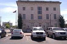
- William H. Natcher Federal Building and United States Courthouse
- Southern Kentucky Performing Arts Center (SkyPac)
- Low Hollow Bike Trail at Weldon Peete Park
- Corsair Artisan Distillery
- Civil War Discovery Trail
- Duncan Hines Scenic Byway
- Shake Rag Historic District
- Warren County Quilt Trail
- St.Joseph Historic District
Media
- Refer to external links for respective media websites.
Print media
- The Amplifier – Southern Kentucky's Arts & Entertainment monthly since 1995
- Bowling Green Daily News
- Bowling Green Parent – A resource for families in the South Central Kentucky area
- Buy Local Bowling Green
- College Heights Herald – WKU student newspaper
- The Sporting Times – South-Central Kentucky's first area high school monthly publication
- Country Peddler
- Soky Happenings – A Guide to What's Happening In and Around Bowling Green KY
Television
- WBKO ABC Channel 13
- WKYU PBS Channel 24
- WCZU Antenna TV/MNTV Channel 39
- WNKY NBC Channel 40
- WKGB PBS/KET Channel 53
- Time Warner Cable/Spectrum (Cable Operator)
Digital broadcast
- WBKO ABC Channel 13.1 720p
- WBKO Fox Channel 13.2 480i
- WBKO CW Channel 13.3 480i
- WCZU Antenna TV/MNTV Channel 39.1 480i
- WCZU DrTV Channel 39.2 480i
- WNKY NBC Channel 40.1 1080i
- WNKY CBS Channel 40.2 480i
- WKYU PBS Channel 24.1 1080i
- WKYU Create Channel 24.2 480i
- WKGB PBS Channel 53.1 KET1 720p
- WKGB PBS Channel 53.2 KET2 480i
- WKGB PBS Channel 53.3 KETKY The Kentucky Channel 480i
Radio
- AM 930 WKCT – News/Talk
- AM 1340 WBGN – The Ticket(Fox Sports Radio)
- AM 1450 WWKU – ESPN Radio
- FM 88.1 WAYFM – WAYFM
- FM 88.9 WKYU – Western Kentucky University Public Radio
- FM 90.7 WCVK – Christian Family Radio
- FM 91.7 WWHR – "Revolution" WKU's student radio station
- FM 93.3 WDNS – Bowling Green's Classic Rock Station
- FM 95.1 WGGC – Goober 95.1 – Country
- FM 96.7 WBVR – The Beaver – Country (licensed to Auburn, Kentucky)
- FM 100.7 WKLX – Sam 100.7 – Classic hits (licensed to Brownsville, Kentucky)
- FM 103.7 WHHT – Howdy 103.7 – Country (licensed to Cave City, Kentucky)
- FM 105.3 WPTQ – The Point – Classic / Active Rock (licensed to Glasgow, Kentucky)
- FM 106.3 WOVO – Wovo106.3 – Adult contemporary (licensed to Horse Cave, Kentucky)
- FM 107.1 WUHU – Woohoo – Top 40 (licensed to Smiths Grove, Kentucky)
Nearby cities and communities
County communities
Nearby communities include: Allen Springs, Alvaton, Blue Level, Browning, Cavehill, Drake, Oakland, Petros, Plano, Plum Springs, Richardsville, Rich Pond, Rockfield, Smiths Grove and Woodburn.
Neighboring cities
| Brownsville | Franklin | Glasgow |
| Morgantown | Russellville | Scottsville |
Notable people
- Thomas Lilbourne Anderson – U.S. Representative from Missouri[27]
- Ben Bailey – comedian and host of TV game show Cash Cab
- Gary Barnidge -Professional football tight end for the Cleveland Browns
- Sam Bush – musician
- Athena Cage – musician
- Cage the Elephant – Rock band
- Chris Carmichael – musician
- John Carpenter – film director
- Rex Chapman – former professional basketball player, played for the Kentucky Wildcats in college, played professionally for the Charlotte Hornets, Washington Bullets, Miami Heat and the Phoenix Suns. Vice president of player personnel with the Denver Nuggets.
- David F. Duncan – epidemiologist and drug policy consultant in the Clinton Administration
- Frances Fowler – painter
- Foxhole – instrumental post-rock group
- Dorothy Grider – artist and illustrator of children's books
- Henry Grider – U.S. Representative
- Brett Guthrie – U.S. Representative
- Mordecai Ham – Christian evangelist and pastor of the Burton Memorial Baptist Church early in the 20th century
- Corey Hart – Milwaukee Brewers right fielder, 2008 and 2010 MLB All Star
- Duncan Hines – food critic and cookbook author
- Hillbilly Jim – professional wrestler
- Ben Keith – American pedal steel guitarist, solo musician and producer
- Paul Kilgus – former professional baseball player
- John D. Minton, Jr. – Chief Justice of the Kentucky Supreme Court
- Doug Moseley – former United Methodist clergyman and former state senator
- Thomas Nicholson – Professor at Western Kentucky University. Authority on drug abuse and drug policy who was on the shortlist of candidates to become President Obama's Director of National Drug Control Policy.
- Rand Paul – ophthalmologist and U.S. Senator; son of U.S. Representative Ron Paul from Texas
- George Boyd Pierce, Republican former member of the Texas House of Representatives from his native San Antonio; former Bowling Green resident
- Deborah Renshaw – NASCAR driver
- Robert Reynolds – former professional football player
- Jody Richards – former Speaker of the House in Kentucky and current Kentucky State Congressman
- Nappy Roots – a platinum album selling rap group
- Sleeper Agent – Rock band
- Lisa Sparxxx – adult film star
- Zachary Stevens – vocals Savatage
- Chris Turner – former professional baseball player
Sister city
Bowling Green has two sister cities, as designated by Sister Cities International:
-
 Kawanishi, Hyōgo, Japan
 -
 Erfurt, Germany
Pop culture
Many songs take their inspiration from Bowling Green, most famously 1967's "Bowling Green" by the Everly Brothers. This song was covered by Neko Case in 1997.
Bowling Green was the site of a railroad station that gave rise to a famous court case, Black and White Taxicab Co. v. Brown and Yellow Taxicab Co. Justice Oliver Wendell Holmes Jr. dissented and the case was mentioned and superseded by Erie Railroad Co. v. Tompkins, a case famous for its doctrine and pervasiveness in Civil Procedure classes in law schools in the U.S.
References
- ↑ "Find a County". National Association of Counties. Archived from the original on 2011-05-31. Retrieved 2011-06-07.
- ↑ http://www.census.gov/popest/data/cities/totals/2014/files/SUB-EST2014_21.csv
- ↑ http://www.census.gov/popest/data/metro/totals/2014/files/CBSA-EST2014-alldata.csv
- ↑ http://www.census.gov/popest/data/metro/totals/2014/files/CSA-EST2014-alldata.csv
- ↑ William P. Barrett. "The Best Places To Retire In 2014". Forbes.
- 1 2 3 City of Bowling Green. "History of Bowling Green: Beginnings". Accessed 22 Jul 2013.
- ↑ "Dictionary of Places: Bowling Green". Encyclopedia of Kentucky. New York City: Somerset Publishers. 1987. ISBN 0-403-09981-1.
- ↑ Baird, Nancy Disher; Carraco, Carol Crowe (1999). Bowling Green and Warren County: A Bicentennial History. Bowling Green, KY: Liberty Printing. p. 13. ISBN 978-0932017048.
- ↑ Kleber, John E., ed. (1992). "Confederate State Government". The Kentucky Encyclopedia. Associate editors: Thomas D. Clark, Lowell H. Harrison, and James C. Klotter. Lexington, Kentucky: The University Press of Kentucky. ISBN 0-8131-1772-0.
- ↑ "Saint Joseph School – Contact/Directions". Stjosephschoolbg.org. Retrieved May 31, 2013.
- ↑ "Dr Lillian Herald South". Warren County Medical Society official website. Bowling Green, Kentucky: Warren County Medical Society. Retrieved 1 April 2010.
- ↑ Kentucky State Medical Association. (1913). Kentucky Medical Journal. Louisville, Ky: The Kentucky State Medical Association. page 160. Accessed on 31 March 2010.
- ↑ The District - Accomplishments Archived May 9, 2008, at the Wayback Machine.
- ↑ Archived March 15, 2012, at the Wayback Machine.
- ↑ Bowling Green Riverfront Foundation, accessed June 25, 2016
- ↑ "NowData – NOAA Online Weather Data". National Oceanic and Atmospheric Administration. Retrieved 2013-05-16.
- ↑ "Annual Estimates of the Resident Population for Incorporated Places: April 1, 2010 to July 1, 2015". Retrieved July 2, 2016.
- ↑ "Census of Population and Housing". Census.gov. Archived from the original on May 11, 2015. Retrieved June 4, 2015.
- ↑ "American FactFinder". United States Census Bureau. Archived from the original on 2013-09-11. Retrieved 2008-01-31.
- ↑ City of Bowling Green CAFR
- ↑ "HugeDomains.com – AnchoredChristian.com is for sale (Anchored Christian)".
- ↑ http://www.fcafalcons.com
- ↑ Kenton Glass. "Home – Holy Trinity Lutheran School".
- ↑ "Welcome to Old Union School".
- ↑ http://aviationheritagepark.com/about-us/
- ↑ "Board of Control Approves Future Championship Sites, Football Alignment" (Press release). Kentucky High School Athletic Association. May 12, 2014. Retrieved July 14, 2014.
- ↑ Who Was Who in America, Historical Volume, 1607-1896. Chicago: Marquis Who's Who. 1963.
Further reading
- Hall, Eliza Calvert (October 1937). "Bowling Green and the Civil War". Filson Club History Quarterly. 11 (4). Retrieved 2011-11-29.
External links
| Wikimedia Commons has media related to Bowling Green, Kentucky. |
| Wikivoyage has a travel guide for Bowling Green, Kentucky. |
| Subject areas | | |
|---|---|---|
| Attractions | ||
| Industry | ||
| Education | ||
| Sports | ||
| Newspapers | ||
Municipalities and communities of Warren County, Kentucky, United States | ||
|---|---|---|
| Cities | 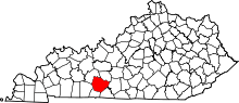 | |
| CDP | ||
| Other unincorporated communities | ||
| Principal city | _Metro.png) | |
|---|---|---|
| Other municipalities | ||
| Counties | ||
