Ellington, Connecticut
| Ellington, Connecticut | ||
|---|---|---|
| Town | ||
|
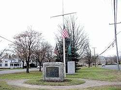
The town green | ||
| ||
| Motto: "A Great Place To Grow"[1] | ||
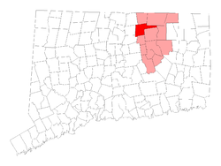 Location in Tolland County, Connecticut | ||
| Coordinates: 41°55′00″N 72°27′28″W / 41.91667°N 72.45778°WCoordinates: 41°55′00″N 72°27′28″W / 41.91667°N 72.45778°W | ||
| Country | United States | |
| State | Connecticut | |
| NECTA | Hartford | |
| Region | Capitol Region | |
| Incorporated | 1786 | |
| Government | ||
| • Type | Selectman-town meeting | |
| • First Selectman | Lori Speilman (R) | |
| • Selectmen |
John W. Turner (R) Ronald F. Stomberg (R) Lori L. Spielman (R) James M. Prichard (R) A. Leo Miller (D) Melinda M. Ferry (D) | |
| Area | ||
| • Total | 34.6 sq mi (89.6 km2) | |
| • Land | 34.1 sq mi (88.2 km2) | |
| • Water | 0.6 sq mi (1.4 km2) | |
| Elevation | 246 ft (75 m) | |
| Population (2010) | ||
| • Total | 15,602 | |
| • Density | 379.4/sq mi (146.5/km2) | |
| Time zone | Eastern (UTC-5) | |
| • Summer (DST) | Eastern (UTC-4) | |
| ZIP code | 06029 | |
| Area code(s) | 860 | |
| FIPS code | 09-25360 | |
| GNIS feature ID | 0212330 | |
| Website |
www | |

Ellington is a town in Tolland County, Connecticut, United States. Ellington was incorporated in May, 1786, from East Windsor. As of the 2010 census, the town population was 15,602.
History
Originally part of the Equivalent Lands and the town of Windsor, Ellington was part of the town of East Windsor from that town's incorporation in 1768 until Ellington split off twenty years later and incorporated itself in May 1786. Mostly known as an agricultural community, the Crystal Lake section of town was for a while a popular summer resort location.[2] Ellington still has a significant amount of property dedicated to agriculture including cattle and corn farming.
Ellington's sole representative to the voting on the adoption of the United States Constitution by Connecticut was Ebenezer Nash. Nash was an anti-federalist and voted against the ratification, which passed 128-40.
Ellington is home to one of America’s oldest roadside memorials. A stone in the southwest corner of the town marks the site where Samuel Knight was killed "by a cartwheel rolling over his head in 10th year of his age, Nov 8, 1812".
During the late 19th century and early 20th century, Ellington became the center of a community of Jewish immigrant farmers who were settled there by the philanthropist Baron Maurice de Hirsch's Jewish Colonization Association. They built a synagogue, Congregation Knesseth Israel,[3] that is still standing and in use by an active Modern Orthodox congregation today and is on the National Register of Historic Places.[4]
On January 1, 1967, Ellington made national news when its residents assisted the city fire department in rescuing a pilot whose plane was having engine trouble and was unable to locate a runway in a fog that cut visibility to 200 feet. Under the direction of the Connecticut State Police, dozens of people assembled at the town's unlit airstrip, Hyde Field, and illuminated the runway with their headlights, allowing the pilot to land safely. [5]
In 1991, Ellington was proposed as a potential site for a low level nuclear waste dump. Strong dissent from area residents forced the state to abandon the plan.[6]
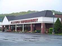
As it enters the 21st Century, Ellington has had the 6th fastest growth rate of all the towns in Connecticut,[7] and has been experiencing changes in growing from a rural farming town to a bedroom community. Exemplative of this change was the displacement of the locally owned Ellington Supermarket by competition from the regional Big Y supermarket chain when a new Big Y was built adjacent to the older supermarket.[8] An independent film entitled The Supermarket, was made about the incident.[9][10]
Geography
According to the United States Census Bureau, the town has a total area of 34.6 square miles (90 km2), of which, 34.0 square miles (88 km2) of it is land and 0.6 square miles (1.6 km2) of it (1.59%) is water.
Ellington is bordered by the towns of East Windsor, South Windsor, Vernon, Tolland, Willington, Stafford, Somers, and Enfield.
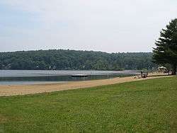
The town has a panhandle extending to the east that extends to the Willimantic River and encompasses Crystal Lake. A large portion of the town's eastern portion is occupied by the Shenipsit State Forest which is bounded on the south by Shenipsit Lake and on the north by Soapstone Mountain.[11]
Neighborhoods
- Crystal Lake
- Ellington Center
- Sadd's Mill
- Highland Ave
- Windermere
- Woodside Acres
- Mosley Plains
- Gasek Farms
- Crystal Ridge
Demographics
| Historical population | |||
|---|---|---|---|
| Census | Pop. | %± | |
| 1820 | 1,196 | — | |
| 1850 | 1,399 | — | |
| 1860 | 1,510 | 7.9% | |
| 1870 | 1,452 | −3.8% | |
| 1880 | 1,569 | 8.1% | |
| 1890 | 1,539 | −1.9% | |
| 1900 | 1,829 | 18.8% | |
| 1910 | 1,999 | 9.3% | |
| 1920 | 2,127 | 6.4% | |
| 1930 | 2,253 | 5.9% | |
| 1940 | 2,479 | 10.0% | |
| 1950 | 3,099 | 25.0% | |
| 1960 | 5,580 | 80.1% | |
| 1970 | 7,707 | 38.1% | |
| 1980 | 9,711 | 26.0% | |
| 1990 | 11,197 | 15.3% | |
| 2000 | 12,921 | 15.4% | |
| 2010 | 15,602 | 20.7% | |
| Est. 2014 | 15,795 | [12] | 1.2% |
As of the census[14] of 2000, there were 12,921 people, 5,195 households, and 3,470 families residing in the town. Ellington's population increased 20.8% between 2000 and 2010, making one of just four municipalities in Connecticut to achieve a growth rate of at least 20% for that period.[15] The population density was 379.4 people per square mile (146.5/km²). There were 5,417 housing units at an average density of 159.1 per square mile (61.4/km²). The racial makeup of the town was 96.23% White, 0.99% African American, 0.16% Native American, 1.29% Asian, 0.01% Pacific Islander, 0.44% from other races, and 0.87% from two or more races. Hispanic or Latino of any race were 1.40% of the population.
There were 5,195 households out of which 32.5% had children under the age of 18 living with them, 57.4% were married couples living together, 6.6% had a female householder with no husband present, and 33.2% were non-families. 26.8% of all households were made up of individuals and 6.4% had someone living alone who was 65 years of age or older. The average household size was 2.48 and the average family size was 3.06.
In the town the population was spread out with 25.2% under the age of 18, 6.5% from 18 to 24, 35.0% from 25 to 44, 23.6% from 45 to 64, and 9.7% who were 65 years of age or older. The median age was 37 years. For every 100 females there were 98.9 males. For every 100 females age 18 and over, there were 96.3 males.
The median income for a household in the town was $62,405, and the median income for a family was $77,813. Males had a median income of $47,334 versus $32,460 for females. The per capita income for the town was $27,766. About 2.7% of families and 3.6% of the population were below the poverty line, including 4.1% of those under age 18 and 3.9% of those age 65 or over.
| Voter Registration and Party Enrollment as of October 25, 2005[16] | |||||
|---|---|---|---|---|---|
| Party | Active Voters | Inactive Voters | Total Voters | Percentage | |
| Republican | 1,926 | 67 | 1,993 | 22.61% | |
| Democratic | 1,905 | 55 | 1,960 | 22.23% | |
| Unaffiliated | 4,679 | 177 | 4,856 | 55.09% | |
| Minor Parties | 5 | 1 | 6 | 0.07% | |
| Total | 8,515 | 300 | 8,815 | 100% | |
Economy
Ellington is a rapidly growing community, and is going through the process of suburbanization,[7][17] which is related to the phenomenon of urban sprawl.
Education
Ellington Public Schools belong to the Ellington Public Schools school district.[18][19] The district has five public schools:
Elementary schools
- Center School (K-6)
- Crystal Lake School (K-6)
- Windermere School (K-6)
Middle school
- Ellington Middle School, formerly Longview Middle School(7-8)
High school
Infrastructure
Roads
Though no Interstate Highways run through it, Ellington is approximately equidistant to both Interstate 84 and Interstate 91, each being about a ten- to fifteen-minute drive from most parts of town.
Several Connecticut State Roads run through town:
- Connecticut Route 30- (Stafford Rd.) The North/South arterial in the Crystal Lake section of town.
- Connecticut Route 83- (West Rd. & Somers Rd.) The main North/South arterial running through the middle of the town.
- Connecticut Route 74- (Wapping Wood Rd. & Windsorville Rd.) On the Southern edge of town, a major road in Ellington's Five corners.
- Connecticut Route 140- (Sadds Mill Rd., Maple St., Crystal Lake Rd., & Sandy Beach Rd.) The town's main East/West arterial, running the complete width of town.
- Connecticut Route 286- (Pinney St. & Main St.) An arterial running North from Five Corners to the center of town where it turns East and becomes Ellington's Main St.
Rail
Ellington was formerly served by a seven-mile-long rail line built in 1876 running from Vernon to Melrose, that roughly paralleled Pinney St. and Sadds Mill Rd. The rail line became defunct in the middle part of the 20th Century.[20]
Airports
- Ellington Airport- A General aviation airport located adjacent to the town's Industrial park on Route 83. In addition to private aviation, a Flight training school and a helicopter school operate there. Parachuting is a common weekend activity from the airport.[21]
- Skylark Airpark- A General aviation airport located in the neighboring town of East Windsor.
- Bradley International Airport- Connecticut's main commercial airport, is located approximately ten miles West of town in Windsor Locks.
Water
Crystal Lake, in the Eastern section of town, is used by many for Recreational boating.
Notable people
- Faisal Alam, born in 1977, moved to Ellington at age ten. Founder of the Al-Fatiha Foundation, an organization for LGBT Muslims.
- John H. Brockway (January 31, 1801 – July 29, 1870), a U.S. Representative.
- Orlow W. Chapman, born in 1832 in Ellington. A New York Politician, he served as the Solicitor General of the United States from May 29, 1889 until his death by pneumonia on January 19, 1890.
- Mike Massaro, NASCAR on NBC pit reporter and journalist.
- Reverend Henry Weston Smith, born January 10, 1827, in Ellington. A Methodist preacher, he was the first of any denomination to preach in the Black Hills of South Dakota, arriving in Deadwood in 1876. Smith was murdered within months of his arrival and is buried in Mount Moriah Cemetery, Deadwood, along with Wild Bill Hickock and Calamity Jane.
- Steve Park - NASCAR Driver who drove in the Sprint Cup Series. Lived here before moving to North Carolina to peruse his dream.
- Mike Vranos, born August 1961, founder of the hedge fund Ellington Management Company.
See also
References
- ↑ "Town of Ellington Connecticut". Town of Ellington Connecticut. Retrieved September 22, 2012.
- ↑ Staff; "Ellington Town Information"; The Hartford Courant; August 16, 2006
- ↑ Raider, Mark; Jewish Immigrant Farmers in the Connecticut Valley: The Rockville Settlement
- ↑ The National Register of Historic Places listings for Tolland County, Connecticut
- ↑ "Town Guides Lost Plane to Safe Landing— Light Small Airstrip with Cars, Trucks", Chicago Tribune, January 2, 1964, p1A-2
- ↑ "NUCLEAR WASTE Connecticut’s First Site Selection Process for a Disposal Facility";Report to Congressional Requesters U.S. General Accounting Office; April 1993
- ↑ "Customers Bemoan The Imminent Closing Of Ellington Supermarket"; Journal Inquirer; July 8 2006
- ↑ "Former Employee Turns Ellington Supermarket Into Film Icon"; Journal Inquirer; November 10 2006
- ↑ "Former Supermarket Worker Makes Film At Old Store"; Progressive Grocer; November 15 2006
- ↑ Map of Shenipsit State Forest; Connecticut DEP
- ↑ "Annual Estimates of the Resident Population for Incorporated Places: April 1, 2010 to July 1, 2014". Retrieved June 4, 2015.
- ↑ "Census of Population and Housing". Census.gov. Retrieved June 4, 2015.
- ↑ "American FactFinder". United States Census Bureau. Retrieved 2008-01-31.
- ↑ http://www.census.gov/prod/cen2010/cph-2-8.pdf "Connecticut: 2010 Population and Housing Unit Counts," U.S. Census Bureau, June 2012, page 32. Retrieved May 18, 2014.
- ↑ "Registration and Party Enrollment Statistics as of October 25, 2005" (PDF). Connecticut Secretary of State. Archived from the original (PDF) on 2006-09-23. Retrieved 2006-10-02.
- ↑ Sacks, Michael P. (September 2004). "Suburban Sprawl, Urban Decline and Racial/Ethnic Segregation: Shifting Dimensions of Inequality in a U.S. Metro Area" (PDF). The Office of Population Research at Princeton University. Retrieved 2007-01-30.
- ↑ "Ellington Public Schools". Ellington Public Schools. Retrieved September 22, 2012.
- ↑ "Ellington School Districtn School District". Great Schools, Inc. Retrieved September 19, 2012.
- ↑ Vernon Depot/The Hartford, Providence & Fishkill Railroad/Vernon, Connecticut
- ↑ Airnav.com summary for Ellington Airport (7B9)
External links
| Wikimedia Commons has media related to Ellington, Connecticut. |
| Wikivoyage has a travel guide for Ellington. |
- Town of Ellington Connecticut Portal style website, Government, Business, Library, Recreation and more
- Ellington Public Schools
- Central Regional Tourism District
- City-Data.com Comprehensive Statistical Data and more about Tipton
Municipalities and communities of Tolland County, Connecticut, United States | ||
|---|---|---|
| Towns | 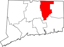 | |
| Other communities | ||
