McKenzie Bridge State Airport
| McKenzie Bridge State Airport | |||||||||||
|---|---|---|---|---|---|---|---|---|---|---|---|
| IATA: none – ICAO: none – FAA LID: 00S | |||||||||||
| Summary | |||||||||||
| Airport type | Public | ||||||||||
| Operator | Oregon Department of Aviation | ||||||||||
| Location | McKenzie Bridge, Oregon | ||||||||||
| Elevation AMSL | 1,620 ft / 494 m | ||||||||||
| Coordinates | 44°10′59.4400″N 122°05′19.20″W / 44.183177778°N 122.0886667°WCoordinates: 44°10′59.4400″N 122°05′19.20″W / 44.183177778°N 122.0886667°W | ||||||||||
| Runways | |||||||||||
| |||||||||||
McKenzie Bridge State Airport (FAA LID: 00S), is a public airport located 3 miles (4.8 km) east of McKenzie Bridge, in Lane County, Oregon, USA.
 Runway 24
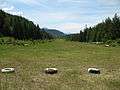
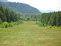 Close up RY 24
External links
- Resources for this airport:
- FAA airport information for 00S
- AirNav airport information for 00S
- FlightAware airport information and live flight tracker
- SkyVector aeronautical chart for 00S
This article is issued from Wikipedia - version of the 10/29/2016. The text is available under the Creative Commons Attribution/Share Alike but additional terms may apply for the media files.