Mer de Glace
| Mer de Glace | |
|---|---|
| Sea of Ice | |
|
Mer de Glace | |
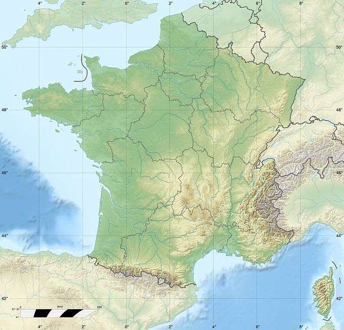 Mer de Glace located in France Map | |
| Location | Northern slopes of the Mont Blanc massif |
| Coordinates | 45°54′58″N 6°56′14″E / 45.91611°N 6.93722°ECoordinates: 45°54′58″N 6°56′14″E / 45.91611°N 6.93722°E |
| Length | 7 km (4.3 mi) |
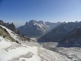
The Mer de Glace is a valley glacier located on the northern slopes of the Mont Blanc massif, in the French Alps. It is 5.5 kilometres (3.4 mi) long and 200 metres (660 ft) deep but, when all its tributary glaciers are taken into account, it can be regarded as the longest and largest glacier in France, and the second longest in the Alps after the Aletsch Glacier.[1][2]:5,20
I can no otherwise convey to you an image of this body of ice, broken into irregular ridges and deep chasms than by comparing it to waves instantaneously frozen in the midst of a violent storm.— William Coxe 1777
Geography

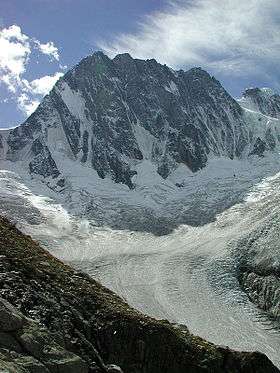
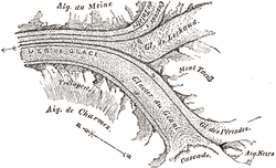
In its strictest sense, the Mer de Glace can be considered as originating at an elevation of 2,100 metres (6,900 ft), just north of the Aiguille du Tacul, where it is formed by the confluence of the Glacier de Leschaux and the Glacier du Tacul. The former is fed by the Glacier du Talefre, whilst the latter is, in turn, fed by the Glacier des Periardes, the vast Glacier du Géant and the broad icefields of the Vallee Blanche. The Glacier du Tacul supplies much more ice than the Glacier de Leschaux.[2]:20
However, if the Mer de Glace is considered in its broadest sense (i.e. from source to tongue), it is a compound valley glacier, gaining ice from snowfields that cover the heights directly north of Mont Blanc at an altitude of around 4,000 metres. It flows for a total distance of 12 kilometres, covering an area of 32 square kilometres in the central third of the Mont Blanc massif.[2]:6,21
From the Aiguille du Tacul, the Mer de Glace flows north-north-west between Aiguille du Moine on the east and Trélaporte on the west. It descends below Montenvers, at which point it is approximately 0.5 km wide, and descends to approximately 1,500 metres (4,900 ft). The glacier was once easily visible from Chamonix but has been shrinking backwards, and is now barely visible from below.[2]:20[3] The surface topography of the Mer de Glace changed very little during the first third of the 20th century, but from 1939 to 2001 the surface of the glacier has lowered an average of 30 cm each year, corresponding to an equivalent loss of 700 million cubic metres of water.[2]:126
The glacier lies above the Chamonix valley, and was the first place in the region to have a ready-made tourist attraction.
Like all glaciers, the Mer de Glace is in balance between two phenomena: accumulation, notably due to winter snowfall, and ablation, essentially due to summer melting. The Mer de Glace flows continuously under the effect of its own weight, causing crevasses, seracs or pockets of water to form, depending on the terrain over which it moves. Its speed, although not perceptible to the naked eye, is considerable. From more than 120 metres (390 ft) a year in its upper part, the Mer de Glace moves about 90 metres (300 ft) per year in the region of Montenvers, which is about one centimetre per hour.. The pressure within the ice is known to reach at least 30 atmospheres.[4]
When the tension in the ice increases as the slope increases, the glacier is unable to deform and crevasses appear. These are notably transversal and, when there is intense crevasse activity on the steepest terrain, blocks of seracs appear as the glacier breaks up. Crevasses are of variable depth, depending on their position, and may be as deep as fifty metres. Seracs always form in the same places, namely the steepest sections over which the glacier flows. As crevasses open and seracs tumble downstream, the supply of ice is renewed by the constant flow from upstream. Broad banding patterns, visible on the surface of the Mer de Glace, are known as ogives, or Forbes bands, and result from differences in summer and winter collapse rates of the serac fields. It was on 24 July 1842 that Scottish physicist James David Forbes observed the pattern of light and dark dirt bands on the Mer de Glace from the nearby Charmoz and began to consider whether glaciers flowed in a similar fashion to a sluggish river and with a viscous or plastic manner.[5]
History
In the 18th and 19th centuries the glacier descended all the way down to the hamlet of LesBos,[3] where it was known as Glacier des Bois. At that time the river Arveyron emerged from the glacier under a grotto-like vault (grotte d'Arveyron)[6] and, through the accounts of early writers and explorers,[7] attracted many more visitors, painters and later photographers, for example Joseph Mallord William Turner's "Source of the Arveron in the Valley of Chamouni Savoy", 1816. The position of its front end fluctuated over the years but its maximum extent was in the mid-19th century.[3]
Electricity generation
Sub glacial waters from the Mer de Glace are used seasonally by EDF for the generation of hydroelectricity. Tunnels bored under the glacier collect water from the base of the glacier and channel it down to a hydropower plant in the valley. This water is then discharged into the Arveyron further downstream.
See also
Notes
- ↑ La Mer de Glace - Chamonix Mont Blanc
- 1 2 3 4 5 Nussbaumer, S.U.; Zumbuhl, H.J.; Steiner, D. (2007). "Fluctuations of the "Mer de Glace" (Mont Blanc area, France) AD 1500–2050:" (PDF). Zeitschrift für Gletscherkunde und Glazialgeologie. Innsbruck. BAND 40 (2005/2006): 1–137. ISSN 0044-2836. Retrieved 13 January 2016.
- 1 2 3 (Grove pages 121-122, "in 1820 ... sixty yards")
- ↑ Nye, J.F. (1952). "The Mechanics of Glacier Flow" (PDF). Journal of Glaciology: 82. Retrieved 13 January 2016.
- ↑ Shairp, John Campbell; Tait, Peter Guthrie; Adams-Reilly, Anthony (1873). Life and Letters of James David Forbes, F.R.S., D.C.L., LL. D etc. London: Macmillan and Co. p. 527. Retrieved 13 January 2016.
- ↑ Tyndall page 38, "In former times the whole volume of the Arveiron escaped from beneath the ice at the end of the glacier, forming a fine arch at its place of issue."
- ↑ William Coxe (1777). Pinkerton, John, ed. Travels in Switzerland and in the Country of the Grisons 1777 (in 'A General Collection of the Best and Most Interesting Voyages', Vol.5 1809). p. 781. Retrieved 14 February 2016.
References
- Jean M. Grove (1988). The Little Ice Age. ISBN 0-415-01449-2.
- John Tyndall (1896). The Glaciers of the Alps. Longmans, Green and Co. NEW EDITION (reprinted as ISBN 1-4212-0908-X)
- Fournier, Andre (2005). Mer de Glace (English version ed.). ISBN 2842062620. Retrieved 18 January 2016.
External links
| Wikimedia Commons has media related to Mer de Glace. |
- Mer de Glace and associated glaciers on French IGN mapping portal
- 360° photo from surface of Mer de Glace on Google StreetView