Dôme du Goûter
| Dôme du Goûter | |
|---|---|
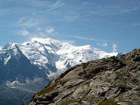 Mont Blanc (centre left) and the Dôme du Goûter (right) | |
| Highest point | |
| Elevation | 4,304 m (14,121 ft) |
| Prominence | 58 m ↓ Col du Dôme [1] |
| Isolation | 1.98 km → Mont Blanc |
| Coordinates | 45°50′34″N 6°50′36″E / 45.84278°N 6.84333°ECoordinates: 45°50′34″N 6°50′36″E / 45.84278°N 6.84333°E |
| Geography | |
 Dôme du Goûter Alps | |
| Location | Haute-Savoie, France / Italy |
| Parent range | Graian Alps |
| Geology | |
| Mountain type | Granite/Porphyry |
| Climbing | |
| First ascent | 17 September 1784 by Jean-Marie Couttet and François Cuidet |
| Easiest route | From Refuge du Goûter, 3,817 m, (F) |
The Dôme du Goûter (4,304 m) is a mountain in the Mont Blanc massif. It is a shoulder of Mont Blanc, whose summit lies two kilometres to the south-east. The Dôme is traversed on ascents of Mont Blanc via the Bosses route.
The summit of the Dôme is marked as lying entirely within France on the French Institut Géographique National (IGN) map , although on Italian Istituto Geografico Militare (IGM) map the summit appears to lie on the frontier between France and Italy.
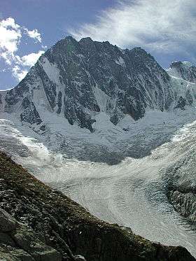
The summit of the Dôme du Goûter
References
External links

This article is issued from Wikipedia - version of the 2/20/2016. The text is available under the Creative Commons Attribution/Share Alike but additional terms may apply for the media files.