Miltonsburg, Ohio
| Miltonsburg, Ohio | |
|---|---|
| Village | |
|
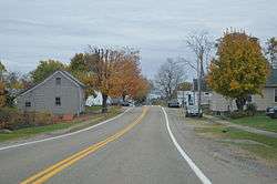
Along Main Street | |
 Location of Miltonsburg, Ohio | |
 Detailed map of Miltonsburg | |
| Coordinates: 39°49′53″N 81°10′00″W / 39.83139°N 81.16667°W | |
| Country | United States |
| State | Ohio |
| County | Monroe |
| Township | Malaga |
| Area[1] | |
| • Total | 0.07 sq mi (0.18 km2) |
| • Land | 0.07 sq mi (0.18 km2) |
| • Water | 0 sq mi (0 km2) |
| Elevation[2] | 1,296 ft (395 m) |
| Population (2010)[3] | |
| • Total | 43 |
| • Estimate (2012[4]) | 43 |
| • Density | 614.3/sq mi (237.2/km2) |
| Time zone | Eastern (EST) (UTC-5) |
| • Summer (DST) | EDT (UTC-4) |
| FIPS code | 39-50722[5] |
| GNIS feature ID | 1051007[2] |
Miltonsburg is a village in Monroe County, Ohio, United States. The population was 43 at the 2010 census.[6]
Miltonsburg is served by the Monroe County District Library from its administrative offices in Woodsfield.
Geography
Miltonsburg is located at 39°49′53″N 81°10′00″W / 39.831350°N 81.166541°WCoordinates: 39°49′53″N 81°10′00″W / 39.831350°N 81.166541°W (39.831350, -81.166541).[7]
According to the United States Census Bureau, the village has a total area of 0.07 square miles (0.18 km2), all of it land.[1]
Demographics
| Historical population | |||
|---|---|---|---|
| Census | Pop. | %± | |
| 1850 | 145 | — | |
| 1870 | 176 | — | |
| 1880 | 152 | −13.6% | |
| 1890 | 123 | −19.1% | |
| 1900 | 130 | 5.7% | |
| 1910 | 92 | −29.2% | |
| 1920 | 84 | −8.7% | |
| 1930 | 69 | −17.9% | |
| 1940 | 86 | 24.6% | |
| 1950 | 100 | 16.3% | |
| 1960 | 116 | 16.0% | |
| 1970 | 68 | −41.4% | |
| 1980 | 109 | 60.3% | |
| 1990 | 56 | −48.6% | |
| 2000 | 29 | −48.2% | |
| 2010 | 43 | 48.3% | |
| Est. 2015 | 43 | [8] | 0.0% |
2010 census
As of the census[3] of 2010, there were 43 people, 19 households, and 12 families residing in the village. The population density was 614.3 inhabitants per square mile (237.2/km2). There were 25 housing units at an average density of 357.1 per square mile (137.9/km2). The racial makeup of the village was 100.0% White.
There were 19 households of which 36.8% had children under the age of 18 living with them, 47.4% were married couples living together, 10.5% had a female householder with no husband present, 5.3% had a male householder with no wife present, and 36.8% were non-families. 31.6% of all households were made up of individuals. The average household size was 2.26 and the average family size was 2.67.
The median age in the village was 42.8 years. 20.9% of residents were under the age of 18; 4.7% were between the ages of 18 and 24; 35% were from 25 to 44; 28% were from 45 to 64; and 11.6% were 65 years of age or older. The gender makeup of the village was 55.8% male and 44.2% female.
2000 census
As of the census[5] of 2000, there were 29 people, 11 households, and 8 families residing in the village. The population density was 376.3 people per square mile (140.0/km²). There were 11 housing units at an average density of 142.7 per square mile (53.1/km²). The racial makeup of the village was 100.00% White.
There were 11 households out of which 36.4% had children under the age of 18 living with them, 72.7% were married couples living together, and 18.2% were non-families. 18.2% of all households were made up of individuals and 18.2% had someone living alone who was 65 years of age or older. The average household size was 2.64 and the average family size was 2.89.
In the village the population was spread out with 24.1% under the age of 18, 3.4% from 18 to 24, 37.9% from 25 to 44, 20.7% from 45 to 64, and 13.8% who were 65 years of age or older. The median age was 37 years. For every 100 females there were 107.1 males. For every 100 females age 18 and over, there were 100.0 males.
The median income for a household in the village was $43,750, and the median income for a family was $43,750. Males had a median income of $39,583 versus $0 for females. The per capita income for the village was $13,605. None of the population is below the poverty line.
References
- 1 2 "US Gazetteer files 2010". United States Census Bureau. Retrieved 2013-01-06.
- 1 2 "US Board on Geographic Names". United States Geological Survey. 2007-10-25. Retrieved 2008-01-31.
- 1 2 "American FactFinder". United States Census Bureau. Retrieved 2013-01-06.
- ↑ "Population Estimates". United States Census Bureau. Retrieved 2013-06-17.
- 1 2 "American FactFinder". United States Census Bureau. Retrieved 2008-01-31.
- ↑ "Profile of General Population and Housing Characteristics: 2010 Demographic Profile Data (DP-1): Miltonsburg village, Ohio". U.S. Census Bureau, American Factfinder. Retrieved June 1, 2012.
- ↑ "US Gazetteer files: 2010, 2000, and 1990". United States Census Bureau. 2011-02-12. Retrieved 2011-04-23.
- ↑ "Annual Estimates of the Resident Population for Incorporated Places: April 1, 2010 to July 1, 2015". Retrieved July 2, 2016.
- ↑ "Census of Population and Housing". Census.gov. Retrieved June 4, 2015.
Municipalities and communities of Monroe County, Ohio, United States | ||
|---|---|---|
| Villages |  | |
| Townships | ||
| CDPs | ||
| Unincorporated communities | ||
| Ghost town | ||
| Footnotes | ‡This populated place also has portions in an adjacent county or counties | |