Monroe County, Ohio
| Monroe County, Ohio | ||
|---|---|---|
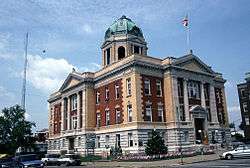 Monroe County Courthouse | ||
| ||
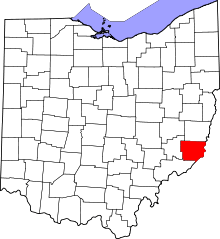 Location in the U.S. state of Ohio | ||
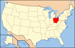 Ohio's location in the U.S. | ||
| Founded | March 1, 1815 | |
| Named for | James Monroe | |
| Seat | Woodsfield | |
| Largest village | Woodsfield | |
| Area | ||
| • Total | 457 sq mi (1,184 km2) | |
| • Land | 456 sq mi (1,181 km2) | |
| • Water | 1.7 sq mi (4 km2), 0.4% | |
| Population | ||
| • (2010) | 14,642 | |
| • Density | 32/sq mi (12/km²) | |
| Congressional district | 6th | |
| Time zone | Eastern: UTC-5/-4 | |
| Website |
www | |

Monroe County is a county located in the U.S. state of Ohio. As of the 2010 census, the population was 14,642,[1] making it the second-least populous county in Ohio. Its county seat is Woodsfield.[2] The county was created in 1813 and later organized in 1815.[3]
History
Monroe County was formed on January 28, 1813 from portions of Belmont, Guernsey and Washington counties. It was named after James Monroe, the U.S. Secretary of State when the county was formed, and later fifth President of the United States.[4]
On or about December 20, 2011, Exxon Mobil Corp., a New Jersey petroleum company, via its subsidiary XTO Energy, acquired 20,056 acres of Monroe County Utica Shale gas leases from Beck Energy.[5]
Geography
According to the U.S. Census Bureau, the county has a total area of 457 square miles (1,180 km2), of which 456 square miles (1,180 km2) is land and 1.7 square miles (4.4 km2) (0.4%) is water.[6]
Adjacent counties
- Belmont County (north)
- Marshall County, West Virginia (northeast)
- Wetzel County, West Virginia (east)
- Tyler County, West Virginia (southeast)
- Washington County (south)
- Noble County (west)
National protected area
- Wayne National Forest (part)
Demographics
| Historical population | |||
|---|---|---|---|
| Census | Pop. | %± | |
| 1820 | 4,645 | — | |
| 1830 | 8,768 | 88.8% | |
| 1840 | 18,521 | 111.2% | |
| 1850 | 28,351 | 53.1% | |
| 1860 | 25,741 | −9.2% | |
| 1870 | 25,779 | 0.1% | |
| 1880 | 26,496 | 2.8% | |
| 1890 | 25,175 | −5.0% | |
| 1900 | 27,031 | 7.4% | |
| 1910 | 24,244 | −10.3% | |
| 1920 | 20,660 | −14.8% | |
| 1930 | 18,426 | −10.8% | |
| 1940 | 18,641 | 1.2% | |
| 1950 | 15,362 | −17.6% | |
| 1960 | 15,268 | −0.6% | |
| 1970 | 15,739 | 3.1% | |
| 1980 | 17,382 | 10.4% | |
| 1990 | 15,497 | −10.8% | |
| 2000 | 15,180 | −2.0% | |
| 2010 | 14,642 | −3.5% | |
| Est. 2015 | 14,409 | [7] | −1.6% |
| U.S. Decennial Census[8] 1790-1960[9] 1900-1990[10] 1990-2000[11] 2010-2013[1] | |||
2000 census
As of the census[12] of 2000, there were 15,180 people, 6,021 households, and 4,413 families residing in the county. The population density was 33 people per square mile (13/km²). There were 7,212 housing units at an average density of 16 per square mile (6/km²). The racial makeup of the county was 98.72% White, 0.26% Black or African American, 0.15% Native American, 0.07% Asian, 0.01% Pacific Islander, 0.11% from other races, and 0.67% from two or more races. 0.41% of the population were Hispanic or Latino of any race.
There were 6,021 households out of which 29.50% had children under the age of 18 living with them, 61.70% were married couples living together, 8.10% had a female householder with no husband present, and 26.70% were non-families. 24.00% of all households were made up of individuals and 11.50% had someone living alone who was 65 years of age or older. The average household size was 2.50 and the average family size was 2.96.
In the county, the population was spread out with 23.60% under the age of 18, 7.10% from 18 to 24, 25.90% from 25 to 44, 27.20% from 45 to 64, and 16.30% who were 65 years of age or older. The median age was 41 years. For every 100 females there were 97.50 males. For every 100 females age 18 and over, there were 96.10 males.
The median income for a household in the county was $30,467, and the median income for a family was $36,297. Males had a median income of $33,308 versus $19,628 for females. The per capita income for the county was $15,096. About 11.00% of families and 13.90% of the population were below the poverty line, including 18.30% of those under age 18 and 11.40% of those age 65 or over.
2010 census
As of the 2010 United States Census, there were 14,642 people, 6,065 households, and 4,183 families residing in the county.[13] The population density was 32.1 inhabitants per square mile (12.4/km2). There were 7,567 housing units at an average density of 16.6 per square mile (6.4/km2).[14] The racial makeup of the county was 98.1% white, 0.4% black or African American, 0.1% Asian, 0.1% American Indian, 0.1% from other races, and 1.2% from two or more races. Those of Hispanic or Latino origin made up 0.4% of the population.[13] In terms of ancestry, 34.8% were German, 14.5% were Irish, 10.6% were English, and 9.6% were American.[15]
Of the 6,065 households, 27.3% had children under the age of 18 living with them, 56.0% were married couples living together, 8.6% had a female householder with no husband present, 31.0% were non-families, and 27.3% of all households were made up of individuals. The average household size was 2.39 and the average family size was 2.87. The median age was 44.7 years.[13]
The median income for a household in the county was $37,030 and the median income for a family was $43,261. Males had a median income of $39,261 versus $24,922 for females. The per capita income for the county was $18,738. About 12.3% of families and 17.3% of the population were below the poverty line, including 26.7% of those under age 18 and 12.3% of those age 65 or over.[16]
Politics
| Year | Republican | Democrat |
|---|---|---|
| 2016 | 71.03% 4,868 | 24.25% 1,662 |
| 2012 | 52.31% 3,548 | 44.75% 3,035 |
| 2008 | 43.91% 3,066 | 53.07% 3,705 |
| 2004 | 44.30% 3,424 | 54.90% 4,243 |
| 2000 | 44.20% 3,145 | 50.67% 3,605 |
Government
Monroe County has three County Commissioners who oversee the various County departments, similar to 85 of the other 88 Ohio counties. Current Commissioners, all Democrats, are: John V. Pyles, Tim Price, and Carl Davis.[18]
Monroe County is served by the Monroe County District Library from its administrative offices in Woodsfield, Ohio; it also offers a bookmobile service.
In 2005, the library loaned more than 141,000 items to its 6,000 cardholders. Total holding are over 64,000 volumes with over 140 periodical subscriptions.[19] This library is a member of the SOLO Regional Library System.
Education
Monroe County contains the following schools through the Switzerland of Ohio Local School District:
- Elementary Schools
- Beallsville Elementary School in Beallsville, Ohio
- River Elementary School in Hannibal, Ohio
- Skyvue Elementary School in Graysville, Ohio
- Woodsfield Elementary School in Woodsfield, Ohio
- St.Sylvester Central in Woodsfield, Ohio
- High Schools
- Monroe Central High School in Woodsfield, Ohio
- River High School in Hannibal, Ohio
- Beallsville High School in Beallsville, Ohio
- Career Center
- Swiss Hills Career Center in Woodsfield, Ohio
Communities
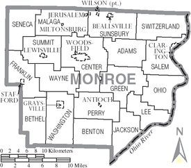
Villages
- Antioch
- Beallsville
- Clarington
- Graysville
- Jerusalem
- Lewisville
- Miltonsburg
- Stafford
- Wilson
- Woodsfield (county seat)
Townships
Census-designated places
Unincorporated communities
- Altitude
- Calais
- Cameron
- Fly
- Herlan
- Laings
- Malaga
- Marr
- Quarry
- Rinard Mills
- Swazey
- Sycamore Valley
Notable people
- Philip Allen, member of the Wisconsin State Assembly.[20]
- Sam V. Stewart, Montana Supreme Court Justice and the sixth Governor of Montana.[21]
See also
References
- 1 2 "State & County QuickFacts". United States Census Bureau. Retrieved February 9, 2015.
- ↑ "Find a County". National Association of Counties. Retrieved 2011-06-07.
- ↑ "Ohio: Individual County Chronologies". Ohio Atlas of Historical County Boundaries. The Newberry Library. 2007. Retrieved February 14, 2015.
- ↑ "Monroe County data". Ohio State University Extension Data Center. Archived from the original on November 12, 2013. Retrieved 2007-04-28.
- ↑ http://marcellusdrilling.com/2012/01/correction-exxon-buys-25k-acres-of-utica-shale-leases-in-oh/
- ↑ "2010 Census Gazetteer Files". United States Census Bureau. August 22, 2012. Retrieved February 9, 2015.
- ↑ "County Totals Dataset: Population, Population Change and Estimated Components of Population Change: April 1, 2010 to July 1, 2015". Retrieved July 2, 2016.
- ↑ "U.S. Decennial Census". United States Census Bureau. Retrieved February 9, 2015.
- ↑ "Historical Census Browser". University of Virginia Library. Retrieved February 9, 2015.
- ↑ Forstall, Richard L., ed. (March 27, 1995). "Population of Counties by Decennial Census: 1900 to 1990". United States Census Bureau. Retrieved February 9, 2015.
- ↑ "Census 2000 PHC-T-4. Ranking Tables for Counties: 1990 and 2000" (PDF). United States Census Bureau. April 2, 2001. Retrieved February 9, 2015.
- ↑ "American FactFinder". United States Census Bureau. Retrieved 2008-01-31.
- 1 2 3 "DP-1 Profile of General Population and Housing Characteristics: 2010 Demographic Profile Data". United States Census Bureau. Retrieved 2015-12-27.
- ↑ "Population, Housing Units, Area, and Density: 2010 - County". United States Census Bureau. Retrieved 2015-12-27.
- ↑ "DP02 SELECTED SOCIAL CHARACTERISTICS IN THE UNITED STATES – 2006-2010 American Community Survey 5-Year Estimates". United States Census Bureau. Retrieved 2015-12-27.
- ↑ "DP03 SELECTED ECONOMIC CHARACTERISTICS – 2006-2010 American Community Survey 5-Year Estimates". United States Census Bureau. Retrieved 2015-12-27.
- ↑ "Dave Leip's Atlas of U.S. Presidential Elections". Retrieved 2016-03-27.
- ↑ "County Offices-County Commissioners". Monroe County Ohio Homepage. Retrieved October 22, 2012.
- ↑ "2005 Ohio Public Library Statistics:Statistics by County and Town". State Library of Ohio. Archived from the original on September 24, 2006. Retrieved October 3, 2006.
- ↑ THE BLUE BOOK OF THE STATE OF WISCONSIN. 1889. p. 508.
- ↑ "Montana Governor Samuel Vernon Stewart". National Governors Association. Retrieved October 10, 2012.
Further reading
- Thomas William Lewis, History of Southeastern Ohio and the Muskingum Valley, 1788-1928. In Three Volumes. Chicago: S.J. Clarke Publishing Co., 1928.
External links
 |
Belmont County | Marshall County, West Virginia | | |
| Noble County | |
Wetzel County, West Virginia | ||
| ||||
| | ||||
| Washington County | Tyler County, West Virginia |
Municipalities and communities of Monroe County, Ohio, United States | ||
|---|---|---|
| Villages | | |
| Townships | ||
| CDPs | ||
| Unincorporated communities | ||
| Ghost town | ||
| Footnotes | ‡This populated place also has portions in an adjacent county or counties | |
Coordinates: 39°44′N 81°05′W / 39.73°N 81.08°W