Mineral Wells, Mississippi
| Mineral Wells, Mississippi | |
|---|---|
| Unincorporated community | |
 Mineral Wells  Mineral Wells | |
| Coordinates: 34°59′26″N 89°51′56″W / 34.99056°N 89.86556°WCoordinates: 34°59′26″N 89°51′56″W / 34.99056°N 89.86556°W | |
| Country | United States |
| State | Mississippi |
| County | Desoto |
| Elevation | 335 ft (102 m) |
| Time zone | Central (CST) (UTC-6) |
| • Summer (DST) | CDT (UTC-5) |
| ZIP code | 38654 |
| Area code(s) | 662 |
| GNIS feature ID | 690337[1] |
Mineral Wells is an unincorporated community located in central DeSoto County, Mississippi, United States, near the Mississippi/Tennessee border just south of Memphis and approximately 3 miles (4.8 km) north of Olive Branch on Mississippi Highway 178.
References
Municipalities and communities of DeSoto County, Mississippi, United States | ||
|---|---|---|
| Cities | 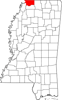 | |
| Town | ||
| CDPs | ||
| Other communities | ||


This article is issued from Wikipedia - version of the 7/30/2016. The text is available under the Creative Commons Attribution/Share Alike but additional terms may apply for the media files.