Mingo Township, Bates County, Missouri
| Mingo Township | |
|---|---|
| Township | |
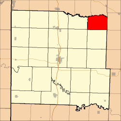 Location in Bates County | |
| Coordinates: 38°25′08″N 94°07′06″W / 38.41889°N 94.11833°WCoordinates: 38°25′08″N 94°07′06″W / 38.41889°N 94.11833°W | |
| Country |
|
| State |
|
| County | Bates |
| Area | |
| • Total | 25.86 sq mi (66.99 km2) |
| • Land | 25.82 sq mi (66.87 km2) |
| • Water | 0.04 sq mi (0.12 km2) 0.18% |
| Elevation | 866 ft (264 m) |
| Population (2000) | |
| • Total | 235 |
| • Density | 9.1/sq mi (3.5/km2) |
| Time zone | CST (UTC-6) |
| • Summer (DST) | CDT (UTC-5) |
| ZIP codes | 64720, 64747, 64788 |
| GNIS feature ID | 0766299 |
Mingo Township is one of twenty-four townships in Bates County, Missouri, USA. As of the 2000 census, its population was 235.[1]
The township takes its name from Mingo Creek.[2]
Geography
According to the United States Census Bureau, Mingo Township covers an area of 25.86 square miles (66.99 square kilometers); of this, 25.82 square miles (66.87 square kilometers, 99.82 percent) is land and 0.04 square miles (0.12 square kilometers, 0.18 percent) is water.
Unincorporated towns
- Aaron at 38°25′23″N 94°09′14″W / 38.423073°N 94.153833°W
- Mayesburg at 38°24′09″N 94°05′10″W / 38.402519°N 94.086054°W
(This list is based on USGS data and may include former settlements.)
Adjacent townships
- Sherman Township, Cass County (north)
- White Oak Township, Henry County (east)
- Walker Township, Henry County (southeast)
- Spruce Township (south)
- Shawnee Township (southwest)
- Grand River Township (west)
- Dayton Township, Cass County (northwest)
Cemeteries
The township contains these four cemeteries: Cove Creek, Earheart, Gragg and Peter Creek.
Rivers
- South Grand River
Lakes
- Clear Lake
- Sprig Lake
School districts
- Adrian County R-III
- Ballard R-II
Political districts
- Missouri's 4th congressional district
- State House District 120
- State Senate District 31
References
- United States Census Bureau 2008 TIGER/Line Shapefiles
- United States Board on Geographic Names (GNIS)
- United States National Atlas
- ↑ United States Census Bureau American FactFinder
- ↑ "Bates County Place Names, 1928-1945 (archived)". The State Historical Society of Missouri. Retrieved 1 September 2016.
External links
 |
Dayton Township, Cass County | Sherman Township, Cass County | | |
| Grand River Township | |
White Oak Township, Henry County | ||
| ||||
| | ||||
| Shawnee Township | Spruce Township | Walker Township, Henry County |
Municipalities and communities of Bates County, Missouri, United States | ||
|---|---|---|
| Cities | 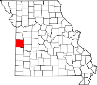 | |
| Villages | ||
| Townships | ||
| Unincorporated communities | ||
| Ghost towns | ||
| Footnotes | ‡This populated place also has portions in an adjacent county or counties | |
This article is issued from Wikipedia - version of the 9/1/2016. The text is available under the Creative Commons Attribution/Share Alike but additional terms may apply for the media files.