Minneapolis, Kansas
| Minneapolis, Kansas | |
|---|---|
| City | |
|
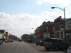
Business District (2009) | |
 Location within Ottawa County and Kansas | |
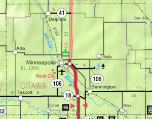 KDOT map of Ottawa County (legend) | |
| Coordinates: 39°7′29″N 97°42′19″W / 39.12472°N 97.70528°WCoordinates: 39°7′29″N 97°42′19″W / 39.12472°N 97.70528°W | |
| Country | United States |
| State | Kansas |
| County | Ottawa |
| Area[1] | |
| • Total | 1.76 sq mi (4.56 km2) |
| • Land | 1.76 sq mi (4.56 km2) |
| • Water | 0 sq mi (0 km2) |
| Elevation | 1,280 ft (390 m) |
| Population (2010)[2] | |
| • Total | 2,032 |
| • Estimate (2012[3]) | 2,022 |
| • Density | 1,200/sq mi (450/km2) |
| Time zone | Central (CST) (UTC-6) |
| • Summer (DST) | CDT (UTC-5) |
| ZIP code | 67467 |
| Area code | 785 |
| FIPS code | 20-47075 [4] |
| GNIS feature ID | 0476284 [5] |
| Website | City Website |
Minneapolis is a city in and the county seat of Ottawa County, Kansas, United States.[6] As of the 2010 census, the city population was 2,032.[7]
History
Minneapolis was originally called Markley's Mills, and under the latter name was laid out in 1866. It was renamed Minneapolis about 1871, after Minneapolis, Minnesota.[8] The railroad was built through Minneapolis in 1878.[9]
Geography
Minneapolis is located at 39°7′29″N 97°42′19″W / 39.12472°N 97.70528°W (39.124719, -97.705209).[10] According to the United States Census Bureau, the city has a total area of 1.76 square miles (4.56 km2), all of it land.[1]
Area attractions
- Rock City, park is located southwest of Minneapolis.
Demographics
| Historical population | |||
|---|---|---|---|
| Census | Pop. | %± | |
| 1880 | 1,084 | — | |
| 1890 | 1,756 | 62.0% | |
| 1900 | 1,727 | −1.7% | |
| 1910 | 1,895 | 9.7% | |
| 1920 | 1,842 | −2.8% | |
| 1930 | 1,741 | −5.5% | |
| 1940 | 2,087 | 19.9% | |
| 1950 | 1,801 | −13.7% | |
| 1960 | 2,024 | 12.4% | |
| 1970 | 1,971 | −2.6% | |
| 1980 | 2,075 | 5.3% | |
| 1990 | 1,983 | −4.4% | |
| 2000 | 2,046 | 3.2% | |
| 2010 | 2,032 | −0.7% | |
| Est. 2015 | 2,002 | [11] | −1.5% |
| U.S. Decennial Census | |||

Minneapolis is part of the Salina Micropolitan Statistical Area.
2010 census
As of the census[2] of 2010, there were 2,032 people, 832 households, and 528 families residing in the city. The population density was 1,154.5 inhabitants per square mile (445.8/km2). There were 919 housing units at an average density of 522.2 per square mile (201.6/km2). The racial makeup of the city was 96.1% White, 1.2% African American, 0.2% Native American, 0.1% Asian, 0.6% from other races, and 1.8% from two or more races. Hispanic or Latino of any race were 2.7% of the population.
There were 832 households of which 32.1% had children under the age of 18 living with them, 48.8% were married couples living together, 10.2% had a female householder with no husband present, 4.4% had a male householder with no wife present, and 36.5% were non-families. 33.2% of all households were made up of individuals and 16.7% had someone living alone who was 65 years of age or older. The average household size was 2.32 and the average family size was 2.94.
The median age in the city was 40 years. 26.4% of residents were under the age of 18; 5% were between the ages of 18 and 24; 23.6% were from 25 to 44; 24.3% were from 45 to 64; and 20.7% were 65 years of age or older. The gender makeup of the city was 50.4% male and 49.6% female.
2000 census
As of the census[4] of 2000, there were 2,046 people, 810 households, and 512 families residing in the city. The population density was 1,173.6 people per square mile (454.0/km²). There were 914 housing units at an average density of 524.3 per square mile (202.8/km²). The racial makeup of the city was 96.97% White, 1.32% African American, 0.24% Native American, 0.05% Asian, 0.29% from other races, and 1.12% from two or more races. Hispanic or Latino of any race were 1.52% of the population.
There were 810 households out of which 29.6% had children under the age of 18 living with them, 53.1% were married couples living together, 8.0% had a female householder with no husband present, and 36.7% were non-families. 33.3% of all households were made up of individuals and 18.9% had someone living alone who was 65 years of age or older. The average household size was 2.29 and the average family size was 2.92.
In the city the population was spread out with 22.9% under the age of 18, 7.5% from 18 to 24, 25.0% from 25 to 44, 21.5% from 45 to 64, and 23.1% who were 65 years of age or older. The median age was 41 years. For every 100 females there were 91.0 males. For every 100 females age 18 and over, there were 88.2 males.
The median income for a household in the city was $34,792, and the median income for a family was $43,750. Males had a median income of $29,028 versus $21,174 for females. The per capita income for the city was $17,628. About 3.7% of families and 9.7% of the population were below the poverty line, including 8.4% of those under age 18 and 16.8% of those age 65 or over.
Notable people
- George Washington Carver, who lived in the vicinity for a brief period.
- Alyssa George, former Miss Kansas 2007
- Rollin Rees, former U.S. Representative from Kansas
- Alexander Riddle, 11th Lieutenant Governor of Kansas and publisher of the Minneapolis Messenger newspaper
See also
References
- 1 2 "US Gazetteer files 2010". United States Census Bureau. Retrieved 2012-07-06.
- 1 2 "American FactFinder". United States Census Bureau. Retrieved 2012-07-06.
- ↑ "Population Estimates". United States Census Bureau. Retrieved 2013-05-29.
- 1 2 "American FactFinder". United States Census Bureau. Retrieved 2008-01-31.
- ↑ "US Board on Geographic Names". United States Geological Survey. 2007-10-25. Retrieved 2008-01-31.
- ↑ "Find a County". National Association of Counties. Retrieved 2011-06-07.
- ↑ "2010 City Population and Housing Occupancy Status". U.S. Census Bureau. Retrieved March 27, 2011.
- ↑ Kansas State Historical Society (1916). Biennial Report of the Board of Directors of the Kansas State Historical Society. Kansas State Printing Plant. p. 258.
- ↑ Blackmar, Frank Wilson (1912). Kansas: A Cyclopedia of State History, Volume 2. Standard Publishing Company. p. 289.
- ↑ "US Gazetteer files: 2010, 2000, and 1990". United States Census Bureau. 2011-02-12. Retrieved 2011-04-23.
- ↑ "Annual Estimates of the Resident Population for Incorporated Places: April 1, 2010 to July 1, 2015". Retrieved July 2, 2016.
Further reading
- History of the State of Kansas; William G. Cutler; A.T. Andreas Publisher; 1883. (Online HTML eBook)
- Kansas : A Cyclopedia of State History, Embracing Events, Institutions, Industries, Counties, Cities, Towns, Prominent Persons, Etc; 3 Volumes; Frank W. Blackmar; Standard Publishing Co; 944 / 955 / 824 pages; 1912. (Volume1 - Download 54MB PDF eBook),(Volume2 - Download 53MB PDF eBook), (Volume3 - Download 33MB PDF eBook)
External links
| Wikimedia Commons has media related to Minneapolis, Kansas. |
| Wikivoyage has a travel guide for Minneapolis (Kansas). |
- City
- Schools
- USD 239, local school district
- Attractions
- Rock City, landmark
- Maps
- Minneapolis City Map, KDOT
Municipalities and communities of Ottawa County, Kansas, United States | ||
|---|---|---|
| Cities | 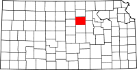 | |
| CDP | ||
| Unincorporated communities | ||