Molenwaard
| Molenwaard | |||
|---|---|---|---|
| Municipality | |||
|
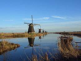
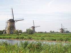
Kinderdijk wind mills | |||
| |||
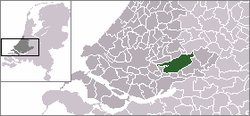 Location in South Holland | |||
| Coordinates: 51°52′N 4°47′E / 51.867°N 4.783°ECoordinates: 51°52′N 4°47′E / 51.867°N 4.783°E | |||
| Country | Netherlands | ||
| Province | South Holland | ||
| Established | 1 January 2013[1] | ||
| Government[2] | |||
| • Body | Municipal council | ||
| • Mayor | Dirk van der Borg (CDA) | ||
| Area[3] | |||
| • Total | 126.47 km2 (48.83 sq mi) | ||
| • Land | 118.29 km2 (45.67 sq mi) | ||
| • Water | 8.18 km2 (3.16 sq mi) | ||
| Elevation[4] | −1 m (−3 ft) | ||
| Population (May 2014)[5] | |||
| • Total | 28,986 | ||
| • Density | 245/km2 (630/sq mi) | ||
| Time zone | CET (UTC+1) | ||
| • Summer (DST) | CEST (UTC+2) | ||
| Postcode | 2957–2977 | ||
| Area code | 0184 | ||
| Website |
www | ||


Molenwaard [6] is a municipality in the western Netherlands, in the southeastern part of the province of South Holland, and the northwestern part of the region of Alblasserwaard. It has been the result of a merger of the municipalities of Graafstroom, Liesveld, and Nieuw-Lekkerland on 1 January 2013. Molenwaard has about 29,000 inhabitants and an area of about 126 km2 (49 sq mi). Biggest places are Bleskensgraaf, Groot-Ammers, and Nieuw-Lekkerland.
The municipality of Molenwaard lies about 1.5 m below sea level. It is bordered by the Lek river in the north and the Noord river in the west (just a small part). On its area flows the Graafstroom or Alblas river.
Molenwaard can be characterized as a landscape of polders existing of vast pastures traversed by ditches and canals, like the Groote- of Achterwaterschap, and the Ammersche Boezem. In the outermost northwest one can find the famous windmills of Kinderdijk.
From a churchly point of view the municipality belongs to the Bible Belt, with as outcome the dominating of the Christian parties in politics.
Localities
Molenwaard consists of the following settlements:
Topography
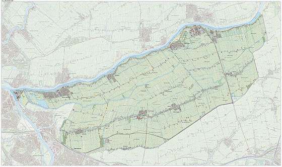
Dutch Topographic map of the municipality of Molenwaard, June 2015
Politics
The municipal council of Molenwaard consists of 21 seats, which are divided as follows:
| Municipal council seats | |||||||||||||||
|---|---|---|---|---|---|---|---|---|---|---|---|---|---|---|---|
| Party | 2013 | ||||||||||||||
| Reformed Political Party (SGP) | 5 | ||||||||||||||
| Christian Democratic Appeal (CDA) | 5 | ||||||||||||||
| ChristianUnion (CU) | 4 | ||||||||||||||
| Labour Party (PvdA) | 3 | ||||||||||||||
| Gemeentebelangen Molenwaard | 2 | ||||||||||||||
| People's Party for Freedom and Democracy (VVD) | 2 | ||||||||||||||
| Total | 21 | ||||||||||||||
References
- ↑ "Gemeentelijke indeling op 1 januari 2013" [Municipal divisions on 1 January 2013]. cbs.nl (in Dutch). CBS. Retrieved 14 August 2013.
- ↑ "College Molenwaard" [Molenwaard board] (in Dutch). Gemeente Molenwaard. Retrieved 14 August 2013.
- ↑ "Kerncijfers wijken en buurten" [Key figures for neighbourhoods]. CBS Statline (in Dutch). CBS. 2 July 2013. Retrieved 12 March 2014.
- ↑ "Postcodetool for 2971VR". Actueel Hoogtebestand Nederland (in Dutch). Het Waterschapshuis. Retrieved 14 August 2013.
- ↑ "Bevolkingsontwikkeling; regio per maand" [Population growth; regions per month]. CBS Statline (in Dutch). CBS. 26 June 2014. Retrieved 24 July 2014.
- ↑ Molenwaard is derived from 'molen' (mill) and 'waard' (flat riverland). The flat municipality of Molenwaard consists of a lot of windmills.
External links
| Wikimedia Commons has media related to Molenwaard. |
- (Dutch) Official website
 |
Nederlek / Lek Ridderkerk / Noord |
Bergambacht, Schoonhoven Lek |
Lek / Lopik (UT) | |
| Alblasserdam | |
Zederik | ||
| ||||
| | ||||
| Papendrecht | Sliedrecht, Hardinxveld-Giessendam | Giessenlanden |
