Monreal, Masbate
| Monreal | |
|---|---|
| Municipality | |
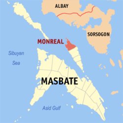 Map of Masbate with Monreal highlighted | |
.svg.png) Monreal Location within the Philippines | |
| Coordinates: 12°38′N 123°40′E / 12.633°N 123.667°ECoordinates: 12°38′N 123°40′E / 12.633°N 123.667°E | |
| Country | Philippines |
| Region | Bicol (Region V) |
| Province | Masbate |
| District | 1st district |
| Barangays | 11 |
| Government[1] | |
| • Mayor | Ben G. Espiloy |
| • Vice-mayor | Romeo L. Grona |
| Area[2] | |
| • Total | 128.67 km2 (49.68 sq mi) |
| Population (2010)[3] | |
| • Total | 25,366 |
| • Density | 200/km2 (510/sq mi) |
| Time zone | PST (UTC+8) |
| Zip Code | 5418 |
| Dialing code | 56 |
Monreal is a fourth class municipality in the province of Masbate, Philippines. It is located on the northern part of Ticao Island. According to the 2010 census, it has a population of 25,366 people.[3]
Barangays
Monreal is politically subdivided into 11 barangays.[2]
- Cantorna
- Famosa
- Macarthur
- Maglambong
- Morocborocan
- Poblacion
- Guinhadap
- Real
- Rizal
- Santo Niño
- Togoron
Demographics
| Population census of Monreal | ||
|---|---|---|
| Year | Pop. | ±% p.a. |
| 1990 | 18,796 | — |
| 1995 | 18,775 | −0.02% |
| 2000 | 19,832 | +1.18% |
| 2007 | 21,693 | +1.24% |
| 2010 | 25,366 | +5.86% |
| Source: National Statistics Office[3][4] | ||
Economy
Monreal's local economy is based on fishing. A local conservation effort to protect the environment lead to the development of tourism industry in the municipality. The Halea Island Retreat and Nature Park is the number one attraction for tourists both local and foreign, creating employment opportunities for the local folks and generating revenues for the local government in terms of taxes.
References
- ↑ "Municipalities". Quezon City, Philippines: Department of the Interior and Local Government. Retrieved 20 January 2013.
- 1 2 "Province: MASBATE". PSGC Interactive. Makati City, Philippines: National Statistical Coordination Board. Retrieved 20 January 2013.
- 1 2 3 "Total Population by Province, City, Municipality and Barangay: as of May 1, 2010" (PDF). 2010 Census of Population and Housing. National Statistics Office. Retrieved 20 January 2013.
- ↑ "Province of Masbate". Municipality Population Data. LWUA Research Division. Retrieved 23 July 2013.
External links
- Philippine Standard Geographic Code
- Philippine Census Information
- Local Governance Performance Management System
 |
Claveria / Sibuyan Sea | Pilar, Sorsogon Ticao Pass |
| |
| Aroroy / Sibuyan Sea | |
Ticao Pass / Bulan, Sorsogon | ||
| ||||
| | ||||
| Baleno / Masbate Pass | San Jacinto |
Masbate City (capital) | |
| Municipalities | |
| Component city | |
This article is issued from Wikipedia - version of the 10/27/2016. The text is available under the Creative Commons Attribution/Share Alike but additional terms may apply for the media files.