Montpothier
| Montpothier | |
|---|---|
|
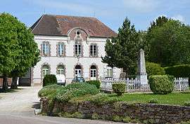
Town hall | |
 Montpothier | |
|
Location within Grand Est region  Montpothier | |
| Coordinates: 48°34′24″N 3°31′10″E / 48.5733°N 3.5194°ECoordinates: 48°34′24″N 3°31′10″E / 48.5733°N 3.5194°E | |
| Country | France |
| Region | Grand Est |
| Department | Aube |
| Arrondissement | Nogent-sur-Seine |
| Canton | Villenauxe-la-Grande |
| Intercommunality | Nogentais |
| Government | |
| • Mayor (2008–2014) | Jean Vignot |
| Area1 | 7.72 km2 (2.98 sq mi) |
| Population (2008)2 | 319 |
| • Density | 41/km2 (110/sq mi) |
| Time zone | CET (UTC+1) |
| • Summer (DST) | CEST (UTC+2) |
| INSEE/Postal code | 10254 / 10400 |
|
1 French Land Register data, which excludes lakes, ponds, glaciers > 1 km² (0.386 sq mi or 247 acres) and river estuaries. 2 Population without double counting: residents of multiple communes (e.g., students and military personnel) only counted once. | |
Montpothier is a commune in the Aube department in north-central France.
Population
| Historical population | ||
|---|---|---|
| Year | Pop. | ±% |
| 1962 | 173 | — |
| 1968 | 199 | +15.0% |
| 1975 | 209 | +5.0% |
| 1982 | 218 | +4.3% |
| 1990 | 225 | +3.2% |
| 1999 | 238 | +5.8% |
| 2008 | 319 | +34.0% |
See also
References
| Wikimedia Commons has media related to Montpothier. |
This article is issued from Wikipedia - version of the 2/22/2013. The text is available under the Creative Commons Attribution/Share Alike but additional terms may apply for the media files.