Argançon
| Argançon | |
|---|---|
|
View of Argançon from "Nigloland" | |
 Argançon | |
|
Location within Grand Est region  Argançon | |
| Coordinates: 48°15′14″N 4°36′16″E / 48.2539°N 4.6044°ECoordinates: 48°15′14″N 4°36′16″E / 48.2539°N 4.6044°E | |
| Country | France |
| Region | Grand Est |
| Department | Aube |
| Arrondissement | Bar-sur-Aube |
| Canton | Vendeuvre-sur-Barse |
| Intercommunality | Rivières |
| Government | |
| • Mayor (2008–2020) | Rémi Tournemeulle |
| Area1 | 8.2 km2 (3.2 sq mi) |
| Population (2009)2 | 101 |
| • Density | 12/km2 (32/sq mi) |
| Time zone | CET (UTC+1) |
| • Summer (DST) | CEST (UTC+2) |
| INSEE/Postal code | 10008 / 10140 |
|
1 French Land Register data, which excludes lakes, ponds, glaciers > 1 km² (0.386 sq mi or 247 acres) and river estuaries. 2 Population without double counting: residents of multiple communes (e.g., students and military personnel) only counted once. | |

Argançon is a French commune in the Aube department in the Grand Est region of north-central France.
Geography
Argançon is located some 8 km east by north-east of Vendeuvre-sur-Barse and 8 km north-west of Bar-sur-Aube in the Orient Forest Regional Natural Park. Access to the commune is by highway D619 from Dolancourt in the north-east through the north of the commune to Magny-Fouchard in the west. Access to the village is by the D44 from Dolancourt passing through the village and continuing south to Spoy. There is also the D144 road from the village to the hamlet of Le Chanet in the north of the commune. Two thirds of the commune is farmland with the rest heavily forested in the east and the south.[1]
The Landion river flows through the commune from south to north passing through the village and continuing north to join the Aube just north of Dolancourt.[1]
Neighbouring communes and villages[1]
 |
Vauchonvilliers | Jessains | Dolancourt | |
| Magny-Fouchard | |
Ailleville | ||
| ||||
| | ||||
| Spoy | Proverville |
Administration
List of Successive Mayors[2]
| From | To | Name | Party | Position |
|---|---|---|---|---|
| 1857 | Jouy-Jeanson | |||
| 2001 | 2020 | Remi Tournemeulle |
(Not all data is known)
Demography
In 2009 the commune had 101 inhabitants. The evolution of the number of inhabitants is known from the population censuses conducted in the commune since 1793. From the 21st century, a census of communes with fewer than 10,000 inhabitants is held every five years, unlike larger towns that have a sample survey every year.[Note 1]
| 1793 | 1800 | 1806 | 1821 | 1831 | 1836 | 1841 | 1846 | 1851 |
|---|---|---|---|---|---|---|---|---|
| 295 | 284 | 270 | 307 | 324 | 375 | 382 | 415 | 411 |
| 1856 | 1861 | 1866 | 1872 | 1876 | 1881 | 1886 | 1891 | 1896 |
|---|---|---|---|---|---|---|---|---|
| 394 | 407 | 395 | 373 | 329 | 312 | 303 | 309 | 245 |
| 1901 | 1906 | 1911 | 1921 | 1926 | 1931 | 1936 | 1946 | 1954 |
|---|---|---|---|---|---|---|---|---|
| 239 | 212 | 187 | 174 | 170 | 169 | 153 | 151 | 133 |
| 1962 | 1968 | 1975 | 1982 | 1990 | 1999 | 2006 | 2009 | - |
|---|---|---|---|---|---|---|---|---|
| 133 | 130 | 135 | 118 | 117 | 113 | - | 101 | - |
Sources : Ldh/EHESS/Cassini until 1962, INSEE database from 1968 (population without double counting and municipal population from 2006)

Sites and monuments
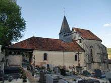
The Church of Saint-Pierre-ès-Liens has a Romanesque nave and a sanctuary rebuilt in the 16th century.[3] It contains many items that are registered as historical objects:
- The Tombstone of Jean de la Salle (1649)
 [4]
[4] - The Tombstone of Charles le Roux (1681)[5]
- A Tombstone (disappeared) (1655)[6]
- A Bust (16th century)[7]
- A Monstrance with box (19th century)[8]
- 2 Ciboriums (19th century)[9]
- Chalices and Patens (19th century)[10]
- A Processional Staff: Saint Nicolas (19th century)[11]
- A Processional Staff: Saint Peter (18th century)[12]
- A Processional Staff: Saint Éloi (19th century)[13]
- An Altar and Retable of Saint Nicolas (18th century)[14]
- A Bronze Bell (1779)[15]
- The Furniture in the Church[16]
See also
External links
- Argançon on the National Geographic Institute website (French)
- Argançon on Lion1906
- Argançon on Google Maps
- Argançon on Géoportail, National Geographic Institute (IGN) website (French)
- Argançon on the 1750 Cassini Map
- Argançon on the INSEE website (French)
- INSEE (French)
Notes and references
Notes
- ↑ At the beginning of the 21st century, the methods of identification have been modified by Law No. 2002-276 of 27 February 2002, the so-called "law of local democracy" and in particular Title V "census operations" allows, after a transitional period running from 2004 to 2008, the annual publication of the legal population of the different French administrative districts. For communes with a population greater than 10,000 inhabitants, a sample survey is conducted annually, the entire territory of these communes is taken into account at the end of the period of five years. The first "legal population" after 1999 under this new law came into force on 1 January 2009 and was based on the census of 2006.
References
- 1 2 3 Google Maps
- ↑ List of Mayors of France (French)
- ↑ Marguerite Beau: Essay on the religious architecture of Aube southern Champagne including Troyes (1991) (French)
- ↑ Ministry of Culture, Palissy PM10000037 Tombstone of Jean de la Salle
(French)

- ↑ Ministry of Culture, Palissy IM10009886 Tombstone of Charles le Roux
(French)
- ↑ Ministry of Culture, Palissy IM10009883 Tombstone (French)
- ↑ Ministry of Culture, Palissy IM10010119 Bust
(French)
- ↑ Ministry of Culture, Palissy IM10009946 Monstrance with box
(French)
- ↑ Ministry of Culture, Palissy IM10009945
IM10009941 Ciboriums
(French)
- ↑ Ministry of Culture, Palissy IM10009944 Chalice with Paten
IM10009943 Paten
IM10009942 Chalice
(French)
- ↑ Ministry of Culture, Palissy IM10009940 Processional Staff: Saint Nicolas
(French)
- ↑ Ministry of Culture, Palissy IM10009893 Processional Staff: Saint Peter
(French)
- ↑ Ministry of Culture, Palissy IM10009857 Processional Staff: Saint Éloi
(French)
- ↑ Ministry of Culture, Palissy IM10009939 Altar and Retable of Saint Nicolas
(French)
- ↑ Ministry of Culture, Palissy IM10009938 Bronze Bell
(French)
- ↑ Ministry of Culture, Palissy IM10010094 Furniture in the Church (French)
| Wikimedia Commons has media related to Argançon. |