Bar-sur-Aube
| Bar-sur-Aube | ||
|---|---|---|
|
Bar-sur-Aube | ||
| ||
 Bar-sur-Aube | ||
|
Location within Grand Est region  Bar-sur-Aube | ||
| Coordinates: 48°16′N 4°43′E / 48.27°N 4.72°ECoordinates: 48°16′N 4°43′E / 48.27°N 4.72°E | ||
| Country | France | |
| Region | Grand Est | |
| Department | Aube | |
| Arrondissement | Bar-sur-Aube | |
| Canton | Bar-sur-Aube | |
| Intercommunality | Bar-sur-Aube | |
| Government | ||
| • Mayor (2014–2020) | Philippe Borde | |
| Area1 | 16.27 km2 (6.28 sq mi) | |
| Population (2010)2 | 5,259 | |
| • Density | 320/km2 (840/sq mi) | |
| Time zone | CET (UTC+1) | |
| • Summer (DST) | CEST (UTC+2) | |
| INSEE/Postal code | 10033 / 10200 | |
| Elevation |
156–348 m (512–1,142 ft) (avg. 166 m or 545 ft) | |
|
1 French Land Register data, which excludes lakes, ponds, glaciers > 1 km² (0.386 sq mi or 247 acres) and river estuaries. 2 Population without double counting: residents of multiple communes (e.g., students and military personnel) only counted once. | ||
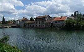
Bar-sur-Aube (French: [baʁ syʁ ob]) is a French commune and a sub-prefecture in the Aube department in the Grand Est region of France.[1]
Surrounded by hills and Champagne vineyards, the city is traversed by the river Aube, from which it derives its name.
The inhabitants of the commune are known as Baralbins or Baralbines and Barsuraubois or Barsurauboises.[2]
The commune has been awarded three flowers by the National Council of Towns and Villages in Bloom in the Competition of cities and villages in Bloom.[3]
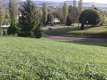
Geography
Bar-sur-Aube is located some 30 km west by north-west of Chaumont and 25 km south-east of Brienne-le-Château. Access to the commune is by the D619 road from Ailleville in the north-west which passes through the centre of the commune and the town before continuing east to Lignol-le-Château. The D396 branches off the D619 south-east of the town and goes south to Juvancourt. The D4 goes south-west from the town to Couvignon. The D13 comes from Fontaine in the south and passes through the town before continuing north-east to Colombé-la-Fosse. The D384 goes north to Ville-sur-Terre while the D73 branches off it in the town and goes to Arrentières. in the north. The TER Champagne-Ardenne Troyes to Chalindrey railway passes through the commune coming from Vendeuvre-sur-Barse to the west to Bricon in the south-east with a station in the town. With a substantial urban area in the west and some forest in the south the commune is mostly farmland.[4][5]

The Aube river flows through the commune and the town from south-east to north-west continuing to eventually join the Seine at Marcilly-sur-Seine. The Bresse also flows through the commune coming from the north-east and forming a small part of the northern border before joining the Aube at the north-western tip of the commune.[4][5]
Mapping
A list of online mapping systems can be displayed by clicking on the coordinates (latitude and longitude) in the top right hand corner of this article.
Neighbouring communes and villages
 |
Ailleville | Arrentières | | |
| Proverville | |
Voigny | ||
| ||||
| | ||||
| Couvignon | Fontaine | Lignol-le-Château |
Toponymy
The area was attested in the form castro barro in the 7th century and Barri villa in 932.
Bar comes from a Gallic word meaning "summit" and is perhaps even older (pre-Gallic).[6]
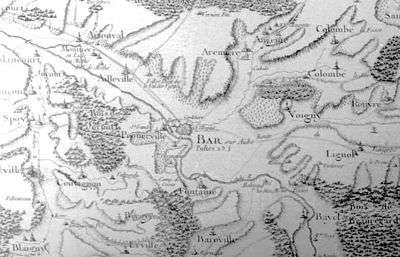
Bar-sur-Aube appears as Bar sur Aube on the 1750 Cassini Map[7] and the same on the 1790 version.[8]
History
Ancient times

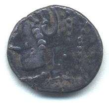
The existence of Bar-sur-Aube goes back to ancient times. There are remains of an oppidum from the Iron Age. A coin with the image of a horse in the name of Togirix (Chief of the Lingones) was discovered on the Sainte Germaine hill.
In Roman times the town appeared on the Tabula Peutingeriana under the name of Segessera. Some remains from the 1st to the 4th century including villas have been discovered in the town and surrounding areas. Segessera seemed to have existed from the Roman period to the first Lyonnais in the territory of the Lingones.
The city was devastated by Attila. After the division of the kingdom of Clovis by his son the town became part of Austrasia.
Middle Ages
Under Charles the Bald several varieties of coins were issued with the name of the city on the reverse. During the period of the Counts of Champagne the town was of great importance with the Champagne fairs where merchants from Flanders and Italy traded Oriental spices and silk for textiles and raw materials from the north of Europe in mid-February and mid-April. The town was then joined to the crown of France. In 1318 Philip V the Tall sold the town to Jacques de Croÿ, residents bought it themselves to ensure that the king could no longer sell or alienate the lands.
Modern and contemporary eras
When Charles V besieged Saint-Dizier the inhabitants of nearby villages came under his protection. The town suffered a long plague in 1636 which led to the end of the fair. In 1862 the fortifications were demolished and the boulevard du tour put in their place.
The French Revolution was well received in the commune and the convents disappeared. It became the chief town of the district from 1790 to 1800.
Bar-sur-Aube was the scene of a battle to the end of the Napoleonic era on 27 February 1814.
In 1911 the Champagne riots of the Aube winegrowers and the Marnais traders to keep the vineyards in the Appellation d'origine contrôlée of "Champagne".
Heraldry
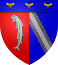 |
Blazon: Parti per pale, at 1 Gules, a barbel Argent; at 2 Azure, a bend argent potent counter potent Or; in chief Azure chrged with 3 bees flying of Or. |
Administration
List of Successive Mayors[9][10]
| From | To | Name | Party | Position |
|---|---|---|---|---|
| 1789 | Claude Laurent Bourgeois de Jessaint | |||
| 1857 | Vernand | |||
| 1943 | Arthur Bureau | |||
| 1943 | 1947 | Léon Chevillotte | ||
| 1947 | 1959 | Maurice Véchin | ||
| 1959 | 1964 | Henry Supper | Printer | |
| 1964 | 1965 | Roger Rubaud (interim) | Retired | |
| 1965 | 1971 | Claude Pertat | Commercial agent | |
| 1971 | 2001 | Jean-Pierre Davot | Trader | |
| 2001 | 2008 | Jean-François Leroux | ||
| 2008 | 2014 | René Gaudot | PRG | |
| 2014 | 2020 | Philippe Borde | UMP |
(Not all data is known)
Twinning
Bar-sur-Aube has twinning associations with:[11]
 Gernsheim (Germany) since 1976.
Demography
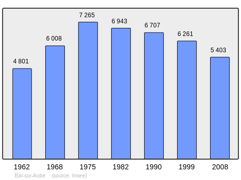
In 2010 the commune had 5259 inhabitants. The evolution of the number of inhabitants is known from the population censuses conducted in the commune since 1793. From the 21st century, a census of communes with fewer than 10,000 inhabitants is held every five years, unlike larger communes that have a sample survey every year.[Note 1]
| 1793 | 1800 | 1806 | 1821 | 1831 | 1836 | 1841 | 1846 | 1851 |
|---|---|---|---|---|---|---|---|---|
| 3,652 | 3,665 | 3,707 | 3,503 | 3,890 | 3,940 | 4,169 | 4,163 | 4,442 |
| 1856 | 1861 | 1866 | 1872 | 1876 | 1881 | 1886 | 1891 | 1896 |
|---|---|---|---|---|---|---|---|---|
| 4,781 | 4,727 | 4,809 | 4,453 | 4,521 | 4,579 | 4,636 | 4,342 | 4,548 |
| 1901 | 1906 | 1911 | 1921 | 1926 | 1931 | 1936 | 1946 | 1954 |
|---|---|---|---|---|---|---|---|---|
| 4,587 | 4,507 | 4,533 | 4,074 | 4,313 | 4,264 | 4,002 | 3,921 | 4,387 |
| 1962 | 1968 | 1975 | 1982 | 1990 | 1999 | 2006 | 2010 | - |
|---|---|---|---|---|---|---|---|---|
| 4,801 | 6,008 | 7,265 | 6,943 | 6,707 | 6,261 | 5,510 | 5,259 | - |
Sources : Ldh/EHESS/Cassini until 1962, INSEE database from 1968 (population without double counting and municipal population from 2006)
Education
The commune has several schools and colleges:[12]
- One public Kindergarten: Gambetta
- 3 Elementary schools:
- Saint Teresa
- Arthur Bureau Public school
- Maurice Vechin public school
- One college: the College Gaston Bachelard The college consists of 19 classes spread over 4 floors offering students with options for latin in the 5th year, Greek in the 3rd year and has the distinction of being the only college in France to have a cinema-audiovisual option. A soccer section is available for middle school and high school students.[13]
- One comprehensive school: Lycée Polyvalent Gaston Bachelard This general and technological school consists of 14 classes spread over 3 levels and offers its students the following courses: S (Scientific), L (literary), ES (economic and social) and STMG (Science and Technology manageant and management). It also offers a cinema-audiovisual option from the 2nd year. Foreign languages ??taught are German, English and Spanish. Classes are held in groups of skills not whole classes. Each year school trips are organized to Germany, Scotland, and Spain. In 2013 an exchange with students from Ashburn (United States) began. The French students went in February and US students came in 2014. The vocational high school consists of 6 classes spread over 3 floors and offers its students courses in trade and electrical engineering.[14]
Sports
There are numerous sports clubs in Bar-sur-Aube:[15]
| Activity | Club |
|---|---|
| Billiards | Billiard Club Baralbin |
| Diving | Club Nautique Baralbin |
| Cycling | Cyclo Club Baralbin, Étoile Cycliste Baralbine |
| Football | BFC vétéran, OS Luisadas, Bar Football Club |
| Gym | Gymnastic Volontaire Bar. Gym des Nin's, Jeune Garde de Bar-sur-Aube, La Concorde |
| Hang-gliding / Para-gliding | Les Ailes de Sainte-Germaine |
| Table tennis, roller blades, canoe, kayaking | Maison pour Tous |
| Pétanque | Pétanque baralbine |
| Basketball | PL Basket |
| Multi-sports | Patronage laïque |
| Rhythmic Gym | G.I.R.L.S. |
| Badminton | Badminton Club Baralbin |
| Aikido | Bar-sur-Aube Aïkido |
| Athletics | Cercle Athlétique Bar-Bayel |
| Fencing | Cercle d'Escrime Baralbin |
| Archery and Shooting | Diana Sport |
| Judo | Judo Club Baralbin |
| Thai Boxing | Muay thai pahuyouth |
| Handball | PL Handball |
| Mountain Climbing | Roc Altitude |
| Karate | Shotokan Karaté Do |
| Swimming | Stade Nautique Baralbin |
| Tennis | Tennis Club Baralbin |
Economy

The commune has a branch of the Chamber of Commerce and Industry of Troyes and Aube.
Industry
- The hemp industry is highly developed in Bar-sur-Aube and has been growing steadily for several years.
- Furniture Manufacturing: Dumeste (Cauval Industries Group)
- Metal processing (forging, machining) for aerospace, armaments, agricultural machinery, medicine (prosthetics), etc. Manoir Aerospace.
Agriculture
Bar-sur-Aube, is the largest French producer of straw hemp (125 tons per day) and many hemp products are manufactured in the commune. Around the town there are many vineyards specializing in champagne.
Culture and heritage

Guided tours of the town are organised on request by the Office of Tourism.
The commune contains a very large number of objects that are registered as historical objects - mainly in the Church of Saint Peter but many others in different locations. To see a complete list with linbks to descriptions (in French) and photos click here.
Civil heritage
- The Covered Market
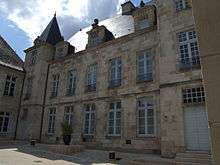
- The former Hotel de Surmont (now the Post Office)
- The Marcasselles Mill
The commune has many buildings and sites that are registered as historical monuments:
- A House at 33 Rue d'Aube (16th century)
 [16]
[16] - A House at 44 Rue d'Aube (16th century)[17]
- The Petit Clairvaux Storehouse at 24 Rue Beugnot (12th century)[18]
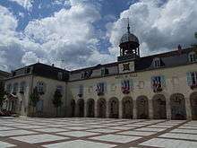
- An Ursuline Convent at Place Carnot (17th century)[19] (now the Town Hall)
- The Doré and son woollen mill at 1bis Rue Chenot (20th century)[20]
- The René Thiéblemont Carpentry factory at Route de Fontaine (20th century)[21]
- The Thuillier Stamping Plant at Avenue du Général Leclerc (20th century)[22]
- The Perfor metalwork factory at 32 avenue du Général Leclerc (20th century)[23]
- The Chevallier Foundry at 30 avenue du Général Leclerc (20th century)[24]
- The Henry Comte Sawmill at rue du Général de Gaulle (20th century)[25]
- A Building at 79 Rue Nationale (16th century)[26]
- A Flourmill at 25 boulevard de la République (18th century)[27]
- A Small Flourmill at 21 boulevard de la République (18th century)[28]
- A Building at 1 petite rue Saint-Pierre (15th century)[29]
- A Hotel at 15, 17 rue Saint-Pierre; 4 rue Delaunay (15th century)[30] (now a Museum and Library)
- A Building at 4 rue Saint-Pierre (18th century)[31]
- The Joseph de Bucy Diesel motor works at rue du Sommerard (20th century)[32]
- The Breton-Cordier Tannery at 2 rue des Tanneries (19th century)[33]
- The Three Towers House at 9 rue des Trois-Tours (16th century)[34]
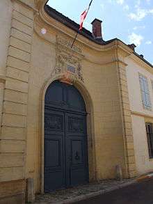
- The Sub-Prefecture (18th century)[35]
- An Oppidum (Iron Age)[36]
Religious heritage
- The Chapel of Saint John from the Knights Templar then the Knights Hospitaller.
- The Chapel of Sainte-Germaine
The commune has three religious buildings that are registered as historical monuments:
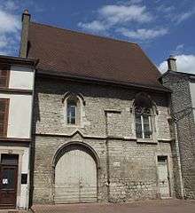
- A Priory (16th century)[37]
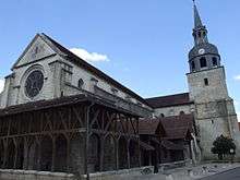
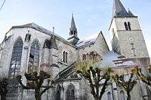
- The Church of Saint Peter (16th century)[38]
- The Church of Saint Maclou (12th century)[39]
Festivals
- Cheese festival in June
- Eurythmies Festival, late June.
- Festival "JazzàBar" early September
- A Market every Saturday morning under the covered market, in the Town Hall Square, and in the Rue Nationale
- Local Palm Festival
- Medieval Fair, the first weekend in September
- Gourmet Champagne Promenade in May
Notable people linked to the commune
- Sainte Germaine, martyr in 451, decapitated on the order of Attila
- Jean-François Armand:[40] (born 24 June 1789 - Bar-sur-Aube, died 27 March 1883 - Gravières), École polytechnique, Corps des Ponts, MP for Aube (1837-1848);
- Bertrand de Bar-sur-Aube, troubador of the 13th century.
- Étienne d’Acier, poet, disciple of Pierre de Ronsard, 16th century.
- Gaston Bachelard, philosopher (1884-1962).
- Armand Beauvais, rural painter (1840-1911).
- Jacques Claude Beugnot, Count of Beugnot (1761-1835).
- Maurice Emmanuel, musicologist and French composer born in Bar-sur-Aube in 1862 and died in Paris in 1938.
- Albert Gabriel, architect, specialist on Anatolia, professor in the College of France and the University of Istanbul (1883-1972).
- Jeanne de Valois-Saint-Rémy, Countess of the Motte, instigator of the Affair of the Diamond Necklace.
- Marc Rétaux de Villette, forger, implicated in the Affair of the Diamond Necklace
- Marinette Pichon, born on 26 November 1975 in Bar-sur-Aube, former French footballer who played for FCF Juvisy and in the France women's national football team (to 2006, 112 caps and 82 goals).
- Gaston Cheq, saviour of the Aube vineyards, born on 14 January 1866 in Bar-sur-Aube.
- Alexandre Du Sommerard, archaeologist born in Bar-sur-Aube in 1779, died at Saint-Cloud on 19 August 1842, founder of the Musée de Cluny (Paris).
- Charlemagne de Maupas, prefect of police in Paris, one of the architects of the French coup d'état of 1851.
- Jules Franceschi, French Sculptor of nature (born in Bar-sur-Aube on 11 January 1825, died in Paris on 1 September 1893)
See also
- Communes of the Aube department
- Bertrand de Bar-sur-Aube - medieval French poet
External links
Notes and references
Notes
- ↑ At the beginning of the 21st century, the methods of identification have been modified by Law No. 2002-276 of 27 February 2002, the so-called "law of local democracy" and in particular Title V "census operations" allows, after a transitional period running from 2004 to 2008, the annual publication of the legal population of the different French administrative districts. For communes with a population greater than 10,000 inhabitants, a sample survey is conducted annually and the entire territory of these communes is taken into account at the end of the period of five years. The first "legal population" after 1999 under this new law came into force on 1 January 2009 and was based on the census of 2006.
References
- ↑ Bar-sur-Aube on Lion1906
- ↑ Inhabitants of Aube (French)
- ↑ Competition for Towns and Villages in Bloom website Archived December 10, 2014, at the Wayback Machine. (French)
- 1 2 3 Bar-sur-Aube on Google Maps
- 1 2 Bar-sur-Aube on the Géoportail from National Geographic Institute (IGN) website (French)
- ↑ Pierre Gastal, Our Celtic roots, éd. Désiris, 2013, p. 120-121. (French)
- ↑ Bar sur Aube on the 1750 Cassini Map
- ↑ Bar sur Aube on the 1790 Cassini Map
- ↑ List of Mayors of France (French)
- ↑ Seven Mayors since 1947 (French)
- ↑ National Commission for Decentralised cooperation (French)
- ↑ Schools in Bar-sur-Aube (French)
- ↑ College Gaston Bachelard (French)
- ↑ Lycée Gaston Bachelard Courses (French)
- ↑ List of Sports Clubs in Bar-sur-Aube 2014 (French)
- ↑ Ministry of Culture, Mérimée PA00078038 House at 33 Rue d'Aube (French)
- ↑ Ministry of Culture, Mérimée PA00078039 House at 44 Rue d'Aube (French)
- ↑ Ministry of Culture, Mérimée PA00078033 Petit Clairvaux Storehouse (French)
- ↑ Ministry of Culture, Mérimée PA00078029 Ursuline Convent at Place Carnot (French)
- ↑ Ministry of Culture, Mérimée IA10000081 Doré and son factory (French)
- ↑ Ministry of Culture, Mérimée IA10000059 René Thiéblemont Carpentry factory (French)
- ↑ Ministry of Culture, Mérimée IA10000001 Thuillier Stamping Plant
 (French)
 - ↑ Ministry of Culture, Mérimée IA10000002 Perfor metalwork factory (French)
- ↑ Ministry of Culture, Mérimée IA10000056 Chevallier Foundry (French)
- ↑ Ministry of Culture, Mérimée IA10000058 Henry Comte Sawmill (French)
- ↑ Ministry of Culture, Mérimée PA00078034 Building at 79 Rue Nationale (French)
- ↑ Ministry of Culture, Mérimée IA10000062 Flourmill (French)
- ↑ Ministry of Culture, Mérimée IA10000061 Small Flourmill (French)
- ↑ Ministry of Culture, Mérimée PA00078035 Building at 1 petite rue Saint-Pierre (French)
- ↑ Ministry of Culture, Mérimée PA00078032 Hotel at 15, 17 rue Saint-Pierre; 4 rue Delaunay (French)
- ↑ Ministry of Culture, Mérimée PA00078036 Building at 4 rue Saint-Pierre (French)
- ↑ Ministry of Culture, Mérimée IA10000057 Joseph de Bucy Diesel motor works (French)
- ↑ Ministry of Culture, Mérimée IA10000060 Breton-Cordier Tannery (French)
- ↑ Ministry of Culture, Mérimée PA00078037 Three Towers House (French)
- ↑ Ministry of Culture, Mérimée PA00078042 Sub-prefecture (French)
- ↑ Ministry of Culture, Mérimée PA00078040 Oppidum (French)
- ↑ Ministry of Culture, Mérimée PA00078041 Priory (French)
- ↑ Ministry of Culture, Mérimée PA00078031 Church of Saint Peter (French)
- ↑ Ministry of Culture, Mérimée PA00078030 Church of Saint Maclou (French)
- ↑ Armand (Jean-Francois) in Robert and Cougny, Dictionary of French parliamentarians, 1889 (French)
| Wikimedia Commons has media related to Bar-sur-Aube. |
| Wikisource has the text of the 1911 Encyclopædia Britannica article Bar-sur-Aube. |