Moosup Valley State Park Trail
| Moosup Valley State Park Trail | |
| Connecticut State Park | |
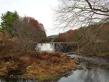 View north of the Moosup River's Brunswick Dam and the North Main Street (CT Route 14) bridge from the Moosup Valley State Park Trail in Plainfield, Connecticut. | |
| Country | |
|---|---|
| State | |
| County | Windham |
| Towns | Plainfield, Sterling |
| Coordinates | 41°42′0″N 71°54′0″W / 41.70000°N 71.90000°WCoordinates: 41°42′0″N 71°54′0″W / 41.70000°N 71.90000°W |
| Area | 63 acres (25 ha) |
| Abandoned to state | 1987 |
| Management | Connecticut Department of Energy and Environmental Protection |
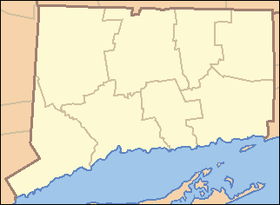 Location in Connecticut | |
| Website: Moosup Valley State Park Trail | |
The Moosup Valley State Park Trail is a rail trail located on the railbed of a former New York, New Haven and Hartford Railroad line in the New England towns of Plainfield[1] and Sterling[2] in Windham County, Connecticut.[3] The line ran from 1898 until 1968.[4] The rail line was abandoned in the late 1960s, and was designated by the state as a multi-use trail in 1987. The trail is owned and operated by the Connecticut Department of Energy and Environmental Protection.
It runs for approximately 6 miles (9.7 km) from the center of the village of Moosup (41°42′47″N 71°52′52″W / 41.713°N 71.881°W) to the Rhode Island state line (41°41′44″N 71°47′19″W / 41.6956°N 71.7887°W), where the trail continues into Rhode Island as the Coventry Greenway.[4] The Moosup Valley Trail, together with the Quinebaug River Trail and the Air Line Trail, is "a critical link" in the Hartford to Providence section of the planned East Coast Greenway.[5]
Current trail conditions
The trail is a work in progress. It is open to the public for its entire length, and all major gaps and obstructions have been removed or filled in, but many sections are rough and unimproved.
The following is a section-by-section description of current trail conditions.
Trailhead at Route 14 in Moosup to Barber Hill Road, Plainfield: This section of trail is completed. It has trailhead parking and starts by crossing the Moosup River on a refurbished railroad bridge. The trail is paved with a smooth, wide asphalt surface for this section. Most of this part was completed as part of the project to replace the Barber Hill Road bridge over the Moosup River.
Barber Hill Road, Plainfield to bridge over Providence Road, Sterling: This section of trail is mostly undeveloped. It was cleared and graded several years ago, and has a dirt, rocky surface. It is suitable for horses and mountain bikes, but not for street bikes. The bridge over the Moosup River in Sterling was repaired and given a new deck for trail use.
Bridge over Providence Road, Sterling to Spring Lake Road, Sterling: A brand new bridge was recently completed to carry the trail over Providence Road. This bridge replaces the original rail bridge which was removed when the rail line was first abandoned. As part of the new bridge project, a 3/4 mile section of trail from the new bridge east to Spring Lake Road was completed and paved with a wide, smooth asphalt surface. This is the first section in Sterling to be officially completed and the new bridge removes the last physical obstacle along the trail's route.
Spring Lake Road, Sterling to RI State Line: This section is open but is undeveloped. It has a rough dirt surface and is best traveled on foot or mountain bike.
The trail continues into Rhode Island as the Trestle Trail, a multi-use trail that is operated by the Rhode Island Department of Environmental Management.
Crossings
The whole trail is in Windham County, Connecticut.
| Town | Carrying | Notes | Coordinates |
|---|---|---|---|
| Plainfield | parking area/
terminus |
41°42′46″N 71°52′52″W / 41.7129°N 71.8812°W | |
| Moosup River | river crossing | 41°42′49″N 71°52′48″W / 41.7135°N 71.8800°W | |
| River St. | 41°42′51″N 71°52′44″W / 41.7141°N 71.8790°W | ||
| Barber Hill Rd. | 41°43′02″N 71°52′07″W / 41.7171°N 71.8686°W | ||
| Brunswick Ave. | 41°42′59″N 71°51′39″W / 41.7165°N 71.8608°W | ||
| overpass | 41°43′10″N 71°51′31″W / 41.7194°N 71.8587°W | ||
| Sterling | Moosup River | 41°42′46″N 71°50′11″W / 41.7127°N 71.8364°W | |
| Main St. | 41°42′36″N 71°49′54″W / 41.7101°N 71.8316°W | ||
| Industrial Park Rd. | 41°42′33″N 71°49′45″W / 41.7091°N 71.8293°W | ||
| 41°42′25″N 71°49′33″W / 41.7069°N 71.8257°W | |||
| Providence Rd. | underpass | 41°41′52″N 71°48′33″W / 41.6978°N 71.8093°W | |
| Spring Lake Rd. | 41°41′48″N 71°48′01″W / 41.6968°N 71.8003°W | ||
| 41°41′48″N 71°47′54″W / 41.6967°N 71.7983°W | |||
| Sterling/ | State Border |
terminus | 41°41′44″N 71°47′19″W / 41.6956°N 71.7887°W |
References
- ↑ "Plainfield: Moosup Valley State Park Trail" (PDF). Connecticut Department of Transportation. Retrieved May 7, 2014.
- ↑ "Sterling: Moosup Valley State Park Trail" (PDF). Connecticut Department of Transportation. Retrieved May 7, 2014.
- ↑ "Moosup Valley State Park Trail". State Parks and Forests. Connecticut Department of Energy and Environmental Protection. September 13, 2016. Retrieved September 28, 2016.
- 1 2 "Moosup Valley State Park Trail". TrailLink. Rails-to-Trails Conservancy. Retrieved May 7, 2014.
- ↑ "Connecticut National Recreational Trails Program Recreational Trails Plan" (PDF). Connecticut Department of Energy and Environmental Protection. September 2011. p. 4. Retrieved May 7, 2014.
External links
- Moosup Valley State Park Trail Connecticut Department of Energy and Environmental Protection
- Moosup Valley State Park Trail Map Connecticut Department of Energy and Environmental Protection
| ||