Mount Bushnell State Park
| Mount Bushnell State Park | |
| Connecticut State Park | |
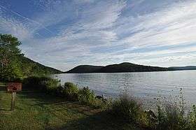 Mount Bushnell across the waters of Lake Waramaug | |
| Country | |
|---|---|
| State | |
| County | Litchfield |
| Town | Washington |
| Elevation | 1,178 ft (359 m) [1] |
| Coordinates | 41°41′22″N 73°21′44″W / 41.68944°N 73.36222°WCoordinates: 41°41′22″N 73°21′44″W / 41.68944°N 73.36222°W [1] |
| Area | 214 acres (87 ha) [2] |
| Established | 1916 |
| Management | Connecticut Department of Energy and Environmental Protection |
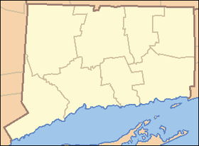 Location in Connecticut | |
| Website: Mount Bushnell State Park | |
Mount Bushnell State Park is an undeveloped public recreation area located south of Lake Waramaug in the New England town of Washington, Connecticut. The state park provides 214 acres (87 ha) for hiking.[3] The park had its genesis in the state's purchase of 70 acres in 1916.[4] It is managed by the Connecticut Department of Energy and Environmental Protection.
References
- 1 2 "Mount Bushnell State Park". Geographic Names Information System. United States Geological Survey.
- ↑ "Appendix A: List of State Parks and Forests" (PDF). State Parks and Forests: Funding. Staff Findings and Recommendations. Connecticut General Assembly. January 23, 2014. p. A-2. Retrieved September 29, 2016.
- ↑ "Mount Bushnell State Park". State Parks and Forests. Connecticut Department of Energy and Environmental Protection. Retrieved March 5, 2013.
- ↑ Report of the State Park and Forest Commission to the Governor 1916 (Report). Hartford, Conn.: State of Connecticut. December 11, 1916. p. 22. Retrieved September 29, 2016.
External links
- Mount Bushnell State Park Connecticut Department of Energy and Environmental Protection
| Wikimedia Commons has media related to Mount Bushnell State Park. |
This article is issued from Wikipedia - version of the 11/3/2016. The text is available under the Creative Commons Attribution/Share Alike but additional terms may apply for the media files.