Wyantenock State Forest
| Wyantenock State Forest | |
| Connecticut State Forest | |
| Country | |
|---|---|
| State | |
| County | Litchfield |
| Towns | Warren, Kent, Cornwall |
| Elevation | 1,355 ft (413 m) [1] |
| Coordinates | 41°46′06″N 73°23′27″W / 41.76833°N 73.39083°WCoordinates: 41°46′06″N 73°23′27″W / 41.76833°N 73.39083°W [1] |
| Area | 4,083 acres (1,652 ha) [2] |
| Established | 1925 [3] |
| Management | Connecticut Department of Energy and Environmental Protection |
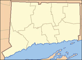 Location in Connecticut | |
| Website: Wyantenock State Forest | |
Wyantenock State Forest is a Connecticut state forest located in the towns of Warren, Kent and Cornwall. The forest consists of nine scattered parcels and was originally part of Mohawk State Forest. The forest is one of the least visited and developed state forests with little or no public access.[4]
References
- 1 2 "Wyantenock State Forest". Geographic Names Information System. United States Geological Survey.
- ↑ Legislative Program Review and Investigations Committee (January 23, 2014). "State Parks and Forests: Funding" (PDF). Staff Findings and Recommendations. Connecticut General Assembly. p. A-4. Retrieved March 20, 2014.
- ↑ "Connecticut State Forests Seedling Letterbox Series - Clues for Wyantenock State Forest". State Parks and Forests. Connecticut Department of Energy and Environmental Protection. Retrieved 2013-09-28.
- ↑ "Wyantenock State Forest". Cornwall Historical Society.
External links
- Wyantenock State Forest Connecticut Department of Energy and Environmental Protection
This article is issued from Wikipedia - version of the 6/20/2014. The text is available under the Creative Commons Attribution/Share Alike but additional terms may apply for the media files.