Carteret County, North Carolina
| Carteret County, North Carolina | ||
|---|---|---|
|
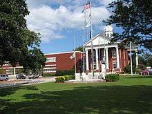
Carteret County Courthouse | ||
| ||
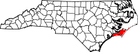 Location in the U.S. state of North Carolina | ||
 North Carolina's location in the U.S. | ||
| Founded | 1739 | |
| Named for | Sir George Carteret | |
| Seat | Beaufort | |
| Largest town | Morehead City | |
| Area | ||
| • Total | 1,341 sq mi (3,473 km2) | |
| • Land | 506 sq mi (1,311 km2) | |
| • Water | 834 sq mi (2,160 km2), 62 | |
| Population | ||
| • (2010) | 66,469 | |
| • Density | 131/sq mi (51/km²) | |
| Congressional district | 3rd | |
| Time zone | Eastern: UTC-5/-4 | |
| Website |
www | |

Coordinates: 34°44′N 76°46′W / 34.733°N 76.767°W
Carteret County is a county located in the U.S. state of North Carolina. As of the 2010 census, the population was 66,469.[1] Its county seat is Beaufort.[2] The county was created in 1722 as Carteret Precinct and gained county status in 1739.[3] It was named for Sir George Carteret, one of the 17th century English Lords Proprietor, or for his descendant and heir John Carteret, 2nd Earl Granville.
Carteret County comprises the Morehead City, NC Micropolitan Statistical Area, which is also included in the New Bern-Morehead City, NC Combined Statistical Area. Most of the county is part of the Crystal Coast.
History
The first male of English parents born in the current area of North Carolina was John Fulford. He was born in 1629 in what is now Carteret County, North Carolina. He settled in this area and died in 1729. An article dated Sept. 18, 1893, in The New Bern Daily Journal, identified Fulford's grave in a cemetery outside Beaufort, NC, in an area called the Straits, “bricked up with English brick.” In 1971 a survey by the Carteret County Historical Society found such a grave in the Fulford Cemetery off Piper Lane in Gloucester. There is an unmarked bricked up grave matching this description today.[4] One of the more profound families from Carteret County was the Dennis family. William Dennis Sr. (b.1720 d. 1800) was an extremely colorful landowner, Revolutionary War officer and overall defender of the county of Carteret. In 1747, William Dennis assisted with the successful defense of the county during the War of Jenkins' Ear (fighting against Spanish pirates). Perhaps William Dennis' greatest contribution to Carteret County was his service during the Revolutionary War. William participated in the Battle of Brandywine. At the ripe age of 60, William was a Major in the Carteret County Militia. In 1782, William assisted with driving the British from Carteret County alongside Col. John Easton. William was once an owner of the famous Hammock House. By the year 1790, William was shown as one of the largest land owners in the county. Branches of the Dennis family include the Bell's, Watson's and Pelletier's, many of whom continued to live in the area for many years to follow. Some branches of this family later migrated to both Mississippi and Texas.
Law and government
Carteret County is a member of the regional Eastern Carolina Council of Governments. It includes 16 of North Carolina's townships.
A voting machine malfunction in the county resulted in the loss of 4,438 ballots cast during early voting for the November 2, 2004 general election.[5] Since the number of lost ballots exceeded the lead held (by Steve Troxler over Britt Cobb) in the statewide race for agriculture commissioner, the State Board of Elections decided to hold a special election on January 11, 2005, open only to the 18,500 voters in the county who either failed to vote or whose votes were lost.[6][7] Both candidates filed legal challenges contesting the format of the new election.[8] On February 4, 2005, Cobb conceded the race.[9]
Military
Marine Corps Auxiliary Landing Field Bogue is located in the western section of Carteret County along Bouge Sound. It comprises an 875 acres (3.54 km2) landing field located on Bogue Sound that serves as the Marine Corps’ only East Coast site for Field Carrier Landing Practice (FCLP).[10]
Geography
According to the U.S. Census Bureau, the county has a total area of 1,341 square miles (3,470 km2), of which 506 square miles (1,310 km2) is land and 834 square miles (2,160 km2) (62%) is water.[11] It is the third-largest county in North Carolina by total area.
Adjacent counties
- Craven County (north)
- Pamlico County (north)
- Hyde County (northeast)
- Onslow County (southwest)
- Jones County (northwest)
National protected areas
Major highways
Demographics
| Historical population | |||
|---|---|---|---|
| Census | Pop. | %± | |
| 1790 | 3,734 | — | |
| 1800 | 4,399 | 17.8% | |
| 1810 | 4,823 | 9.6% | |
| 1820 | 5,609 | 16.3% | |
| 1830 | 6,597 | 17.6% | |
| 1840 | 6,591 | −0.1% | |
| 1850 | 6,939 | 5.3% | |
| 1860 | 8,186 | 18.0% | |
| 1870 | 9,010 | 10.1% | |
| 1880 | 9,784 | 8.6% | |
| 1890 | 10,825 | 10.6% | |
| 1900 | 11,811 | 9.1% | |
| 1910 | 13,776 | 16.6% | |
| 1920 | 15,384 | 11.7% | |
| 1930 | 16,900 | 9.9% | |
| 1940 | 18,284 | 8.2% | |
| 1950 | 23,059 | 26.1% | |
| 1960 | 30,940 | 34.2% | |
| 1970 | 31,603 | 2.1% | |
| 1980 | 41,092 | 30.0% | |
| 1990 | 52,556 | 27.9% | |
| 2000 | 59,383 | 13.0% | |
| 2010 | 66,469 | 11.9% | |
| Est. 2015 | 68,879 | [12] | 3.6% |
| U.S. Decennial Census[13] 1790-1960[14] 1900-1990[15] 1990-2000[16] 2010-2013[1] | |||
As of the census[17] of 2000, there were 59,383 people, 25,204 households, and 17,365 families residing in the county. The population density was 114 people per square mile (44/km²). There were 40,947 housing units at an average density of 79 per square mile (30/km²). The racial makeup of the county was 90.28% White, 6.99% Black or African American, 0.54% Asian, 0.43% Native American, 0.06% Pacific Islander, 0.60% from other races, and 1.09% from two or more races. 1.74% of the population were Hispanic or Latino of any race.
There were 25,204 households out of which 26.50% had children under the age of 18 living with them, 56.00% were married couples living together, 9.60% had a female householder with no husband present, and 31.10% were non-families. 26.10% of all households were made up of individuals and 10.10% had someone living alone who was 65 years of age or older. The average household size was 2.31 and the average family size was 2.76.
In the county the population was spread out with 20.70% under the age of 18, 6.40% from 18 to 24, 27.20% from 25 to 44, 28.40% from 45 to 64, and 17.20% who were 65 years of age or older. The median age was 42 years. For every 100 females there were 96 males. For every 100 females age 18 and over, there were 94 males.
The median income for a household in Carteret County in 2009 was $49,711, and the median income for a family was $45,499. Males had a median income of $31,365 versus $22,126 for females. The per capita income for the county was $21,260. About 8.00% of families and 10.70% of the population were below the poverty line, including 15.40% of those under age 18 and 9.40% of those age 65 or over.
Education
The county is served by the Carteret County Public Schools. Carteret County Public Schools has 16 schools ranging from pre-kindergarten to twelfth grade. Those 16 schools are separated into three high schools, four middle schools, and nine elementary schools.[18]
In addition the county is home to a public charter school and two private schools:
- Tiller School is a grade K-5 public charter school[19] in Beaufort, NC.
- Saint Egbert School is a grade K-5 Catholic school[20] in Morehead City, NC.
- Grace Christian School is a grade K-8 school[21] in Newport, NC.
Communities
Towns
Census-designated places
Unincorporated communities
- Bettie
- Cedar Island
- Gales Creek
- Harlowe
- Lola
- Merrimon
- Mill Creek
- North River
- Ocean
- Otway
- Salter Path
- Sea Gate
- Sea Level
- Stacy
- Stella
- Straits
- Smyrna
- Wildwood
- Williston
- Wiregrass
See also
- National Register of Historic Places listings in Carteret County, North Carolina
- List of townships in North Carolina
References
- 1 2 "State & County QuickFacts". United States Census Bureau. Retrieved October 18, 2013.
- ↑ "Find a County". National Association of Counties. Archived from the original on 2011-05-31. Retrieved 2011-06-07.
- ↑ "North Carolina: Individual County Chronologies". North Carolina Atlas of Historical County Boundaries. The Newberry Library. 2009. Retrieved January 22, 2015.
- ↑ North Carolina, Division of Archives and History, The Correspondence of William Tryon and Other Selected Papers, Volume II, 1768-1818, p. 549
- ↑ "More than 4,500 North Carolina votes lost because of mistake in voting machine capacity". USA Today. 2004-11-05. Retrieved 2008-10-23.
- ↑ "E-voting Woes Force New Election in N.C. County". ComputerWorld. Retrieved 2008-10-23.
- ↑ "New Ag Commissioner Election To Be Held In Carteret County". WRAL-TV. Retrieved 2008-10-23.
- ↑ "Lawyers For Both State Ag Candidates Head To Court Over Special Election". WRAL-TV. Retrieved 2008-10-23.
- ↑ "Cobb Concedes Ag Commissioner Race To Troxler". WRAL-TV. Retrieved 2008-10-23.
- ↑ Marine Corps Auxiliary Landing Field Bogue
- ↑ "2010 Census Gazetteer Files". United States Census Bureau. August 22, 2012. Retrieved January 13, 2015.
- ↑ "County Totals Dataset: Population, Population Change and Estimated Components of Population Change: April 1, 2010 to July 1, 2015". Retrieved July 2, 2016.
- ↑ "U.S. Decennial Census". United States Census Bureau. Archived from the original on April 22, 2013. Retrieved January 13, 2015.
- ↑ "Historical Census Browser". University of Virginia Library. Retrieved January 13, 2015.
- ↑ Forstall, Richard L., ed. (March 27, 1995). "Population of Counties by Decennial Census: 1900 to 1990". United States Census Bureau. Retrieved January 13, 2015.
- ↑ "Census 2000 PHC-T-4. Ranking Tables for Counties: 1990 and 2000" (PDF). United States Census Bureau. April 2, 2001. Retrieved January 13, 2015.
- ↑ "American FactFinder". United States Census Bureau. Archived from the original on 2013-09-11. Retrieved 2008-01-31.
- ↑ "Carteret County Public Schools". NC School Report Cards. North Carolina Department of Public Instruction. Retrieved December 29, 2012.
- ↑ Tiller School, Home Page.
- ↑ St. Egbert Catholic School, Home Page.
- ↑ Grace Christian School, Home Page.
External links
- Official website
- Carteret County News-Times
- Carteret County Chamber of Commerce
- Carteret County Historical Society
- History and Events
 |
Jones County | Craven County and Pamlico County | Hyde County | |
| |
Atlantic Ocean | |||
| ||||
| | ||||
| Onslow County | Atlantic Ocean |
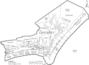
Municipalities and communities of Carteret County, North Carolina, United States | ||
|---|---|---|
| Towns |  | |
| CDPs | ||
| Other unincorporated communities | ||
| Ghost towns | ||