Mouchamps
| Mouchamps | |
|---|---|
|
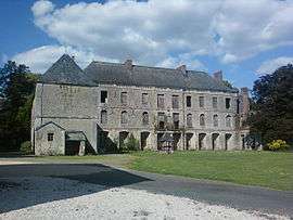
The Château of Soubise Park | |
 Mouchamps | |
|
Location within Pays de la Loire region  Mouchamps | |
| Coordinates: 46°46′53″N 1°03′42″W / 46.7814°N 1.0617°WCoordinates: 46°46′53″N 1°03′42″W / 46.7814°N 1.0617°W | |
| Country | France |
| Region | Pays de la Loire |
| Department | Vendée |
| Arrondissement | La Roche-sur-Yon |
| Canton | Les Herbiers |
| Intercommunality | Pays des Herbiers |
| Government | |
| • Mayor (2014–2020) | Hervé Robineau |
| Area1 | 55 km2 (21 sq mi) |
| Population (2006)2 | 2,628 |
| • Density | 48/km2 (120/sq mi) |
| Time zone | CET (UTC+1) |
| • Summer (DST) | CEST (UTC+2) |
| INSEE/Postal code | 85153 / 85640 |
| Elevation | 47–121 m (154–397 ft) |
|
1 French Land Register data, which excludes lakes, ponds, glaciers > 1 km² (0.386 sq mi or 247 acres) and river estuaries. 2 Population without double counting: residents of multiple communes (e.g., students and military personnel) only counted once. | |
Mouchamps is a commune in the Vendée department in the Pays de la Loire region in western France.
The gravesite of the noted French politician, Georges Clemenceau, is located near Mouchamps at the small hamlet of Le Colombier. To get to the gravesite of Clemenceau, follow the D28 road from the center of Mouchamps northeastward approximately two and one-half miles to a road on the right signposted as "La Brachetiere", "La Monceliere", and "Colombier". Very shortly after making that initial right turn, make another right turn at the sign marked "Tombeau de Clemenceau". A separate sign says "Colombier". Continue on that road for approximately one and one-half miles, and the tomb (along with that of his father) is on the left (down a short walk in a small wooded area.)
See also
References
| Wikimedia Commons has media related to Mouchamps. |