Saint-Valérien, Vendée
| Saint-Valérien | |
|---|---|
|
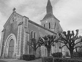
The church of Saint-Pierre and Saint-Valérien | |
 Saint-Valérien | |
|
Location within Pays de la Loire region  Saint-Valérien | |
| Coordinates: 46°31′45″N 0°56′17″W / 46.5292°N 0.9381°WCoordinates: 46°31′45″N 0°56′17″W / 46.5292°N 0.9381°W | |
| Country | France |
| Region | Pays de la Loire |
| Department | Vendée |
| Arrondissement | Fontenay-le-Comte |
| Canton | L’Hermenault |
| Intercommunality | Pays de l'Hermenault |
| Government | |
| • Mayor (2008–2014) | Pierre Defrance |
| Area1 | 14.30 km2 (5.52 sq mi) |
| Population (2006)2 | 477 |
| • Density | 33/km2 (86/sq mi) |
| Time zone | CET (UTC+1) |
| • Summer (DST) | CEST (UTC+2) |
| INSEE/Postal code | 85274 / 85570 |
| Elevation | 32–74 m (105–243 ft) |
|
1 French Land Register data, which excludes lakes, ponds, glaciers > 1 km² (0.386 sq mi or 247 acres) and river estuaries. 2 Population without double counting: residents of multiple communes (e.g., students and military personnel) only counted once. | |
Saint-Valérien is a commune in the Vendée department in the Pays de la Loire region in western France.
Geography
The river Smagne forms all of the commune's northern border.
See also
References
| Wikimedia Commons has media related to Saint-Valérien (Vendée). |
This article is issued from Wikipedia - version of the 2/22/2015. The text is available under the Creative Commons Attribution/Share Alike but additional terms may apply for the media files.