Mount Charleston, Nevada
| Mount Charleston, Nevada | |
|---|---|
| Unincorporated town | |
 | |
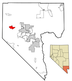 Location of Mount Charleston in Clark County, Nevada | |
 Mount Charleston, Nevada Location in the United States | |
| Coordinates: 36°15′29″N 115°38′6″W / 36.25806°N 115.63500°WCoordinates: 36°15′29″N 115°38′6″W / 36.25806°N 115.63500°W | |
| Country | United States |
| State | Nevada |
| County | Clark |
| Area | |
| • Total | 29.4 sq mi (76.0 km2) |
| • Land | 29.4 sq mi (76.0 km2) |
| • Water | 0.0 sq mi (0.0 km2) |
| Elevation | 7,510 ft (2,289 m) |
| Population (2010) | |
| • Total | 357 |
| • Density | 9.7/sq mi (3.8/km2) |
| Time zone | PST (UTC-8) |
| • Summer (DST) | PDT (UTC-7) |
| ZIP code | 89124 |
| Area code(s) | 702 |
| FIPS code | 32-49310 |
| GNIS feature ID | 0859202 |
| Website | Mount Charleston Town Advisory Board |
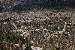
Mount Charleston is an unincorporated town[1] and census-designated place in Clark County, Nevada, United States. The population was 357 at the 2010 census.[2]
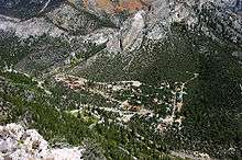
Named for nearby Mount Charleston, the highest point in Clark County, the town is in a valley of the Spring Mountains to the northwest of Las Vegas, noted for its hiking trails, and for the Mount Charleston Lodge, a rustic hotel. At an elevation of approximately 7,500 feet, temperatures are much lower than in Las Vegas, which has an elevation of about 2,000 feet, making it a popular place for Las Vegans to vacation. The mean high temperature is 20.4 degrees (Fahrenheit) cooler than in Las Vegas. The area is also known as a vacation village for wealthy Las Vegas residents.[3]
Geography
According to the United States Census Bureau, the census-designated place (CDP) of Mount Charleston (which may not coincide exactly with the town boundaries) has a total area of 29.4 square miles (76 km2), all of it land.
Demographics
As of the census[4] of 2000, there were 285 people, 133 households, and 80 families residing in the CDP. The population density was 9.7 people per square mile (3.7/km²). There were 362 housing units at an average density of 12.3 per square mile (4.8/km²). The racial makeup of the CDP was 97.54% White, 1.05% African American, 0.35% Pacific Islander, 0.70% from other races, and 0.35% from two or more races. Hispanic or Latino of any race were 2.46% of the population.
There were 133 households out of which 18.0% had children under the age of 18 living with them, 52.6% were married couples living together, 4.5% had a female householder with no husband present, and 39.8% were non-families. 29.3% of all households were made up of individuals and 2.3% had someone living alone who was 65 years of age or older. The average household size was 2.14 and the average family size was 2.69.
In the CDP the population was spread out with 15.8% under the age of 18, 3.9% from 18 to 24, 21.8% from 25 to 44, 45.3% from 45 to 64, and 13.3% who were 65 years of age or older. The median age was 49 years. For every 100 females there were 119.2 males. For every 100 females age 18 and over, there were 124.3 males.
The median income for a household in the CDP was $63,125, and the median income for a family was $67,625. Males had a median income of $75,471 versus $35,938 for females. The per capita income for the CDP was $38,821. None of the population or families were below the poverty line.

Transportation
Access to the community is from State Route 156 and State Route 157.
Climate
Mount Charleston has a borderline Mediterranean/continental Mediterranean climate (Köppen Csb/Dsb), very similar to that of Flagstaff, Arizona though with rather less frequent and abundant monsoonal storms. In contrast to the arid climate of the rest of Nevada, precipitation as rain and melted snow is sufficient to support coniferous forests, with typically 11 inches or 0.28 metres of snow on the ground in February and a maximum monthly snowfall in a limited record of 89 inches or 2.26 metres in December 2010. Summers are markedly cooler than in the lower deserts, with the average July high being only 79.4 °F or 26.3 °C and minima often below 50 °F or 10 °C. On average over half of all nights are below 32 °F or 0 °C and in extreme cold waves temperatures may fall below 0 °F or −17.8 °C, with −15 °F (−26.1 °C) reached during the 1949 Western North American cold wave.
| Climate data for Mount Charleston Lodge, Nevada. (Elevation 7,420ft) | |||||||||||||
|---|---|---|---|---|---|---|---|---|---|---|---|---|---|
| Month | Jan | Feb | Mar | Apr | May | Jun | Jul | Aug | Sep | Oct | Nov | Dec | Year |
| Record high °F (°C) | 70 (21) |
69 (21) |
73 (23) |
79 (26) |
86 (30) |
93 (34) |
98 (37) |
93 (34) |
90 (32) |
83 (28) |
79 (26) |
69 (21) |
98 (37) |
| Average high °F (°C) | 44.0 (6.7) |
43.4 (6.3) |
48.8 (9.3) |
54.8 (12.7) |
64.4 (18) |
74.1 (23.4) |
79.4 (26.3) |
78.2 (25.7) |
71.7 (22.1) |
61.4 (16.3) |
51.6 (10.9) |
44.3 (6.8) |
59.7 (15.4) |
| Average low °F (°C) | 19.2 (−7.1) |
19.8 (−6.8) |
23.5 (−4.7) |
28.2 (−2.1) |
36.4 (2.4) |
44.1 (6.7) |
52.0 (11.1) |
50.6 (10.3) |
43.5 (6.4) |
34.5 (1.4) |
26.0 (−3.3) |
19.4 (−7) |
33.1 (0.6) |
| Record low °F (°C) | −11 (−24) |
−15 (−26) |
1 (−17) |
7 (−14) |
16 (−9) |
17 (−8) |
31 (−1) |
30 (−1) |
17 (−8) |
9 (−13) |
1 (−17) |
−18 (−28) |
−18 (−28) |
| Average precipitation inches (mm) | 2.83 (71.9) |
3.51 (89.2) |
1.92 (48.8) |
1.23 (31.2) |
0.70 (17.8) |
0.29 (7.4) |
2.13 (54.1) |
1.89 (48) |
1.69 (42.9) |
1.96 (49.8) |
1.31 (33.3) |
3.61 (91.7) |
23.07 (586.1) |
| Average snowfall inches (cm) | 18.2 (46.2) |
29.3 (74.4) |
13.2 (33.5) |
8.3 (21.1) |
1.0 (2.5) |
0.2 (0.5) |
0 (0) |
0 (0) |
0 (0) |
1.6 (4.1) |
5.2 (13.2) |
20.0 (50.8) |
97.1 (246.6) |
| Average precipitation days (≥ 0.01 inch) | 4 | 6 | 5 | 4 | 2 | 2 | 6 | 4 | 3 | 3 | 3 | 5 | 47 |
| Source: The Western Regional Climate Center[5] | |||||||||||||
References
- ↑ http://www.clarkcountynv.gov/Depts/admin_services/tlservices/Pages/Mt%20Charleston%20Town%20Advisory%20Board.aspx Mount Charleston Town Board
- ↑ "Profile of General Population and Housing Characteristics: 2010 Demographic Profile Data (DP-1): Mount Charleston CDP, Nevada". U.S. Census Bureau, American Factfinder. Retrieved March 13, 2012.
- ↑
- ↑ "American FactFinder". United States Census Bureau. Retrieved 2008-01-31.
- ↑ "MT. CHARLESTON F.S., NEVADA: Period of Record General Climate Summary". Western Regional Climate Center. Retrieved July 27, 2015.
External links
| Wikimedia Commons has media related to Mount Charleston, Nevada. |
Municipalities and communities of Clark County, Nevada, United States | ||
|---|---|---|
| Cities |  | |
| CDPs | ||
| Unincorporated communities | ||
| Townships |
| |
| Ghost towns | ||
| Indian reservations | ||
| Footnotes | ‡This populated place also has portions in an adjacent county or counties | |