Simonsville, Nevada
| Simonsville | |
|---|---|
| Ghost town | |
 Simonsville  Simonsville Location within the state of Nevada | |
| Coordinates: 36°33′46″N 114°26′40″W / 36.56278°N 114.44444°WCoordinates: 36°33′46″N 114°26′40″W / 36.56278°N 114.44444°W | |
| Country | United States |
| State | Nevada |
| County | Clark |
| Elevation | 1,325 ft (404 m) |
| Time zone | Pacific (PST) (UTC-8) |
| • Summer (DST) | PDT (UTC-7) |
| GNIS feature ID | 851286[1] |
Simonsville is a ghost town in Clark County, Nevada, that was located on the east bank of the Muddy River west of the south end of the Overton Airport in the Moapa Valley.[1]
History
Simonsville was originally called Mill Point for the grist mill first built there by James Leithead. The name was changed changed to Simonsville in December 1865, named after Orrawell Simons who would build another mill there in 1866.[1][2] Simonsville was abandoned in 1870 like most of the Mormon farms and settlements in the Moapa Valley, due to a tax dispute with the Nevada state government, and it was never reoccupied.
Today
The site of Simonsville is occupied by more recent structures.
References
- 1 2 3 U.S. Geological Survey Geographic Names Information System: Simonsville (historical)
- ↑ Avertt, Walter R. Directory of Southern Nevada Place Names. Revised edition: printed by the author, 1963, p.70
Municipalities and communities of Clark County, Nevada, United States | ||
|---|---|---|
| Cities | 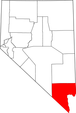 | |
| CDPs | ||
| Unincorporated communities | ||
| Townships |
| |
| Ghost towns | ||
| Indian reservations | ||
| Footnotes | ‡This populated place also has portions in an adjacent county or counties | |
This article is issued from Wikipedia - version of the 8/3/2016. The text is available under the Creative Commons Attribution/Share Alike but additional terms may apply for the media files.