Paradise, Nevada
Coordinates: 36°4′55″N 115°7′29″W / 36.08194°N 115.12472°W
| Paradise, Nevada | |
|---|---|
| Unincorporated town | |
|
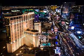
The Las Vegas Strip, largely located within Paradise | |
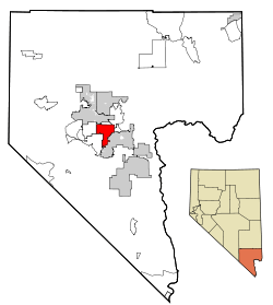 Location of Paradise in Clark County, Nevada | |
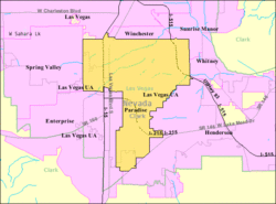 U.S. Census Map | |
 Paradise, Nevada Location in the United States | |
| Coordinates: 36°4′55″N 115°7′29″W / 36.08194°N 115.12472°W | |
| Country | United States |
| State | Nevada |
| County | Clark |
| Area | |
| • Total | 46.7 sq mi (121 km2) |
| • Land | 46.7 sq mi (121 km2) |
| • Water | 0.0 sq mi (0 km2) |
| Elevation | 2,057 ft (627 m) |
| Population (2010) | |
| • Total | 223,167 |
| • Density | 4,777/sq mi (1,844/km2) |
| Time zone | PST (UTC-8) |
| • Summer (DST) | PDT (UTC-7) |
| Area code(s) | 702 |
| FIPS code | 32-54600 |
| GNIS feature ID | 0845094 |
| Website | Paradise Town Advisory Board |
Paradise is an unincorporated town[1] and census-designated place (CDP) in Clark County, Nevada, United States, adjacent to the city of Las Vegas. The population was 223,167 at the 2010 census,[2] making it the most populous unincorporated community in Nevada and more populous than any city in the state outside Clark County. As an unincorporated town, it is governed by the Clark County Commission with input from the Paradise Town Advisory Board. Paradise was formed on December 8, 1950.[3]
Paradise contains McCarran International Airport; the University of Nevada, Las Vegas; and most of the Las Vegas Strip. Paradise contains most tourist attractions in the Las Vegas area, excluding downtown. Despite this, the name Paradise remains relatively unknown. All Paradise ZIP codes have Las Vegas mailing addresses.
Las Vegas has gotten their first professional league sports team, the Vegas Golden Knights, who will play in the National Hockey League at T-Mobile Arena. The Knights will begin playing in the 2017-18 NHL season.
History
The southern part of the Las Vegas Valley was referred to as Paradise Valley as early as 1910, owing to a high water table that made the land particularly fertile for farming.[4][5] County commissioners established a Paradise school district in 1914.[6]

In 1950, mayor Ernie Cragin of Las Vegas, looking to fund an ambitious building agenda and pay down the city's rising debt, sought to expand the city's tax base by annexing the Las Vegas Strip which was unincorporated territory.[7] A group of casino executives, led by Gus Greenbaum of the Flamingo, lobbied the county commissioners for township status which would prevent the city from annexing the land without the commission's approval.[7] The commission voted to create the unincorporated township of Paradise on December 8, 1950.
In April 1951, the town of Paradise "A" was founded, followed by a Paradise "B" in January 1952. Paradise "A" was renamed Winchester, Nevada and Paradise "B" was renamed Paradise, Nevada in 1953.
In 1975, Nevada enacted a law that would have incorporated Paradise (along with Sunrise Manor and Winchester) into the City of Las Vegas.[8] Before it could take effect, however, the bill was struck down as unconstitutional by the Nevada Supreme Court.[9][10]
Geography
According to the United States Census Bureau, the census-designated place (CDP) of Paradise (which may not coincide exactly with the town boundaries) has a total area of 46.7 square miles (121 km2), all of it land.
Demographics
| Historical population | |||
|---|---|---|---|
| Census | Pop. | %± | |
| 1970 | 24,477 | — | |
| 1980 | 84,818 | 246.5% | |
| 1990 | 124,682 | 47.0% | |
| 2000 | 186,070 | 49.2% | |
| 2010 | 223,167 | 19.9% | |
| source:[11] | |||
At the census of 2010,[12] there were 223,167 people residing in Paradise. The racial makeup was 59.8% White, 8.9% African American, 0.8% Native American, 9.5% Asian, 1.0% Pacific Islander, and 5.5% from two or more races. Hispanic or Latino of any race were 31.2% of the population and 46.3% of the population was non-Hispanic White.
As of the census[13] of 2000, there were 186,070 people, 77,209 households, and 43,314 families residing in the CDP. The population density was 3,947.3 people per square mile (1,524.0/km²). There were 85,398 housing units at an average density of 1,811.6 per square mile (699.5/km²). The racial makeup of the CDP was 72.51% White, 6.59% African American, 0.77% Native American, 6.52% Asian, 0.59% Pacific Islander, 8.37% from other races, and 4.65% from two or more races. Hispanic or Latino of any race were 23.47% of the population.
There were 77,209 households out of which 24.6% had children under the age of 18 living with them, 39.7% were married couples living together, 10.5% had a female householder with no husband present, and 43.9% were non-families. 31.9% of all households were made up of individuals and 7.5% had someone living alone who was 65 years of age or older. The average household size was 2.39 and the average family size was 3.04.
In the CDP the population was spread out with 21.2% under the age of 18, 10.8% from 18 to 24, 33.3% from 25 to 44, 23.6% from 45 to 64, and 11.1% who were 65 years of age or older. The median age was 35 years. For every 100 females there were 109.1 males. For every 100 females age 18 and over, there were 110.0 males.
The median income for a household in the CDP was $39,376, and the median income for a family was $46,578. Males had a median income of $31,412 versus $25,898 for females. The per capita income for the CDP was $21,258. 11.8% of the population and 8.1% of families were below the poverty line. 15.3% of those under the age of 18 and 7.6% of those 65 and older are living below the poverty line.
At about 225,000 people, if Paradise were to be an incorporated city it would be either the fourth or fifth largest city in the state, after Las Vegas (585,000), Henderson (260,000), and North Las Vegas (229,000); Reno has a population of about 225,000.
Culture
_(5395252538).jpg)
- Akhob by James Turrell
- The Art of Richard MacDonald
- Bellagio Gallery of Fine Art
- Bliss Dance
- Chihuly Art Gallery
- Las Vegas Little Theater
- Las Vegas Philharmonic Orchestra
- Martin Lawrence Galleries
- Nevada Ballet Theatre
- P3 Art Studio
- Peter Lik Fine Art Photography
- Rodney Lough Jr. Wilderness Gallery
- National Atomic Testing Museum
- Liberace Museum
- Marjorie Barrick Museum
Education
The Clark County School District serves Paradise as well as all of Clark County. The township is home to the University of Nevada, Las Vegas.
See also
References
- ↑ Paradise Town Board
- ↑ "Profile of General Population and Housing Characteristics: 2010 Demographic Profile Data (DP-1): Paradise CDP, Nevada". U.S. Census Bureau, American Factfinder. Retrieved March 13, 2012.
- ↑ Kanigher, Steve (July 18, 2003). "Las Vegas: Bright lights, but not a big city". Las Vegas Sun. Retrieved October 8, 2012.
- ↑ F. Andrew Taylor (August 3, 2010). "Origin of many Clark County township names is a mystery". Anthem View. Las Vegas – via NewsBank.
- ↑ "Paradise Valley well named". Las Vegas Age. May 28, 1910.
- ↑ "County board met Monday". Las Vegas Age. November 7, 1914.
- 1 2 Moehring, Eugene P. (2000). Resort City in the Sunbelt: Las Vegas, 1930-2000. University of Nevada Press. p. 87. ISBN 0-87417-356-6.
- ↑ "Clark consolidation bill signed". Nevada State Journal. Reno, NV. AP. May 22, 1975. – via Newspapers.com (subscription required)
- ↑ Michael Mishak (May 24, 2009). "Why consolidating city and county governments isn't a silver bullet for waste". Las Vegas Sun. Retrieved 2015-07-12.
- ↑ County of Clark v. City of Las Vegas, 550 P.2d 779 (Nev. 1976).
- ↑ "Census of Population and Housing (1790-2000)". United States Census Bureau. Retrieved 2010-07-17.
- ↑ http://quickfacts.census.gov/qfd/states/32/3254600.html
- ↑ "American FactFinder". United States Census Bureau. Retrieved 2008-01-31.
External links
| Wikimedia Commons has media related to Paradise, Nevada. |
Municipalities and communities of Clark County, Nevada, United States | ||
|---|---|---|
| Cities | 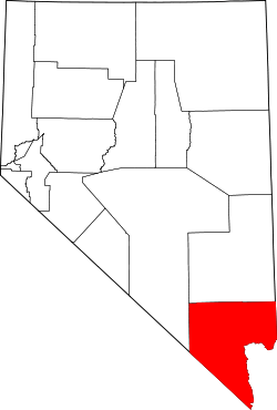 | |
| CDPs | ||
| Unincorporated communities | ||
| Townships |
| |
| Ghost towns | ||
| Indian reservations | ||
| Footnotes | ‡This populated place also has portions in an adjacent county or counties | |