Kadifekale
| Kadifekale | |
|---|---|
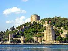
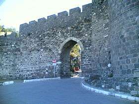 Entry of the castle walls in Kadifekale | |
| Highest point | |
| Elevation | 186 m (610 ft) |
| Geography | |
| Location | Konak metropolitan district, İzmir, Turkey |
Kadifekale (literally "the velvet castle" in Turkish) is the name of the hill located within the urban zone of İzmir, Turkey, as well as being the name of the ancient castle on top of the same hill.
Both the hill and the castle were named Pagos (Greek: Πάγος, Pagus under the Roman Empire) in pre-Turkish times and by the local Greeks in modern times.
The summit where the castle is found is located at a distance of about 2 km from the shoreline and commands a general view of a large part of the city of İzmir, as well as of the Gulf of İzmir.
Administratively, the hill area covers six quarters constituted by slums in their large part, one named Kadifekale like the hill, and others Alireis, Altay, İmariye, Kosova and Yenimahalle.[1]
In 2007, the metropolitan municipality of İzmir started renovation and restoration works in Kadifekale.
Re-foundation of Smyrna on Mount Pagos
The first recorded defensive walls built here was the work of Lysimachos, a "successor" (diadochus) of Alexander the Great, later a king (306 BC) in Thrace and Asia Minor. This construction was associated with Alexander's re-foundation of Smyrna, moving it from Old Smyrna on a mound in the southeastern corner of the inner gulf where only a few thousand people could be accommodated. This move for the location of a new and larger city gained fame in a legend told by Pausanias, according to which Alexander, during a rest after hunting under a plane tree near the sanctuary on the hill of the two Nemeseis worshipped by the Smyrneans, was approached during his sleep by the goddesses who bade him found a city on that very spot, transferring to it the inhabitants of the earlier site. Upon this, the famous oracle in Klaros was consulted and the answer received was;
Three and four times happy shall those men be hereafter, who shall dwell on Pagus beyond the sacred Meles.
While Alexander could only act as inspirator and/or initiator for the move, the recent excavations in Old Smyrna have shown that the settlement there could have ceased even during his lifetime. The legend, in the meantime, was frequently depicted on ancient coins.
Tale of Two Cities
Strabo records that only a small part of Smyrna was located on the mound, with the greater part centered around the harbor on the flatlands below. The stadium and the theatre on the other hand, were on the slopes immediately below the summit. The settlements on the hill and those near the coast had a separate history in certain periods, as it was the case during the 14th century, when the hill castle was captured by the Aydinids, and the port city, with another castle, was held by the Genoese until its capture by Tamerlane in 1403. During the 19th century, Kadifekale was part of the chain across several slopes which constituted İzmir's Turkish core, while the urban center below was the cosmopolitan part.
The present walls are medieval. A number of sources put forth claims on having observed fragments of Hellenic masonry under the existing walls, but these fell short of having acquired general acceptance. The long hollow west of the castle marks the site of the Stadium, scene of the martyrdom of St. Polycarp, and it is now completely built over. This is also the case for the ancient theatre of Smyrna, which is located to the east of the castle gates, although there a few traces are still visible to the naked eye. Both works belong to a reconstruction following a calamitous earthquake in 178.
Next to the castle are the ruins of the cisterns built during the Roman period and renovated during the Byzantine and Ottoman periods. They formed the centre of the drinking water network of Smyrna. The remains of this network are still preserved in the agora of Smyrna in downtown İzmir.
Gallery
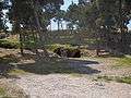 Cisterns
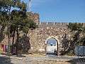 Castle gate
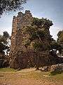 Watch tower
 Castle wall
Footnotes
- ↑ Of these quarters, "Alireis" is notable in being one of the initial 15th-16th century Ottoman urban wards of İzmir's Turkish settlement which had started in Kadifekale in the 14th century. Just below the castle on the slopes facing the sea, the quarter was mentioned under the name "Ali Çavuş" in one of the first extant Ottoman records on İzmir, which is dated 1576. Three quarters neighboring Alireis to the north-east, respectively "Masjid-i Selatinzade" (the quarter now named "Kubilay" with the name of the local mosque remaining the same; "Selatinoğlu"), "Hanbey" or "Pazar" (now named "Pazaryeri") and "Faikpaşa" (still called under the same name) are earlier still and were recorded in the very first extant imperial records mentinoning the four original urban wards and one depending village of Ottoman İzmir, corresponding to a total population estimated between 2500-4000. Of these, Pazaryeri is just above the Agora of Smyrna, while the Roman-era theatre could still be tracked in the beginning of the 20th century from Faikpaşa quarter to the Basmane train station slightly below to the north-west. Guide to the Eastern Mediterranean. Macmillan Publishing. 1904.
Books
- Ekrem Akurgal (2002). Ancient Civilizations and Ruins of Turkey: From Prehistoric Times Until the End of the Roman Empire ISBN 0-7103-0776-4. Kegan Paul.
- George E. Bean. Aegean Turkey: An archaeological guide ISBN 978-0-510-03200-5, 1967. Ernest Benn, London.
- Cecil John Cadoux (1938). Ancient Smyrna: A History of the City from the Earliest Times to 324 A.D. Blackwell Publishing.
External links
| Wikimedia Commons has media related to Kadifekale. |
- Images of Kadifekale
- A. Karayiğit (July 2005). Report: "Kadifekale'nin sosyo-ekonomik profili ve sorunları (Kadifekale's socio-economic profile and problems) 25p." Check
|url=value (help) (PDF) (in Turkish). İzmir Chamber of Commerce. External link in|publisher=(help)
Coordinates: 38°24′51.1″N 27°08′43.7″E / 38.414194°N 27.145472°E
| Settlements |
| ||||||
|---|---|---|---|---|---|---|---|
| History | |||||||
| Universities | |||||||
| Museums and Monuments | |||||||
| Mosques | |||||||
| Transportation | |||||||
| Buildings and structures | |||||||
| Squares | |||||||