Multnomah Falls
| Multnomah Falls | |
|---|---|
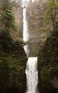
|
Full view of both tiers | |
| Location | Columbia River Gorge, Multnomah County, Oregon, USA |
| Type | Tiered |
| Elevation | 627 ft (191 m) |
| Total height | 620 ft (189 m) |
| Number of drops | 2 |
| Longest drop | 542 ft (165 m) |
| Watercourse | Multnomah Creek |
| Average flow rate | 150 cu ft/s (4.2 m3/s) |
| World height ranking | 434 |
Multnomah Falls is a waterfall on the Oregon side of the Columbia River Gorge, located east of Troutdale, between Corbett and Dodson, along the Historic Columbia River Highway.
Formation
The waterfall formed as result of the Missoula Floods.[1][2]
How the falls drops
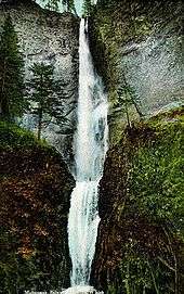
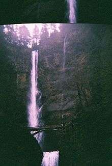
The falls drops in two major steps, split into an upper falls of 542 feet (165 m) and a lower falls of 69 feet (21 m), with a gradual 9 foot (3 m) drop in elevation between the two, so the total height of the waterfall is conventionally given as 620 feet (189 m). The two drops are due to a zone of more easily eroded basalt at the base of the upper falls.[3]
Height
Multnomah Falls is the tallest waterfall in the state of Oregon. It is credited by a sign at the site of the falls, and by the United States Forest Service, as the second tallest year-round waterfall in the United States.[4] However, there is some skepticism surrounding this distinction, as Multnomah Falls is listed as the 137th tallest waterfall in the United States by the World Waterfall Database (this site does not distinguish between seasonal and year-round waterfalls).[5][6]

Water Source
Underground springs from Larch Mountain are the year-round source of water for the waterfall, augmented by spring runoff from the mountain's snowpack and rainwater during the other seasons.
Trails
A foot trail leads to Benson Footbridge, a 45-foot (14 m)-long footbridge that allows visitors to cross 105 feet (32 m) above the lower cascade. The trail continues to a platform at the top of the upper falls where visitors get a bird's-eye view of the Columbia Gorge and also of "Little Multnomah", a small cascade slightly upstream from the "upper" falls, which is not visible from ground level. The Mark O. Hatfield Memorial Trail starts at the falls and continues through the Oregon side of the Columbia River Gorge to Starvation Creek. The footbridge is named for Simon Benson, who in 1914 financed Italian stonemasons to construct the bridge.
The land, and the building
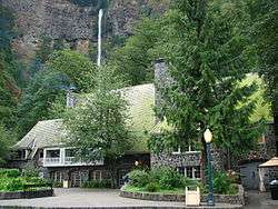
Benson soon gave Portland land that included most of the falls as well as nearby Wahkeena Falls. The Oregon-Washington Railroad and Navigation Company gave Portland land at the base of Multnomah Falls contingent upon their agreement to build a lodge at the site. A few years later architect A.E. Doyle, who designed the Meier & Frank Building, was commissioned by the city to design the lodge, which was completed in 1925.[7] The lodge is now on the National Register of Historic Places.[7]
Access
In contrast to other falls along the Gorge, the Multnomah area is also reachable via a stretch of I-84 east of Troutdale, Oregon. The rest area and tunnel under the road (as well as the Union Pacific Railroad tracks) allow Interstate travelers from either direction to stop and visit the falls.
Falling boulders
On Labor Day in September 1995, a 400-ton boulder, loosened by erosion, fell 225 feet (69 m) from the face of the waterfall into the upper cascade pool, above Benson Bridge. It caused a 70-foot (21 m) splash of water and gravel to wash over the footbridge, causing minor injuries to twenty members of a wedding party that happened to be on the bridge posing for photos at the time.[8]
On January 9, 2014, a falling rock damaged a portion of the bridge walkway and concrete railing, leading the Forest Service to close the bridge until repairs were completed.[9]
|
Multnomah Falls Lodge and Footpath | |
 | |
| Location | Bridal Veil, Oregon, vicinity[10] |
|---|---|
| Nearest city | Cascade Locks, Oregon |
| Coordinates | 45°34′33″N 122°06′55″W / 45.57595°N 122.11536°W |
| Built | 1915[10] |
| Architect | A.E. Doyle[7] |
| NRHP Reference # | 81000512[10] |
| Added to NRHP | April 22, 1981[10] |
References
- ↑ "Missoula Flood & Multnomah Falls, Oregon - Glacial Lake Missoula Flood Features". Waymarking.com. 2007-02-05. Retrieved 2016-10-18.
- ↑ "Missoula Floods". The Columbia River. Retrieved 2016-10-18.
- ↑ "Multnomah Falls plummets 620 feet". Multnomah Falls Lodge. Retrieved 2016-10-18.
- ↑ "U.S. Forest Service: Columbia River Gorge National Scenic Area". Retrieved August 28, 2012.
- ↑ "Tallest Waterfalls in the U.S.". Retrieved August 28, 2012.
- ↑ "Multnomah Falls". Retrieved August 28, 2012.
- 1 2 3 "National Register of Historic Places Registration Form: Multnomah Falls Lodge and Footpath" (PDF). National Park Service. March 11, 1981. Retrieved July 11, 2011.
- ↑ Columbia Gorge Waterfalls, Historic The Dalles
- ↑ Blackman, Teresa. "Large rock falls on iconic bridge at Multnomah Falls". KGW Newschannel 8, Portland. Archived from the original on May 30, 2014. Retrieved 10 January 2014.
- 1 2 3 4 Oregon Parks and Recreation Department (2007-07-16). "Oregon National Register List" (PDF). Retrieved 2008-03-29
External links
| Wikimedia Commons has media related to Multnomah Falls. |
- Multnomah Falls and Welcome to Multnomah Falls, from a USFS website
- Multnomah Falls from the Oregon Tourism Commission
- Built in America: Columbia River Highway, from a Library of Congress website
- Historic Columbia River Highway
- Old Postcards of Multnomah Falls
- Hiking Multnomah Falls
- Excerpt from Historic American Engineering Record report on Benson Footbridge
- Native American Legend: Coyote and Multnomah Falls