Murray Bridge, South Australia
| Murray Bridge South Australia | |||||||||||||
|---|---|---|---|---|---|---|---|---|---|---|---|---|---|
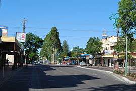 Main street of Murray Bridge | |||||||||||||
 Murray Bridge | |||||||||||||
| Coordinates | 35°07′01″S 139°16′01″E / 35.117°S 139.267°ECoordinates: 35°07′01″S 139°16′01″E / 35.117°S 139.267°E | ||||||||||||
| Population | 17,921 (2015)[1] | ||||||||||||
| • Density | 183.81/km2 (476.05/sq mi) | ||||||||||||
| Established | 1924 | ||||||||||||
| Postcode(s) | 5253[2] | ||||||||||||
| Area | 97.5 km2 (37.6 sq mi)[3] (2011 urban) | ||||||||||||
| Time zone | ACST (UTC+9:30) | ||||||||||||
| • Summer (DST) | ACDT (UTC+10:30) | ||||||||||||
| Location | 76 km (47 mi) ESE of Adelaide | ||||||||||||
| LGA(s) | Rural City of Murray Bridge | ||||||||||||
| State electorate(s) | Hammond | ||||||||||||
| Federal Division(s) | Barker | ||||||||||||
| |||||||||||||
Murray Bridge (formerly Mobilong and Edwards Crossing) is a city in the Australian state of South Australia, located 76 kilometres (47 mi) east-southeast of the state's capital city, Adelaide, and 77 kilometres (48 mi) north of the town of Meningie. The city has an estimated urban population of 17,921 at June 2015.[1] making the city the fifth most populous urban area in the state,[1] after Adelaide, Mount Gambier, Victor Harbour - Goolwa and Whyalla.
The city was originally known as Mobilong and later as Edwards Crossing, before being renamed as Murray Bridge in 1924;[4][5] deriving its name from the road and railway crossings over the Murray River. The city is situated on the Princes Highway, the main road transport link between Adelaide and Melbourne.
The city services a farming area including dairy, pigs, chickens, cereal crops and vegetables (including "stay crisp lettuces").
History
Murray Bridge is in the traditional lands of the Ngarrindjeri people, who refer to Murray Bridge as Pomberuk. The first European explorer was Charles Sturt who camped there on 8 February 1830.
The first road bridge across the lower Murray was completed at Murray Bridge in 1879. The bridge also became a shared road and rail bridge in 1886 until the separate rail bridge was completed in 1925.[6] The bridge was designed for 1,067 mm (3 ft 6 in)[7] rail track gauge though in actuality, only 1,600 mm (5 ft 3 in) gauge trains ever used it.
In 1979 the Swanport Bridge, carrying the South Eastern Freeway across the Murray River was completed 5 kilometres (3 mi) downstream, removing most through traffic from the historic Murray Bridge.
Murray Bridge contains a number of heritage-listed sites, including the Murray Bridge Transport Precinct, listed on the South Australian Heritage Register.[8]
Demographics
The urban area that contains and surrounds Murray Bridge had a population of 16,708 as at the 2011 census.[9] In the 2006 census, the population was 14,048[10] and at the 2001 census, the population was 12,998.
In the 2006 Census, 10.4% of the population were born overseas, and 4.5% were Indigenous Australians. The median weekly household income was A$639 per week, compared with $924 in Adelaide. 13.3% of the population identified themselves as Lutheran, while a higher 24.7% identified with no religion.[10]
Sport and recreation
In 1924 the Murray Bridge rowing team was chosen to represent Australia at the Paris Olympics. The Murray Cods as they were known won the Australian Eight Oared Championships (the King's Cup) and were invited to compete in a test race at Port Adelaide between South Australia, Western Australia, Tasmania and Victoria. Although accustomed to rowing over 3 miles, the Murray Cods were able to defeat the other crews on the 1 mile and 420 yards (2 km) course. The story of their fund-raising and exploits in Paris are detailed on the Australian Rowing History website.[11]
Murray Bridge is home to the infamous Bunyip, a mechanical replica of the legendary monster is located on Sturt Reserve. Many South Australian children fondly remember their first visit to the Bunyip, putting a coin in the machine and watching the Bunyip emerge from its watery cage complete with shrieking sound effects.
Murray Bridge is also home to the River Murray Football League, which plays Australian rules football. The league consists of the Murray Bridge-based clubs of Ramblers and Imperials and the district teams of Mypolonga, Mannum, Tailem Bend, Jervois and Meningie.
In 2005 the city's golf course, Murray Bridge Golf Club, held the State's premier regional junior team event, the Brett Ogle Cup (named after the Australian Professional golfer Brett Ogle). The home team went undefeated and qualified for the state final, losing narrowly. The team had not previously experienced such success; junior golf in the region has since obtained a higher profile.
Another sporting association in Murray Bridge is the Murray Bridge Amateur Swim Club (The Cods) which competes in meets with other clubs, as well as Country Championships (a large meet for all of the rural South Australian swim clubs) and state and national championships.
Murray Bridge is also the home of the Murray Bridge Racing Club, Murray Bridge & District Table Tennis Association, and holds the 24-hour Australian International Pedal Prix race annually in September. Murray Bridge Lutheran Tennis Club plays hard court tennis on their home courts based at Christian Reserve. Hard court tennis is hosted by various clubs throughout the community, including Jervois, Brinkley, Mannum, Mypolonga and Tailem Bend as well as clubs within the township. Hard court tennis is played on both Friday nights and Saturday mornings. There are both Junior and senior divisions. Friday night tennis offers a social alternative, often offering barbecues and after-game drinks. Lawn tennis is played at Sturt Reserve on Saturday mornings and afternoons from October to February, and is organised by the Murray Bridge Lawn Tennis Association.
Murray Bridge also has a rich motor racing history. Established in 1958, Riverview Speedway is one of Australia's premier country dirt track ovals regularly hosting Australian title meetings in most racing categories including bikes and cars.
Murray Bridge is also known for its basketball, having won numerous State Country Championships and many of its young players going on to represent South Australia in the National Championships.
Murray Bridge is also home to the Riverview Speedway which has been in operation since 1958. Located on the eastern side of the River, the speedway is a 360 metres (390 yd) long Dirt track racing venue that caters to both Motorcycle speedway and car racing, hosting numerous Australian and South Australian championships during its existence. On 12 November 2011 the speedway hosted its first ever World Championship event when it will host the FIM 2011 World Sidecar Speedway Championship with Murray Bridge's own Jesse Headland winning the title as passenger to NSW based rider Darrin Treloar. Headland was the winner of the 2010 Championship in England with his father Mick Headland.[12]
Climate
Murray Bridge has a semi-arid climate with warm to hot summers and mild winters, bordering on a Mediterranean climate. The highest recorded temperature of 46.6 °C (115.9 °F) was reached on 28 January 2009 during the early 2009 southeastern Australia heat wave–making it one of the hottest temperatures ever recorded in a South Australian metropolitan area.
| Climate data for Murray Bridge | |||||||||||||
|---|---|---|---|---|---|---|---|---|---|---|---|---|---|
| Month | Jan | Feb | Mar | Apr | May | Jun | Jul | Aug | Sep | Oct | Nov | Dec | Year |
| Record high °C (°F) | 46.6 (115.9) |
46.4 (115.5) |
43.7 (110.7) |
39.2 (102.6) |
31.0 (87.8) |
25.6 (78.1) |
26.7 (80.1) |
30.9 (87.6) |
35.0 (95) |
39.7 (103.5) |
44.2 (111.6) |
44.4 (111.9) |
46.6 (115.9) |
| Average high °C (°F) | 29.1 (84.4) |
29.3 (84.7) |
26.7 (80.1) |
23.5 (74.3) |
19.6 (67.3) |
16.7 (62.1) |
16.2 (61.2) |
17.5 (63.5) |
19.8 (67.6) |
22.7 (72.9) |
25.6 (78.1) |
27.5 (81.5) |
22.8 (73) |
| Average low °C (°F) | 14.6 (58.3) |
14.6 (58.3) |
12.9 (55.2) |
10.3 (50.5) |
8.0 (46.4) |
6.0 (42.8) |
5.4 (41.7) |
5.9 (42.6) |
7.2 (45) |
9.0 (48.2) |
11.4 (52.5) |
13.2 (55.8) |
9.9 (49.8) |
| Record low °C (°F) | 5.1 (41.2) |
5.7 (42.3) |
4.1 (39.4) |
−0.6 (30.9) |
−1.8 (28.8) |
−4.3 (24.3) |
−5.0 (23) |
−2.0 (28.4) |
−1.4 (29.5) |
−0.6 (30.9) |
2.1 (35.8) |
4.0 (39.2) |
−5.0 (23) |
| Average precipitation mm (inches) | 16.4 (0.646) |
18.2 (0.717) |
20.4 (0.803) |
28.8 (1.134) |
34.9 (1.374) |
37.8 (1.488) |
35.2 (1.386) |
37.1 (1.461) |
36.8 (1.449) |
34.0 (1.339) |
25.5 (1.004) |
23.6 (0.929) |
348.5 (13.72) |
| Average precipitation days | 3.8 | 3.9 | 4.8 | 7.7 | 10.4 | 11.8 | 12.4 | 12.8 | 10.5 | 8.9 | 6.1 | 5.3 | 98.4 |
| Source: [13] | |||||||||||||
Retail
Most of Murray Bridge's retail and dining facilities are located on and within close proximity to Bridge Street. An additional shopping complex on Mary Street, completed in November 2011, contains a second Woolworths supermarket, a Big W store, Dick Smith, Priceline, Best & Less, 45 specialty stores, a food court and the public library with undercover parking for over 900 cars. A new addition to the original shopping complex was completed in 2015. A second Coles, and a new Target replacing Target Country, later turned into a Cheap as Chips.
Governance
|
| ||||||||||||||||||||||||||||||||||||
Murray Bridge is part of the state Electoral district of Hammond, which has been held since 2006 by Liberal MP Adrian Pederick. In federal politics, the city is part of the division of Barker, and has been represented by Liberal MP Tony Pasin since 2013. At local level, Murray Bridge is part of the Rural City of Murray Bridge local government area.
The following bounded localities gazetted in South Australia are considered suburbs of the city of Murray Bridge and are governed by the same city council: Avoca Dell, Gifford Hill, Greenbanks, Long Flat, Mobilong, Monteith, Murray Bridge East, Murray Bridge North, Murray Bridge South, Northern Heights, Riverglades, Riverglen, Sunnyside, Swanport, Toora, White Hill, White Sands, and Willow Banks
Education
Local schools include Unity College, Murray Bridge North School, Murray Bridge South Primary School, Fraser Park Primary School, St Joseph's School, Murray Bridge High School and Tyndale Christian College.
Media
Murray Bridge is home to The Murray Valley Standard newspaper, whose first edition was printed and distributed on 23 November 1934. It is now published on Tuesdays and Thursdays.[16] Dozens of other regional newspapers, publications and catalogues are also printed at the former Rural Press facility on Adelaide Road.
Radio stations 5MU (1125 AM), Power FM (98.7 FM) and River City FM (87.6 FM) are also based at Murray Bridge.
Transport
Murray Bridge station is on the Adelaide to Wolseley line. It is served by Great Southern Rail's twice weekly Overland service operating between Adelaide and Melbourne.[17]
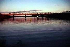
The Murray Rail Bridge crosses the Murray River between Murray Bridge and the nearest settlement of Perponda, South Australia.
Sister cities
Murray Bridge has two sister cities, according to the Australian Sister Cities Association.
Gallery
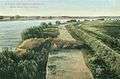 Murray Bridge in 1912.
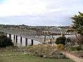 The Murray Bridge road (left, 1879) and rail (right, 1924) bridges over the River Murray.
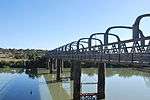 The 1879 road bridge.
 Grandstand at the Murray Bridge Racetrack.
Notable residents
- Ben Wilden
- James Smith
- Ben Dougall
- Danielle Catanzariti
- Bryn Coudraye
- Simon Overland
- Stephen Edward Foster
- Jo Hill
- Chad Wingard
- Donald Dunstan (governor)
- James McRae
See also
- List of cities and towns in South Australia
- Long Island Recreation Park
- List of crossings of the Murray River
- List of islands within the Murray River in South Australia
- St John the Baptist Cathedral, Murray Bridge
- Lavender Federation Trail
References
- 1 2 3 "3218.0 – Regional Population Growth, Australia, 2014-15: Population Estimates by Significant Urban Area, 2005 to 2015". Australian Bureau of Statistics. Australian Bureau of Statistics. 30 March 2016. Retrieved 12 September 2016. Estimated resident population, 30 June 2015.
- ↑ Murray Bridge Postcode. Australia Post. Retrieved on 2008-05-29
- ↑ "2011 Census Community Profiles: Murray Bridge". ABS Census. Australian Bureau of Statistics. Retrieved 15 September 2016.
- ↑ "Rural City of Murray Bridge". About Murray Bridge. Rural City of Murray Bridge. Retrieved 9 July 2012.
- ↑ "NEW TOWN NAMES APPROVED". The Advertiser (Adelaide). South Australia. 26 July 1940. p. 10. Retrieved 5 September 2016 – via National Library of Australia.
- ↑ The Road Bridge over the River Murray at Murray Bridge Thompson, M.H. Australian Railway Historical Society Bulletin, September, 1976 pp189-196
- ↑ 05 Feb 1919 - RAILWAY AFFAIRS. MURRAY LANDS. Trove.nla.gov.au (1919-02-05). Retrieved on 2014-04-12.
- ↑ "Summary of State Heritage Place" (PDF). South Australian Heritage Register. South Australian Heritage Council. Archived from the original on 9 April 2016.
- ↑ Australian Bureau of Statistics (31 October 2012). "Murray Bridge (SUA)". 2011 Census QuickStats. Retrieved 15 October 2013.
- 1 2 Australian Bureau of Statistics (25 October 2007). "Murray Bridge (Urban Centre/Locality)". 2006 Census QuickStats. Retrieved 15 March 2010.
- ↑ "History of Murray Bridge Rowing Club—The Murray Cods". Andrew Guerin. Retrieved 25 August 2015.
- ↑ http://www.murraybridge.sa.gov.au/site/page.cfm?u=417&c=12322 Archived 24 May 2011 at the Wayback Machine.
- ↑ "Climate statistics for Murray Bridge". Bureau of Meteorology. Retrieved 17 August 2011.
- ↑ Electoral Commission of South Australia (4 April 2006). "District of Hammond - Polling Booth Results". Retrieved 15 March 2010.
- ↑ Australian Electoral Commission (13 December 2007). "SA Division - Barker". Retrieved 15 March 2010. Data from the four Murray Bridge polling booths.
- ↑ Retrieved on 2013-07-17.
- ↑ The Overland Timetables Great Southern Rail
- ↑ Sister Cities International. Retrieved on 2008-05-29
External links
| Wikimedia Commons has media related to Murray Bridge, South Australia. |
- Rural City of Murray Bridge
- Australian Bureau of Statistics - Murray Bridge
- Big Stories, Small Towns Online documentary featuring video, digital stories and photo essays about Murray Bridge
- The Murray Valley Standard - local news
| Topics | ||
|---|---|---|
| Regions | ||
| Cities and towns | ||
South Australia portal | ||