Naco, Arizona
| Naco, Arizona | |
|---|---|
| CDP | |
|
US Customhouse at Naco, Arizona | |
 Location of Naco, Arizona | |
 Naco, Arizona Location in the United States | |
| Coordinates: 31°20′14″N 109°56′40″W / 31.33722°N 109.94444°WCoordinates: 31°20′14″N 109°56′40″W / 31.33722°N 109.94444°W | |
| Country | United States |
| State | Arizona |
| County | Cochise |
| Area | |
| • Total | 3.4 sq mi (8.7 km2) |
| • Land | 3.4 sq mi (8.7 km2) |
| • Water | 0.0 sq mi (0.0 km2) |
| Elevation | 4,610 ft (1,405 m) |
| Population (2010) | |
| • Total | 1,046 |
| • Density | 307.6/sq mi (120.2/km2) |
| Time zone | Mountain (MST) (UTC-7) |
| ZIP code | 85620 |
| Area code | 520 |
| FIPS code | 04-48310 |
| GNIS feature ID | 0008475 |
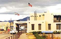
Naco, a Census-Designated Place (CDP) located in Cochise County, Arizona, United States had a recorded population of 1,046 during the 2010 census. It's located directly across the United States–Mexico border from its sister city Naco, Sonora. The Naco port of entry is open 24 hours per day.
The present-day unincorporated town of Naco, Arizona, was established in the early 20th century. The area was originally settled by the Nahua and Opata Indians. Naco means "nopal cactus" in the Opata language. The U.S. Congress officially established Naco as a Port of Entry on June 28, 1902.[1]
Geography
Naco is located at 31°20′14″N 109°56′40″W / 31.33722°N 109.94444°W (31.337287, −109.944461).[2] According to the United States Census Bureau, the CDP has a total area of 3.4 square miles (8.8 km2), all of it land.
Attractions
Naco is home to Turquoise Valley, the oldest continuously operated golf course in Arizona—the first to reach 100 continuous years of age.[3]
Demographics
As of the U.S. 2010 census,[4] there were 1046 people, 334 households, and 284 families residing in the CDP. The population density was 307.6 people per square mile (120.2/km²). The racial makeup of the CDP was 62.8% White, 0.67% Native American, 33.7% from other races, and 2.88% from two or more races. 83.9% of the population were Hispanic or Latino of any race.
There were 334 households out of which 146 had children under the age of 18 living with them.
In the CDP the age distribution of the population shows 40.5% under the age of 18, 5.9% from 18 to 24, 11% from 25 to 34, 15.8% from 35 to 49, 15% from 50-64, and 11.7% who were 65 years of age or older. The population of Naco, by 2010 census estimates, is 48.7% male, 51.3% female.
According to the 2000 census, the median income for a household in the CDP was $22,045, and the median income for a family was $25,227. Males had a median income of $21,923 versus $15,882 for females. The per capita income for the CDP was $9,169. About 33.0% of families and 34.2% of the population were below the poverty line, including 46.1% of those under age 18 and 25.4% of those age 65 or over.
Prehistoric Naco
The Naco-Mammoth Kill Site is located near Naco. Excavations from this archeological site in the 1950s revealed mammoth bones with embedded Clovis points, providing evidence of the hunting activities of Paleo-Indians some 13,000 years ago.[5]
Fort Naco
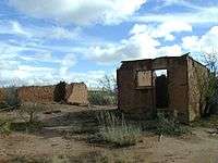
Fort Naco is a former military post on the outskirts of Naco. Subsequent to Pancho Villa's raid on Columbus, New Mexico, in 1916, Fort Naco was a staging area for American troops protecting the border. It was the headquarters of the 1st Infantry Regiment of the Arizona National Guard.[6]
See also
- Bombing of Naco – the first ever aerial bombardment of the continental United States by a foreign power
References
- ↑ "The Naco, Arizona Port of Entry: Archaeology on the Border". U.S. National Park Service. Retrieved 4 November 2012.
- ↑ "US Gazetteer files: 2010, 2000, and 1990". United States Census Bureau. 2011-02-12. Retrieved 2011-04-23.
- ↑
- ↑ "American FactFinder". United States Census Bureau. Archived from the original on 2013-09-11. Retrieved 2008-01-31.
- ↑ Barbara Grijalva. Arizona ice age: Man vs. mammoth. KOLD News. Posted: Apr 19, 2010. Kold.com. Retrieved on 2011-05-27.
- ↑ Camp Naco preservation
External links
- Naco history and prehistory, by National Park Service (English & Spanish)
Municipalities and communities of Cochise County, Arizona, United States | ||
|---|---|---|
| Cities |  | |
| Towns | ||
| CDPs | ||
| Unincorporated communities |
| |
| Ghost towns |
| |