Naldurg
| Naldurg नळदुर्ग | |
|---|---|
| city | |
|
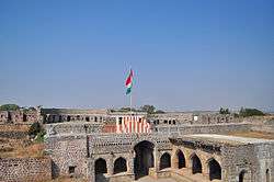
Hulmukh Darwaza, Naldurg fort | |
 Naldurg Location in Maharashtra, India | |
| Coordinates: 17°49′N 76°18′E / 17.82°N 76.3°ECoordinates: 17°49′N 76°18′E / 17.82°N 76.3°E | |
| Country |
|
| State | Maharashtra |
| District | Osmanabad |
| Area | |
| • Total | 7,550 km2 (2,920 sq mi) |
| Elevation | 566 m (1,857 ft) |
| Population (2011) | |
| • Total | 18,341[1] |
| Languages | |
| • Official | Marathi |
| Time zone | IST (UTC+5:30) |
| Sex ratio | 52%/48% ♂/♀ |
Naldurg is a city and a municipal council in Osmanabad district in the Indian state of Maharashtra.
Geography
Naldurg is located at 17°49′N 76°18′E / 17.82°N 76.3°E, 438 km from Mumbai.[2] It has an area of 7550 km² and average elevation of 566 metres (1856 feet). The temperature ranges from 10.1°C to 43.1°C, and the average yearly rainfall is 760mm.
Naldurg has two sub-divisions (Osmanabad and Bhum), and eight talukas (Osmanabad, Tuljapur, Lohara, Umarga, Kalamb, Bhum, Paranda, Vashi).
Population
As of 2011 India census,[3] Naldurg had a population of 18,341. Males constitute 52% of the population and females 48%. Naldurg has an average literacy rate of 84.10%, higher than the state average of 82.34%. Male literacy is 90%, and female literacy is 78%. In Naldurg, 15% of the population is under 6 years of age.[1] Schedule Caste (SC) constitutes 11.61 % while Schedule Tribe (ST) were 0.95 % of total population in Naldurg.[1] Languages spoken include Marathi and Kannada[4][5]
History
The Naldurg fort is one of the important ground forts in the Marathawada region. It represents a fine example of the medieval architectural style.
Naldurg was formerly a district headquarters is situated about 50 kilometres (31 mi) south-east of Osmanabad. The fort is an interesting place which encloses a knoll of basalt rock which juts out into the valley of the small Bori River. Along the rest of the cliff on three sides ran fortifications. A bastion is firmly built out of basalt and is large enough to carry heavy guns. The entire circumference is about a mile and a half.
The interior portion is covered with ruined walls and a wide road running up to the centre. The fort has many bastions amongst which are upli Buruj, which is the height point in the Fort Paranda Buruj, nagar Buruj, Sangam Burug, Sangram Buruj, Bands Buruj, poone Buruj, etc. Inside the fort there are remains of the walls and some of the building such as Barood kotha, Baradari, Ambarkhana, and Rangaan mahal, Jali. Though the buildings are in ruins the remains give the impression that there might have been at one time other buildings. There are two tanks in the fort known as machali guns amongst which the most important are the “hathi toph” and magar Toph”, The hathi Darwaza. The hurmukh and the hurmukh darwaza are the main gates of the fort. An interesting building which connects the fort and the Ranmandala is the dam constructed across the Bori River. The dam and the ”pani mahal" built underneath and in the middle of the dam were built during the reign of Ibrahim Adil shah II In 1613.
It is believed that the fort was built by Nalaraja (The King Nala). The fort and the city is named after him. The fort was built in the period of the Chalukya kings of Kalyani. Later, from 1351 to 1480, in the period of the [Bahamani] kings. In 1558, the Adil Shahi rulers, after the downfall of Adil Shahi Kingdom, Naldurg passed into the hands of Moghalain the year 1686. A.D. Nizamul Mulk Asif Jah was appointed as Governor of the entire Deccan from Central India and Gujrat up to Kanya Kumari. After the death of Aurangzeb Nawab Nizamul Mulk Asif Jah Bahadur founded the Nizam Domanion. During the time of II Nizam The Governor (Subedar) became a rebel and Causing Havoc to the Subject Then the Asif Jah II, Nawab Nizam Ali khan send his Afghan General Mohammed Dulah Khan. General Mohammed Dulah Khan conquered the province crushed the mutiny and took the traitor into his custody. Nizam the II Appointed Nawab Mohammed Dulah khan Bahabdur as a Governor (Subedar) with the title of Nawab Karar Nawaz Jung Bahadur. Then his son Nawab Amir Nawazul Mulk Bahabdur became the Governor of Naladrug. He ruled very successfully. He was not only kindhearted but generous when there was a theft of 1 1/2 Quintal gold from the Tulja Bhawani Temple. He donated the gold from his personal treasure to compensate. The most important historical marriage which took place at Naldrug Fort at Rang Mahal was the marriage of Chand Bibi Sultana. This wedding took place between the two kingdoms: Adil Shahi and Nizam Shahi
The Makhbara (Shrines) of Nawab Amir Nawazul Mulk Bahadur and beside him Princess Fakharunnisa Begam, daughter of Nizam ul Mulk II Mazars are at Naldrug. Not only the people of Naldrug but the entire Marathawada people visit the shrine to pay respect to their late ruler. After the death of Nawab Sahab his successors became the Governors until 1948. The present successor, seventh in line, is Nawab Mohammed Iqbal Ali Khan Bahadur (Nawab of Balaghat, Asaf Jahi). Still the property of Nawab Sahab is there, and he and his sons frequently make the tour to Naldurg as they have sentimental affection for the soil and people.
The Naldurg fort is one of the important ground forts in the Marathawada region. It represents a fine example of the medieval architectural style.

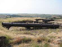

These cannons have figures of elephants and crocodiles and are therefore called Hathi Toph (मराठी: हत्ती तोफ) and Magar Toph (मराठी: मगर तोफ). There are some old buildings still standing in good condition.
Agriculture
It has an area under irrigation of 1186.76 km² and an area under horticulture: 14.6 km². The main crops are jowar, bajra, and tur.
The Osmanabad goat is a tough breed, always in demand by farmers across the country.
Infrastructure
Situated in the region are 12 rural hospitals, 42 district hospitals, and one PHC. In terms of education infrastructure, there are eight primary schools, four secondary schools and one college. The town has one state Bus Transport Station.
Culture
Tulja Bhavani, revered deity of Maharashtra, at whose feet Chhatrapati Shivaji Maharaj received inspiration to establish Hindvi Swaraj, is at Tuljapur and is in this district in which Shree Sant Goroba was born. Naldurg fort is an architectural marvel and its palace below the water attracts tourists and researchers alike, even after five centuries. Umarga and Sastoor were uprooted in the massive earthquake of 1993.
Folk arts
Bhajan, Kirtan, Jogwa, Gondhal
Temples
- Khandoba Mandir
- Shree 1008 Bhagwan Adhinath Mandir
- Gautam Buddha Vihar
- Ambabai Mandir
- Rokdya Maruti Mandir (NH-9)
- Ganesh Mandir
- Vithal Rukumini Mandir (Vyas Nagar)
- Mahadev Mandir
- Ichyapurti Hanuman Mandir (Vyankatesh Nagar)
- Dargah Hajrat Sayyed Sadik Shah Wali
- Dargah Hajrat Sayyeda Nanima sarkar
- Dargah Hajrat Sayyed Burhan Shah Wali
- Shri Ram Mandir
- Mallikarjun Mandir
- EKNATHIDEVI MANDIR (Hangarga nal)
- Hanuman Mandir( Bhavani Chowk)
Masjid
- Jama Masjid
- Shahi Jama Masjid(inside Fort)
- Hamid kha Masjid
- Bajar Line Masjid
- Multan Mohalla Masjid
- Aasar Masjid
- Qureshi Masjid
- Bagwan Masjid
- Sohel kha Masjid
- Nanima Masjid
- Indira Nagar Masjid
- Noorani Masjid, Rahim nagar
- Rahim Nagar Markas Masjid
- Aaliyabad Masjid
- Ramtirh Masjid
Tourist places

- Tuljapur tuljabhavani mandir
- Naldurg fort
- Akkalkot
- Shree Ram Mandir at Ramtirth
- Ranilakshami park
See also
References
- 1 2 3 "Naldurg City Population". census 2011. Retrieved 19 July 2015.
- ↑ Falling Rain Genomics, Inc - Naldurg
- ↑ "Census of India 2001: Data from the 2001 Census, including cities, villages and towns (Provisional)". Census Commission of India. Archived from the original on 2004-06-16. Retrieved 2008-11-01.
- ↑ The Dynasties of the Kanarese Districts of the Bombay Presidency"(1894) J.F.Fleet, Gazetteer of the Bombay Presidency (Vol-1, Part-II, Book-III) ISBN 81-206-0277-3.
- ↑ Barnett, L. D. (1910). "A catalogue of Kannada, Badaga and Coorg books" (PDF). Retrieved 5 March 2016.