Narin, County Donegal
| Narin an Fhearthainn | |
|---|---|
| village | |
 Narin Location in Ireland | |
| Coordinates: 54°50′19″N 8°26′47″W / 54.838748°N 8.446482°WCoordinates: 54°50′19″N 8°26′47″W / 54.838748°N 8.446482°W | |
| Country | Ireland |
| Province | Ulster |
| County | County Donegal |
| Time zone | WET (UTC+0) |
| • Summer (DST) | IST (WEST) (UTC-1) |
| Irish Grid Reference | G818944 |
| Narin is the official spelling. | |
Narin (Irish: An Fhearthainn) is a small seaside village in the parish of Ardara on the southwest coast of County Donegal, Ireland. The topography is rough rolling bogland and craggy low hills. Narin Strand is a sand beach approximately two kilometres long. Inishkeel island is located approximately 250 metres from the mainland in Gweebarra Bay and can be reached on foot at low tide by crossing a tidal sand bank. The population of Narin is spread sparsely around the countryside in mostly modern housing. There is a large tourist trade served by several B&Bs and caravan parks. The local amenities consist of two pubs, The Cope convenience store and beach front and caravan park shops. There is also an 18 hole golf course with club house. Narin lies at an altitude of 12 metres (42 feet) and lies 8 km north of Ardara, 11 km northwest of Glenties and 13 km south of Dungloe.[1]
Gallery
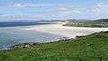 Narin Strand
 Sunset over Portnoo from Narin Strand
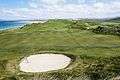 Narin & Portnoo Golf Club
References
- ↑ "Naran, Ireland Page". www.fallingrain.com. 27 August 2016. Retrieved 21 September 2016.
See also
Places in County Donegal | ||
|---|---|---|
| Towns |  | |
| Villages |
| |
| Townlands | ||
| Islands | ||
| Other regions | ||
| ||